YARMOUTH, ME — February 05, 2007 — DeLorme, the innovation leader in mapping and GPS technology, today introduced the Earthmate GPS PN-20, the only handheld GPS that can display DeLorme maps and aerial imagery.
The Earthmate GPS PN-20 is a unique all-in-one GPS and mapping solution. Unlike other handheld GPS manufacturer's devices, no additional mapping software purchase or subscription is required. DeLorme Topo USA 6.0 DVD software is included with the device, with beautifully detailed topographic and road maps of the entire U.S., available aerial imagery, and a broad range of GPS capabilities.
"The quality and detail of our Topo USA software is one thing that truly distinguishes the Earthmate GPS PN-20 from its competition," said DeLorme Director of Marketing Caleb Mason. "Another is the fact that it's included with the receiver. That's an enormous added value."
Topo USA 6.0 works with Microsoft Windows Vista as well as Windows 2000 and XP.
Unique Position in the Handheld GPS Market
DeLorme is the only company in the handheld GPS market with a long-standing reputation for excellence in cartography, software development, and GPS.
"We've been making maps for over 30 years," continued Mason. "But what's truly innovative about the PN-20 is the inclusion of six map types on one color-screen GPS. You get a world base map, U.S. streets and topographic maps from Topo USA, regional routable maps, free downloads of scanned USGS quad maps, black-and-white aerial imagery, and colorized satellite imagery – all included in the base price, no extra map sources required."
High-End Capabilities
Based on features, capabilities, and "under the hood" power, the Earthmate GPS PN-20 is fully-positioned to compete at the high end of the handheld GPS market.
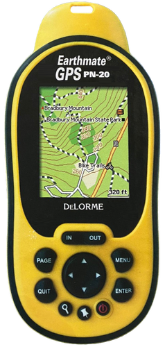
Its high resolution (220 x 176 pixel) transflective color screen delivers exceptional visibility under a wide variety of conditions, including direct glaring sunlight.
The 12-channel, NMEA-compliant receiver includes STMicroelectronics chip technology with SiGE front-end noise reduction, plus DeLorme firmware for fast acquisition times and outstanding signal retention.
The device is WAAS-enabled for accuracy within meters. With its proprietary Kalman filter, the Earthmate GPS PN-20 also addresses the complex problem of reflected GPS signals, which could otherwise greatly decrease positional accuracy.
Included Topo USA 6.0 Software Adds Exceptional Value
The included Topo USA 6.0 DVD software is a powerful pre-trip travel planning and post-trip data management tool. Users can automatically create road and trail routes, with GPS waypoints embedded.
The program's draw tools allow users to create tracks and insert waypoints as well.
Maps can be cut specifically for the area needed and symbols and annotations added. Aerial imagery can also be uploaded for GPS tracking and indispensable birds-eye visual reference. Up-close views reveal hiking and jeep trails, as well as structures, waterways, and other landmarks.
Map files, aerial imagery, routes, waypoints, and tracks can be uploaded to the Earthmate GPS PN-20. The device has exceptional data capacity, holding up to 10 tracks (10,000 points per track), as well as 1,000 user-defined waypoints, and up to 50 routes. A full 75 MB of internal flash memory is available for maps, as well as an SD Card slot within the battery compartment, capable of working with 2 GB or less cards (ideal for large-volume aerial imagery files).
Exclusive DeLorme Features
The software's automatic trail routing is an exclusive DeLorme feature, as is the ability to download and save collected tracks as routable roads and trails within the software for future use. Any collected waypoints, tracks, symbols, comments, and other data can be easily downloaded and managed within the Topo USA software.
In addition to the Topo USA nationwide map coverage, the receiver comes pre-loaded with a worldwide highway/major thoroughfare reference base map. The Earthmate GPS PN-20's intelligent data layering feature allows users to easily toggle between maps and aerial imagery of the same location, ideal for hikers, campers, bikers, and others looking for multiple views of outdoor locations.
When GPS tracking on an uploaded road or trail route, an audible signal warns of upcoming turns, and there is a back-on-track feature should users go off course while driving or hiking along a route. On-device road routing is also available, with back-on-track and turn alerts, so the Earthmate GPS PN-20 is also a reliable in-vehicle navigation device.
With its waterproof rubberized housing, the Earthmate GPS PN-20 is designed for rugged outdoor use. It measures just 2.43" W x 5.25" H x 1.5" D and weighs only 5.12 oz., with an ergonomic design and large, easily accessible function keys.
Look for the Earthmate GPS PN-20 at retail stores and online sites where outdoor, electronics, or GPS products are sold. It is competitively priced at $419.95, with Topo USA software, a 1 gigabyte SD card, and SD card reader included. Other options are available direct from DeLorme, beginning at $369.95.
About DeLorme
DeLorme is the longtime leader in innovative mapping and GPS solutions for both consumer and professional markets. The company's trailblazing Street Atlas USA and Topo USA consumer software have set the standards for GPS, routing, and travel planning capabilities. DeLorme XMap software is expanding the GIS market through its advanced capabilities, affordable pricing, and ease of use. The company's Earthmate receivers pioneered the concept of GPS for laptop PCs and PDAs. Today, the innovation continues with the Earthmate GPS PN-20 handheld receiver, the Earthmate GPS BT-20 with dual Bluetooth and USB connectivity, and the DeLorme GPS2056 Receiver Module for OEM electronic systems. Located in Yarmouth, Maine, DeLorme is home to Eartha, the world's largest rotating globe.