SALT LAKE CITY, UT — August 06, 2008 — DeLorme, the leader in mapping and GPS technology for serious outdoor adventures, today announced the Fall 2008 release for its next generation handheld GPS, the Earthmate PN-40. The new device’s rugged design, tested in both Arctic and Antarctic conditions, makes it the ideal choice for serious outdoor adventures.
The announcement came during the Open Air Demo event at Pineview Reservoice, a prelude to the Outdoor Retailer Summer Market 2008 show, scheduled for August. 8-11 in Salt Lake City. DeLorme is exhibiting at Booth 19010.
The PN-40 will be powered by the 32-channel STMicroelectronics Cartesio chipset for near-instantaneous signal acquisition. DeLorme ConstantLock enables sure-fire satellite retention in challenging GPS environments such as forest canopies.
Lightning-Quick Performance, New 3-Axis Compass
A new dual-core processor delivers immediate screen renderings, even with large color aerial imagery files.
With 500 MB of onboard flash memory, the PN-40 can easily handle a vast amount of map and imagery data. In addition, its SD card slot supports high-capacity SDHC cards currently available at up to 32 GB. SD card data exchanges can be sent directly to the card while in the PN-40 via USB 2.0.
The PN-40’s new 3-axis electronic compass can be used while held in any position (many other electronic compasses require being held in a horizontal aspect). Also new is a sensitive barometric altimeter for reliably accurate altitude readings (with user calibrations possible).
Exclusive High-End Capabilities Via Topo USA
One thing that sets the PN-40 apart from other handheld GPS receivers is its powerful partnership with the accompanying DeLorme Topo USA 7.0 mapping software.
Topo USA 7.0, enables the to import supplemental data including four types of aerial imagery, USGS 1:24,000 quads, and NOAA nautical charts for use with Topo USA on the PC, or displayed on the PN-40. No other receiver can display such a wide variety of map and imagery options.
With the new DeLorme Map Library Annual Subscription plan, users can purchase an unlimited amount of supplemental data for only $29.95 via the Topo USA 7.0 NetLink tab (Internet connection required).
Topo USA 7.0 delivers countless high-end mapping and GPS capabilities. One exclusive feature is the ability to automatically create trail routes, which enables users to easily send their hiking routes to the PN-40 or other popular model GPS receiver, rather than laboriously loading trail points.
Topo USA also uniquely enables users to import collected GPS tracks into Topo USA and convert them to routable roads or trails, viewing and editing as desired and saving for future usage. Indispensable desktop features include realistic 3-D views with flyovers and 360-degree rotation, detailed elevation profiles, public lands for recreation, over 4 million places of interest, and the most up-to-date road detail available on any topographic maps.
Rock-Solid Reliability in Even the Most Challenging Conditions
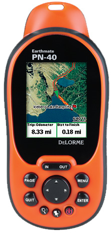
The PN-40 has a 65K-color daylight-readable TFT screen for clarity in any light conditions, and is WAAS-enabled for the best possible positional accuracy. It has an impact-resistant and waterproof (IPX7) rubberized housing, and uses the same rock-solid push-button interface as the still-available Earthmate PN-20, which has performed successfully in the world’s most challenging environments.
DeLorme was the GPS provider for a pair of recent Baffin Island, Canada expeditions. The PN-20 was used on both Will Steger’s Global Warming 101 trip in 2007, and Ed Viesturs’ 2008 Canadian Arctic Trek for Earth Health.
Viesturs, who had accompanied Steger on the Global Warming 101 trek, said he was impressed with the PN-20’s performance and simplicity of use, and was happy to be similarly outfitted for this year’s expedition.
John Huston, who was base camp manager for Steger, also relied on a PN-20 during a 720-mile trip he led to the South Pole from November 2007 to January 2008.
In March of 2009, Huston and Tyler Fish will embark on North Pole ’09, equipped with an Earthmate PN-40 (DeLorme is also helping to underwrite the expedition). Following his South Pole trip, and a training expedition this year on Baffin Island, Huston had this to say:
“The Delorme Earthmate makes it easy to navigate. The customization options make the displayed pages and information easy to access, which simplifies navigation a great deal. When traveling in the world's polar regions we need a GPS that is reliable and easy to use. The Earthmate is our choice, we see it as an honest friend on the ice. it never lies to us and records our progress faithfully.”
When the PN-40 hits store shelves this Fall, it will be available at major outdoor retailers as well as online GPS resellers.
About DeLorme
DeLorme is the longtime leader in innovative mapping and GPS solutions for both consumer and professional markets. Based in Yarmouth, ME, DeLorme offers a unique set of core competencies across the complex areas of map data creation and management, software development, and integration with GPS. The ability to develop all the critical components necessary to compete in the fast-changing navigation world provides a distinct competitive advantage. DeLorme is one of a handful of mapmakers that still own and produce their own content, and its Street Atlas USA, Topo USA, and Earthmate GPS products have introduced countless first-to-market innovations.