YARMOUTH, ME — January 07, 2009 — DeLorme, the leader in mapping and GPS technology for serious outdoor adventures, is enjoying a strong launch of its new Earthmate PN-40 handheld GPS. The new device’s exceptional performance and DeLorme’s unique map and imagery options make it a superior choice for serious outdoors enthusiasts, geocachers, and active families.
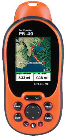
The PN-40 is powered by the high-sensitivity 32-channel Cartesio chipset, by STMicroelectronics, for no-wait satellite acquisition. DeLorme ConstantLock provides sure-fire signal retention, even under forest cover and in other challenging GPS environments.
A powerful dual-core processor delivers lightning-quick performance. Features include a 3-axis electronic compass, usable while held in any position; and a sensitive barometric altimeter for reliable altitude readings.
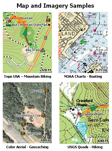
Detailed Maps, Aerial Imagery, NOAA Nautical Charts
The PN-40 comes with Topo USA 8.0 software included (no extra purchase required). Topo USA puts the most up-to-date topographic maps available in the user’s hand. Built on 1:100,000 U.S. Geological Survey (USGS) data, Topo USA displays current terrain and land cover detail plus updated DeLorme street and road data—everything from interstate highways to remote back roads.
In addition, Topo USA links users to a unique menu of supplemental data, including high-resolution aerial imagery, NOAA nautical charts, and USGS 7.5-min. quad maps.
No other handheld GPS provider can match DeLorme’s map and supplemental data offerings. With the new DeLorme Map Library Annual Subscription plan, users can purchase an unlimited amount of supplemental data for only $29.95.
GPS for Serious Outdoor Adventures
With its blazing-fast performance, high-end features and unrivaled map and data options, the PN-40 is staking out a leadership position as a GPS for serious outdoor activities, including hiking, backpacking, geocaching, hunting, fishing, kayaking, boating, snowmobiling, and many more.
“We developed the PN-40 as a serious, practical tool for reliable performance in any navigational situation or condition,” said Caleb Mason, Director of Marketing at DeLorme. “At the same time, the PN-40 reflects DeLorme’s well-established reputation for forward-thinking innovation.”
Many of the PN-40’s distinctive capabilities are tied to its performance partnership with Topo USA. The software enables users to view the supplemental aerial imagery, NOAA charts and USGS quads on the PC as well as on the PN-40. That, along with Topo USA’s superior road and trail data, its realistic 3-D terrain views, and 4 million places of interest, enables a level of scouting, trip planning, and routing that no other GPS provider can offer.
Unique Capabilities
One exclusive Topo USA feature is the ability to automatically create trail routes rather than laboriously loading trail points. Both road and trail routes can easily be sent to the PN-40.
Topo USA also uniquely enables users to import collected GPS tracks and quickly convert them to routable roads or trails.
For geocachers, the PN-40 and Topo USA allow a generous 800 characters for cache descriptions. It supports both .gpx and .loc files.
Easy Photo Geo-Tagging
The PN-40 and Topo USA offer a simple way to locate the exact position where any digital photos were taken during a hike, kayaking trip, geocaching, or other outdoor adventure.
Rock-Solid Reliability
The PN-40 has a 65K-color daylight-readable TFT screen for clarity in any light conditions, and is WAAS-enabled for the best possible positional accuracy.
It has an impact-resistant and waterproof (IPX7) rubberized housing, and offers the same rock-solid reliability as the still-available Earthmate PN-20, which has performed successfully in the world’s most challenging environments.
DeLorme was the GPS provider for a pair of recent Arctic expeditions—Will Steger’s Global Warming 101 trip in 2007, and Ed Viesturs’ 2008 Canadian Arctic Trek for Earth Health. John Huston, who was base camp manager for Steger, also relied on a PN-20 during a 720-mile trip he led to the South Pole culminating in January 2008. In March of 2009, Huston and Tyler Fish will embark on North Pole ’09, equipped with an Earthmate PN-40 (DeLorme is helping to underwrite the expedition).
“When traveling in the world's polar regions, we need a GPS that is reliable and easy to use,” said Huston. “The Earthmate is our choice; we see it as an honest friend on the ice.”
Availability
The PN-40 will be available Thanksgiving week at retail stores and online sites specializing in GPS, outdoor recreation, and electronics products. Major outlets include REI (retail and online), Amazon.com, Walmart.com, TigerGPS.com, Cabela’s, and Bass Pro Shops.
About DeLorme
DeLorme is the longtime leader in innovative mapping and GPS solutions for both consumer and professional markets. Based in Yarmouth, ME, DeLorme offers a unique set of core competencies across the complex areas of map data creation and management, software development, and integration with GPS. The ability to develop all the critical components necessary to compete in the fast-changing navigation world provides a distinct competitive advantage. DeLorme is one of a handful of mapmakers that still own and produce their own content, and its Street Atlas USA, Topo USA, and Earthmate GPS products have introduced countless first-to-market innovations.