YARMOUTH, ME — June 24, 2009 — DeLorme, the innovation leader in mapping and GPS technology for outdoor adventures, today announced its upcoming release of the Earthmate PN-30 handheld GPS receiver. It offers top-end GPS capabilities, plus the PN-Series’ exclusive aerial imagery display features, but it’s also affordably priced and easy to use.
DeLorme PN-Series topographic map DVDS are included for effortless transfers to the device; users can load the maps they need and be ready to go within minutes of opening the package.
In the field, users will discover lightning-quick satellite acquisition, thanks to the high-sensitivity 32-channel Cartesio chipset. Signal retention is ultra-reliable even in dense forests. A powerful dual-core processor renders map and imagery screen views with instantaneous speed.
The PN-30 is waterproof and WAAS-enabled for superior accuracy, and has a bright-color TFT screen for readability in any light conditions. With all those features, the PN-30 carries a remarkably affordable $299.95 suggested retail price.
Detailed Maps, Aerial Imagery, NOAA Nautical Charts
The included PN-Series Map DVDs will transfer maps to the PN-30 or an SD card, from either PCs or Macs. The up-to-date detail includes U.S. topography, U.S. and Canada streets, roads, and places of interest, and Mexico main roads.
Also included is a sample certificate for the online DeLorme Map Library, where users can go to download aerial imagery, USGS 1:24,000 topographic quads, and NOAA nautical charts. All Map Library downloads can be sent directly to, and displayed on the PN-30. For a low-cost $29.95 annual subscription, users can download and keep all the Map Library maps and imagery they want (PC and Mac accessible).
With all these map and imagery options, the PN-30 offers exceptional versatility for a wide range of activities, including hiking, mountain biking, fishing, boating, kayaking, geocaching, and more. No other handheld GPS provider can match DeLorme’s map and supplemental data offerings.
Support for Navionics Charts
The PN-30 also displays Navionics HotMaps (lake) and Gold (marine) charts, which are sold separately by major boating and sporting goods suppliers. Widely recognized as the leader in charts by boaters and anglers, Navionics charts come on SD cards that are instantly recognized by the PN-30; no setup is required.
Unique Topo USA Mapping Software Included
For desktop mapping on the PC, the PN-30 comes with newly-released DeLorme Topo USA 8.0 DVD software. Users can scout their trips in advance, create road and trail routes automatically, print maps, geo-tag photos with their exact GPS location and much more.
Topo USA also uniquely enables users to import collected GPS tracks and quickly convert them to routable roads or trails.
Topo USA generates realistic 3-D views of any U.S. location, with flyovers, and displays aerial imagery, USGS quad, and NOAA nautical chart downloads from the DeLorme Map Library. The up-to-date detail includes 4 million places of interest, plus campgrounds, boat ramps, BLM lands, and national parks and forests. Full print capabilities are available.
Paperless Geocaching
The PN-30 and Topo USA provide a wide range of paperless geocaching capabilities. There is a virtually unlimited character count for cache descriptions, and the new Cache Register widget (available only online from DeLorme) enables fast and easy synchronization of Pocket Query search results from Geocaching.com.
Rock-Solid Reliability
The PN-30 has an impact-resistant and waterproof (IPX7) rubberized housing. PN-Series receivers have performed successfully in some of the world’s most extreme conditions - most recently during this year’s Victorinox North Pole 09 expedition, and famed climber Ed Viesturs’ May ascent of Mt. Everest.
Availability
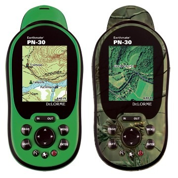
The PN-30 will be available beginning in July 2009 at retail stores and online sites specializing in GPS, outdoor recreation, and electronics products. Customers can choose the PN-30 in either Safety Green or genuine Realtree AP camouflage.
About DeLorme
DeLorme is the longtime leader in innovative mapping and GPS solutions for both consumer and professional markets. Based in Yarmouth, ME, DeLorme offers a unique set of core competencies across the complex areas of map data creation and management, software development, and integration with GPS. The ability to develop all the critical components necessary to compete in the fast-changing navigation world provides a distinct competitive advantage. DeLorme is one of a handful of mapmakers that still own and produce their own content, and its Street Atlas USA, Topo USA, and Earthmate GPS products have introduced countless first-to-market innovations.