Managing Location Data with BaseCamp
23 July 2009 @ 5:00 AM /
Trail Tech /
|
After using a Garmin handheld for a period time, users realize value in the
data collected by their devices. Stored waypoints to mark important
locations; collected track logs record hikes along scenic trails or perhaps
property boundaries for surveyed land. Still other users plan hikes and
trips at their computer and send the location-related data to their handheld
GPS for use during their excursion. |
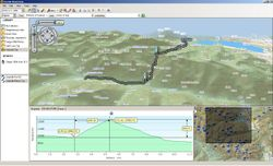 |
Garmin's
BaseCamp application is designed specifically for handheld GPS
enthusiasts. Along with supporting our topographic content, BaseCamp
interfaces with handheld Garmin GPS devices and manages location-based
content to get the most from each device. This free desktop application for PC
and
Mac is available for download and easily extracts waypoints, tracks, and
routes from a GPS and organizes the data on the computer; BaseCamp even
enables transferring data back to your GPS - simply select the information
to send to the device and BaseCamp handles the transfer. |
|
BaseCamp works with every Garmin handheld, but newer devices such as the
Dakota series and
Oregon 550 devices do even more with BaseCamp than previous products.
Earlier mass storage devices imported and exported routes, waypoints,
tracks, and geocaches using a GPX file
format. However, these newer products share the GPX files with programs like
BaseCamp, allowing BaseCamp to edit or remove location data from Garmin GPS
devices - two features previously difficult to achieve on desktop
applications.
This new functionality is particularly useful because it allows users to
collect data in the field, expand on the location data at a computer, and
immediately benefit by having the changes reflected on the device.
|

