OLATHE, Kan.--(BUSINESS WIRE)-- Garmin International,
Inc., a unit of Garmin Ltd. (NASDAQ:GRMN), today announced the all-new GPSMAP 86
handheld series, a feature-packed addition to its popular marine handheld
collection. Combining Garmin’s premium GPS navigation with inReach satellite
communication technology, the flagship GPSMAP 86sci is
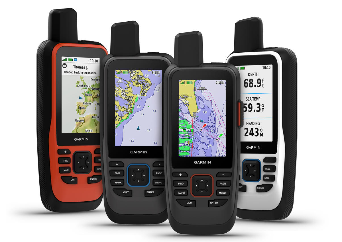
the first handheld to come preloaded with Garmin BlueChart g3 coastal
cartography with integrated Navionics data. For added awareness and convenience,
the GPSMAP 86 series can connect to onboard Garmin chartplotters and instruments
to stream real-time boat data, including depth, heading, sea temperature and
more, directly to the handheld. With a sunlight-readable 3-inch color display
and water-resistant, floating design, they even double as a remote control for
convenient operation of an onboard Garmin autopilot or select FUSION marine
stereos and speakers.
“With the addition of our industry-leading inReach satellite communication
technology and best-in-class marine mapping, no one should leave the dock
without one. Loaded with premium features in an all-new design, the GPSMAP 86
marine handhelds are fully capable of being both a primary navigation device or
as an extension and backup to your onboard system.” said Dan Bartel, Garmin vice
president of global consumer sales. “With the addition of our industry-leading
inReach satellite communication technology and best-in-class marine mapping, no
one should leave the dock without one.”
The GPSMAP 86 series offers Garmin inReach two-way messaging and location
tracking technology, so no matter how far off shore the trip may be, users can
stay in touch. Using the worldwide coverage of the Iridium satellite network,
the GPSMAP 86sci and GPSMAP 86i allow users to communicate with any cell phone
number, email address or other inReach device while using GPS to track and share
progress of the journey. If the user enables LiveTrack, friends and family on
shore wanting to follow along can view the user’s location. The GPSMAP 86sci and
86i also include a mount for hardwiring on the boat, and wireless unit-to-unit
connectivity lets users remotely connect to the GPSMAP to send and receive
messages on the chartplotter with the handheld securely mounted in a convenient
location.
Mariners can use the GPSMAP 86sci and 86i to trigger an interactive SOS for
emergency help from a 24/7 GEOS International Emergency Response Coordination
Center. The world leader in emergency response solutions and monitoring, GEOS
will alert emergency responders and provide updates to the user’s key contacts,
while also continuing to message back and forth with the user, until the
situation is resolved.
To access the Iridium network and communicate with a GPSMAP 86sci or 86i device,
an active satellite subscription is required. A variety of subscription plans
are available for both individuals and groups/fleets, and mariners will
appreciate the flexible month-to-month options that can be suspended in the
offseason if desired.
Both the GPSMAP 86sci and GPSMAP 86sc come preloaded with BlueChart g3 coastal
charts for industry-leading coverage, clarity and detail with integrated Garmin
and Navionics data. Detailed contours allow users to see 1-foot contours that
provide a more accurate depiction of bottom structure for improved fishing
charts and enhanced detail in canals and port plans. Users can also add LakeVü
g3 inland maps with coverage for more than 17,000 lakes to select models. The
international versions, the GPSMAP 86s and 86i, come preloaded with a worldwide
basemap.
It’s easier than ever to stay in touch with a GPSMAP 86 handheld onboard. Each
device offers Wi-Fi connectivity, ANT+ technology and Bluetooth wireless
technology for easy wireless updates and connections, including smart
notifications when paired with a compatible smartphone. When paired with the
free Garmin Explore app, users can upload their favorite waypoints, tracks and
routes and have access to additional tools and features for trip planning,
mapping and data sharing. Additionally, the GPSMAP 86 series features support
for the Connect IQ app, a no-cost all-in-one store where users can access free
apps, widgets and data fields to customize their handheld. Each new GPSMAP
handheld comes with an internal, rechargeable lithium battery. Get up to 40
hours of battery life in standard mode and up to 200 hours of battery life in
expedition mode with the GPSMAP 86sc and 86s. The GPSMAP 86sci and 86i provides
up to 35 hours of battery life in 10-minute tracking mode and up to 200 hours of
battery life in expedition mode.
The new GPSMAP 86 marine handheld series is available now with suggested retail
prices ranging from $399.99 to $649.99.