Find your next adventure with the rugged
Tread 2 powersports navigator from Garmin
Tuesday, 5 November 2024, 5:22 am CST
Powerful off-road device handles all terrains, boasts a
high-resolution display and advanced navigation tools to help you
explore with confidence
OLATHE, Kan./November 5, 2024/PR Newswire – Garmin (NYSE:
GRMN) today announced the rugged Tread 2 off-road navigator that guides
adventures on dirt, snow and everything in between. Purpose-built for
snowmobile, side-by-side, ATV, UTV and motorcycle enthusiasts, the next-gen
Tread 2 features an ultrabright 6-inch touchscreen display, turn-by-turn
navigation, topographic maps and more to enhance any journey. Additionally,
Garmin announced the new Handlebar Controller (sold separately) that offers
riders more convenient navigator control from their handlebars.
“We created the Tread 2 for our off-road customers who never back down from a
challenge. Built tough, the device is designed to guide you through all types of
conditions and stand up to extreme weather. It also comes packed with a wide
range of mapping options, giving adventure seekers confidence to take the path
less traveled.” – Dan Bartel, Garmin Vice President of Global Consumer Sales
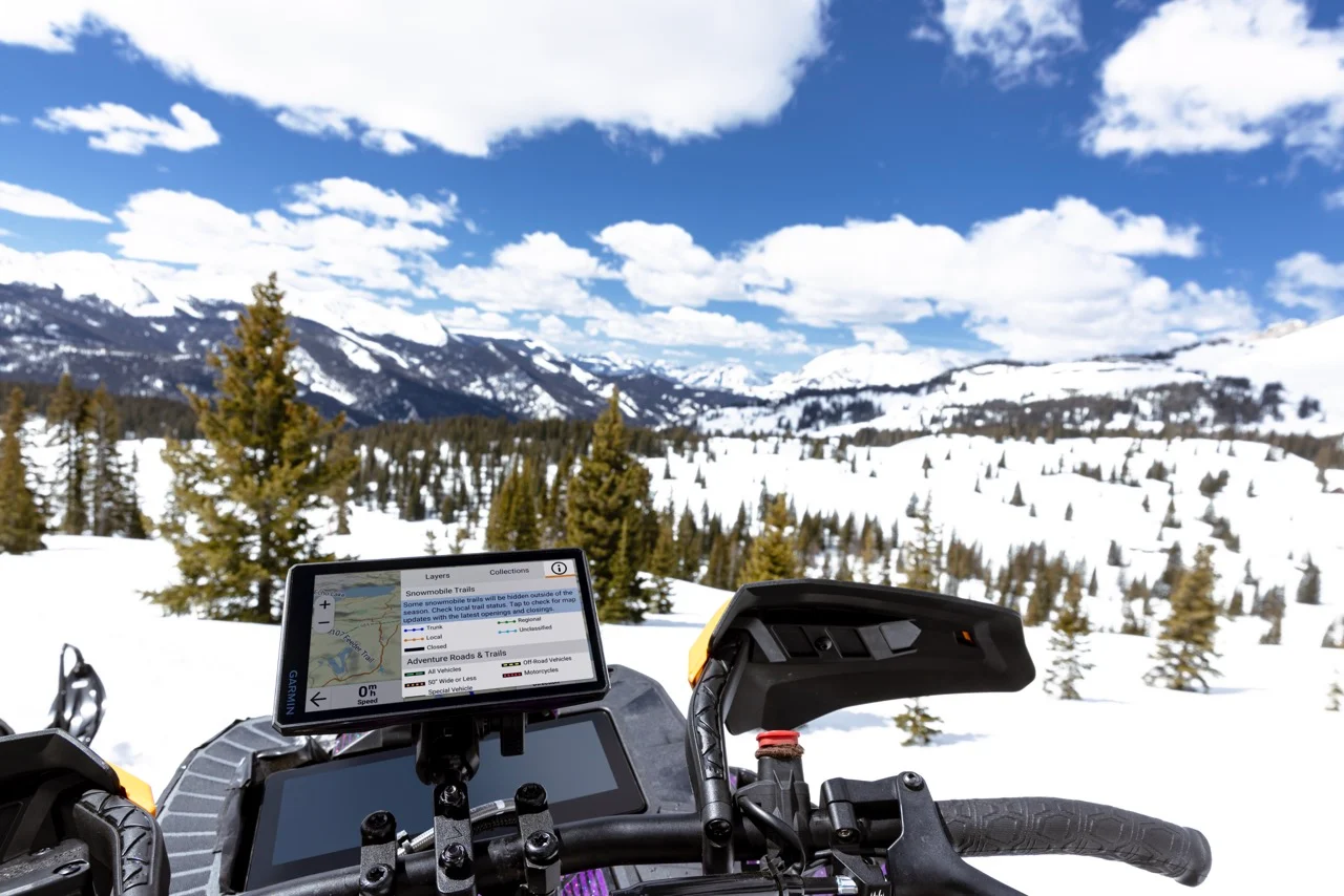
Rugged Design
Tread 2 brings adventure to life with a 6-inch high-resolution, ultrabright
display, which is easy to view in direct sunlight and easy to operate while
wearing gloves. It has an IP67 dust/water rating to withstand weather and
demanding terrain. Travel confidently across tough terrain using built-in
sensors that include an altimeter, barometer, compass and pitch/roll gauges.
Additionally, Tread 2 includes rugged roll tube and handlebar mount options to
best fit the setup of a wide range of powersport vehicles.
Superior Mapping
Tread 2 offers an incredible assortment of mapping features to help
adventurers push their limits and explore with greater confidence.
- Off-road mapping: Find the way with turn-by-turn navigation
for unpaved roads and trails with content from OpenStreetMap, U.S. Forest
Service Motor Vehicle Use Maps and Adventure Roads and Trails1.
- Maps for snowmobiles: Explore with preloaded topographic
maps, plus snowmobile-accessible trails and locations throughout the northern
U.S. and all of Canada.
- Satellite imagery: Download subscription-free satellite
imagery directly to the device via Wi-Fi technology to see high-resolution
overhead views of routes and terrain.
- Federal Public Land Boundaries: Be aware of public land
boundaries for national forests, Bureau of Land Management and wilderness areas
and view private land boundaries and landowner information for parcels greater
than four acres.
- Live updates: Use the Tread mobile app on a compatible
smartphone with an active cellular or Wi-Fi connection to access live weather;
share GPX files of favorite routes and track friends’ real-time locations using
the Group Ride2 mobile feature.
- On-road mapping: When the adventure stays on paved roads,
follow them with preloaded City Navigator maps of North America.
- Outdoor Maps+: Purchase a subscription to Outdoor Maps+ to
access premium map content, including slope angle, hunting data, avalanche risk
reports, and more.
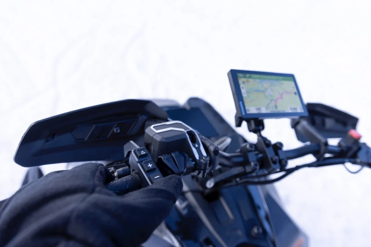
Control from the handlebar
Adventure-seekers can easily operate their compatible Tread or zūmo XT2
navigators with the new wired Handlebar Controller (sold separately). The
controller lets riders zoom in and out of their map view, select and scroll
through their preferred map layers, waypoints, control music and more. And the
intuitive push-button design makes it easy to operate the controller without
removing gloves or other gear.
The handlebar controller includes
versatile mounting options to fit most snowmobiles, motorcycles and ATVs. It can
also withstand adventurous rides with an IP67 dust and water-resistance rating,
while the wired power source ensures reliable performance in extreme
temperatures.
Working together
Riders can stay connected when venturing beyond cellphone coverage by pairing a
compatible inReach SOS satellite communication device3
for two-way messaging – which includes voice and photo messaging on select
devices – and location tracking via the 100% global Iridium satellite network.
In the event of an emergency, users can send an interactive SOS message to
Garmin Response, a 24/7-staffed international emergency assistance coordination
center.
Adventure seekers can also stay in touch with members in their
group by pairing Tread 2 with the Group Ride Radio for location sharing and
voice communication through the push-to-talk mic when exploring outside of cell
coverage. Additionally, it pairs with a Bluetooth enabled helmet or headset for
hands-free communication.
Available
now, the Garmin Tread 2 has a suggested retail price of $699.99,
while the new Handlebar Controller has a suggested retail price of $149.99.
1 Limitations may exist in map data for some road and trail route
suggestions. Always defer to posted road signs and conditions during vehicle
operation. Garmin products using OpenStreetMap data are intended to be used only
as supplementary travel aids.
2 Tracking via Group Ride Mobile
requires the Tread app running on each party’s compatible smartphone with
Bluetooth technology and an active cellular connection.
3 An active inReach subscription is required. Some jurisdictions
regulate or prohibit the use of satellite communication devices. It is the
responsibility of the user to know and follow all applicable laws in the
jurisdiction where the device is intended to be used.

