Santa Clara, Calif. (August 11, 2004) Thales announces the North American availability of the new Magellan eXplorist 100, the first GPS handheld to give navigators the confidence of knowing where they are within 10 feet for the highest level of accuracy at the low cost of US$99. The small, lightweight and easy-to-use Magellan eXplorist 100 is the ideal all-around recreational navigation device.
The Magellan eXplorist 100 offers the best value in a GPS track plotter for outdoor enthusiasts seeking adventures in hiking, climbing, camping, geocaching and more. Simple enough for first-time users, yet powerful enough for the GPS expert, the orange eXplorist 100 is built to provide real GPS for serious outdoor activities — with a tough, rubber-armored, impact-resistant, waterproof exterior and proven Magellan technology inside.
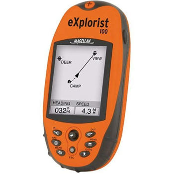
Magellan one-button access quickly takes users directly to the functions that matter most: the menu, personal points-of-interest storage, ‘goto’ routing, the backlight and the eXplorist 100’s three navigation screens with track plotting to help you find the fun — then find your way back. It also saves up to 500 waypoints and 20 routes, plus three track-log files with up to 2000 points each, providing ample storage space even for avid navigators.
Weighing less than four ounces and measuring only 4.6” x 2.1” x 1.3”, eXplorists are designed for fit-in-your-pocket convenience without compromising screen size. A large 2.3” diagonal, four-level grayscale LCD display has a zoom capability and amber backlighting to ensure optimum viewing, day or night. In addition, each eXplorist offers advanced capabilities, including Magellan TrueFix technology, which incorporates a superior 14-parallel-channel, WAAS/EGNOS-enabled GPS receiver to provide precise position fixes within three meters and ensure advanced reliability and accuracy in satellite signal acquisition and tracking.
The two other handhelds in the Magellan eXplorist series are the eXplorist 200 and eXplorist 300. The eXplorist 200, introduced in June, delivers a built-in North American background map plus all the features found in the eXplorist 100. In addition to accessing a map of roads, parks, waterways and airports, users can save up to five track-log files each with up to 2000 points. At US$149, the yellow-cased eXplorist 200 is available at a breakthrough price for mapping handhelds. The eXplorist 300, available in September, with its vivid blue housing, is the first handheld GPS to deliver a built-in nationwide background map of roads, parks, waterways and airports, plus a barometer, an altimeter and an electronic compass…all for under US$200.