Santa Clara, Calif. (October 4, 2004) Rounding out its Magellan eXplorist series of handheld GPS navigation devices, Thales announces the North American availability of its Magellan eXplorist 300. The easy-to-use, bright-blue Magellan eXplorist 300 is the first GPS handheld to deliver the convenience of a built-in nationwide background map, an electronic compass, altimeter, barometer and three-meter accuracy - all for just $199.
"The product marks a milestone in the GPS industry by delivering a combination of premium navigation features at an affordable price," said Christian Bubenheim, senior director of consumer product marketing for Thales' navigation business. "The Magellan eXplorist 300 is an ideal, easy-to-use navigation tool for outdoor adventures, including camping, hiking, hunting, geocaching, and more. Its powerful feature set will satisfy even the most hard-core enthusiast, while its intuitive interface makes it simple even for beginners to use."
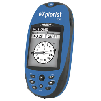
The compact Magellan eXplorist 300 weighs less than 4 ounces, measures 4.6" x 2.1" x 1.3," and has a rugged, rubber-armored, waterproof (IPX-7) exterior. Explorers can carry it anywhere with ease and use it in any weather condition. Navigation data is easy to see on the large 2.3" diagonal, high-resolution LCD screen. It's perfect for viewing the eXplorist's built-in North American background maps, complete with interstate highways, major roads, parks, waterways, airports, and more. In addition - and unique to the Magellan eXplorist line - the electronic compass of the eXplorist 300 eliminates the need to move to get a bearing, while its electronic barometer and altimeter allow users to monitor the weather and climbing conditions, respectively.
The Magellan eXplorist 300 offers fast one-button access to its most-often-used features: the menu, personal points-of-interest storage, "go-to" routing, backlighting and track-log screens, which let navigators automatically see where they have been. The eXplorist 300 can store up to 500 waypoints and five track-log files, each with up to 2,000 points. Its accuracy is ensured via Magellan TrueFix technology, which incorporates a superior 14-parallel-channel, WAAS/EGNOS-enabled GPS receiver to provide precise position fixes within three meters plus advanced reliability and accuracy in satellite signal acquisition and tracking.
The Magellan eXplorist 300 is the third in its series, and is preceded by the orange-cased Magellan eXplorist 100 and the yellow-cased Magellan eXplorist 200. The eXplorist 100, priced at only $99, offers navigators the best value in a GPS track plotter, combining easy-to-use features for the beginner with enough power for the expert user. The eXplorist 200 adds to those features a built-in North American background map and the ability to save up to five track-log files with up to 2,000 points each - all for $149, a breakthrough price for mapping handhelds.