Las Vegas, NV (January 5, 2005) Thales continues to rewrite the rulebook for handheld GPS as it announces today the CES debut of three additions to its breakthrough Magellan eXplorist line of compact, powerful, yet easy-to-use receivers. Complete with built-in mapping, the Magellan eXplorist 400, eXplorist 500 and eXplorist 600 are the first handheld GPS receivers to deliver PC-like file management, rechargeable lithium-ion batteries and a PC application designed specifically for transferring geocache information from the Internet to the eXplorist for the popular web-based outdoor activity called geocaching. These new eXplorist handhelds represent the definitive GPS guidance solution to meet the more diverse navigation needs of today’s consumer – both in the city and the outdoors. The complete Magellan eXplorist line of six receivers delivers more advanced features, more powerful performance, and more value than the competition, from just $99.99 to $449.99.
“In addition to offering the sought after features that have boosted the popularity of the Magellan eXplorist 100, 200 and 300 thus far,” said Christian Bubenheim, vice president and general manager for Thales’ consumer products, “the eXplorist 400, 500, and 600 introduce an all-new advanced set of features to the series, including being the first in their class to deliver unlimited SD card memory expansion with a built-in SD card reader/writer. The new handhelds also provide unlimited storage of waypoints, routes and track logs when using an optional Secure Digital memory card so that any available memory can be used to store whatever the users wants – a first in storage options that avid navigators will appreciate over limited waypoint, route and track log storage on other GPS receivers.”
Other firsts found in the eXplorist 400, 500 and 600 include:
The exclusive PC-style file management feature that allows users to create multiple files, folders and directories to store and maneuver through information in a PC-like structure.
The ability to calculate an area and perimeter simply by marking points on the map screen.
The Magellan geocaching manager software, a one-of-a-kind solution that simplifies geocaching, one of the fastest growing GPS applications so customers no longer need to print information from a website and manually entering GPS coordinates in a GPS receiver, but can load information to an eXplorist instead so its accessible where it’s needed most - to guide them to cache treasures.
All three models feature a high-speed USB data port to upload geocache coordinates and optional maps
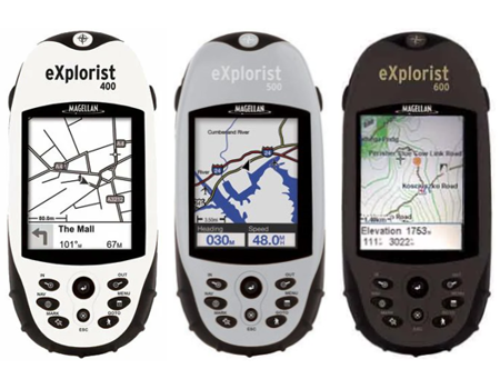
eXplorist 400: At $299.99, the white-cased, four-level grayscale eXplorist 400 delivers all of the major league GPS features above in a compact mapping unit, and is the first to do so at a $299.99 price point.
eXplorist 500: For those who want color GPS like no other, the eXplorist 500 delivers the advanced functionality of the eXplorist 400 plus a large color screen. At $399.99, it’s the most affordable color GPS available.
eXplorist 600: The eXplorist 600 rounds out the series with an unbeatable combination of features, including a color transflective TFT screen, a barometer, altimeter, thermometer and 3-axis electronic compass (which eliminates the need to be in motion to get a direction heading) – all for a breakthrough price of just $449.99.
While the eXplorist handhelds offer a variety of features to provide a complete set of solutions, all deliver a compact, waterproof housing IPX-7 at a weight of less than four ounces for fit-in-your-pocket convenience; a large 2.3” diagonal display; built-in maps of major roads, waterways, parks and airports; the ability to calculate vertical profiles for elevations of roads, trails and more; and a WAAS/EGNOS-enabled, 14-parallel-channel GPS receiver that delivers three-meter accuracy with fast, reliable position fixes.
The Magellan eXplorist 400, 500 and 600 are compatible with most Magellan MapSend software products for adding street detail, topographic data, marine navigation information and more, including the MapSend Topo 3D USA, MapSend Topo Canada and MapSend Lakes USA, MapSend Worldwide Basemap and MapSend DirectRoute, plus international titles. Other optional accessories include carrying cases, power adaptors, and mounting options for bikes, vehicles and more.