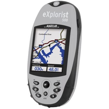
Santa Clara, Calif. (April 7, 2005) The handheld GPS navigation solution recreational enthusiasts have been waiting for is now available throughout North America. The Magellan eXplorist 500 is the most affordable and compact color handheld GPS and is the first handheld GPS with PC-like file management, rechargeable lithium-ion batteries, unlimited memory card expansion and exclusive geocaching software. A color GPS like no other, the Magellan eXplorist 500 is ideal for land and water navigation from biking, hiking and camping to hunting, fishing, and climbing, delivering breakthrough functionality and performance – all for US $399.99.
The Magellan eXplorist 500 provides a full-color, backlit, high-resolution, 2.3” diagonal display for clear day and night visibility of its built-in background map containing highways, parks, waterways and airports. The exclusive PC-style file management feature allows users to create multiple files, folders and directories to store and maneuver through information in a PC-like structure, while the built-in Secure Digital (SD) memory card reader/writer allows an expandable memory for unlimited storage of waypoints, routes and track logs when using an optional SD card. The Magellan eXplorist 500 operates on rechargeable lithium-ion batteries or an optional AAA-battery-backup clip.
The Magellan eXplorist 500 is also the first GPS receiver to calculate an area and a perimeter, and provides vertical profiles for trails and more. Another first is the included, one-of-a-kind Magellan geocaching manager software. This solution simplifies the fast-growing GPS activity of geocaching by eliminating the need to print information from a website or manually enter GPS coordinates into a receiver. Instead, the software loads data directly from the Internet to the Magellan eXplorist. With optional Magellan software, customers can also add street maps, topographical maps, marine navigation data and more. The unique interface allows users to load and access multiple programs on a single SD card, another first-time feature among handheld GPS receivers.
Compact, rugged and waterproof, the 14-parallel-channel, WAAS/EGNOS-enabled GPS receiver delivers three-meter accuracy, weighs less than four ounces and measures 4.6 x 2.1 x 1.3 for fit-in-you-pocket convenience. Preceded by the introduction of the Magellan eXplorist 100, 200 and 300 in 2004, the Magellan eXplorist 500 will soon be followed by the introduction of Magellan eXplorist 400 and 600 to round out the series. Optional Magellan eXplorist accessories include carrying cases, batteries, power adaptors, various mounting options and MapSend software, including MapSend DirectRoute, MapSend Topo 3D USA, MapSend Lakes USA, MapSend Topo Canada plus other international titles.