Santa Clara, Calif. (May 10, 2005) Now available throughout North America, the advanced Magellan eXplorist 600 color handheld GPS receiver boasts an unbeatable combination of features to appeal to the most savvy of outdoor adventurers. The Magellan eXplorist 600 offers a barometric altimeter, a barometer for gauging weather conditions, a thermometer and three-axis electronic compass, which eliminates the need to be in motion to gain a direction heading. Available at US$449.99, the eXplorist 600 equips hikers, hunters, boaters, geocachers and other outdoor enthusiasts with a multitude of tools to tackle any land or water navigation.
In addition to its three-axis electronic compass, barometer, barometric altimeter and thermometer, the Magellan eXplorist 600 is designed with other advanced features to simplify GPS navigation. It provides unlimited memory via an optional Secure Digital (SD) memory card; a high-speed USB data port for uploading coordinates and optional maps; plus an innovative PC-style file management system that allows users to easily create, store and manage multiple files, folders and directories of personal navigation data. The receiver also provides a one-of-a-kind tool to simplify geocaching, one of the fastest-growing GPS activities. The Magellan Geocaching Manager software allows users to easily load GPS coordinates directly from the Internet to the eXplorist 600. Other useful features include the eXplorist 600’s unique ability to calculate both an area and a perimeter, and its ability to deliver vertical profiles to simplify route planning. The eXplorist 600 operates on rechargeable lithium-ion batteries that last up to 17 hours, or with an optional AAA-battery-backup clip, which will be available this summer.
“I really enjoy the eXplorist 600,” said Bryan Roth, co-founder of Geocaching.com, after testing the newest Magellan handheld. “The form is extraordinary and the features, like vertical profiles, are especially valuable, particularly when traveling up a 4,400-foot mountain as I did on a recent excursion. The screen is beautiful, the satellite acquisition time is fantastic and the button functionality is, fortunately, the same as the other Magellan units with which I am happily familiar.”
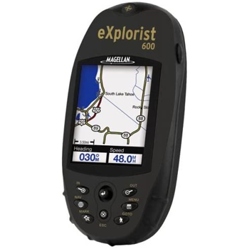
The WAAS/EGNOS-enabled, 14-parallel-channel GPS receiver delivers 3-meter accuracy and is packed with powerful Magellan TrueFix technology so customers can enjoy the freedom of exploring without worrying about getting lost. Navigators will see the difference the handheld’s large, 2.2-inch diagonal, 16-color, transflective TFT display delivers for the ultimate ease in viewing its four navigation screens in any lighting condition. The Magellan eXplorist 600 also provides 8 MBs of built-in maps with highways, parks, waterways and airports, plus 8 MBs of available internal memory, which holds up to 5 track logs, 20 routes and 500 points of interest. However, when using an optional SD card, customers can store an unlimited number of each and can also add detailed street maps, topographical maps and navigation data for lakes from optional Magellan MapSend software – all on a single memory card.
Rugged, compact and waterproof, the Magellan eXplorist 600 weighs 5.4 ounces with batteries and measures 4.7 x 2.2 x 1.3 inches. It is preceded by the eXplorist 100, 200, 300 and 500. The Magellan eXplorist 400 will round out the series when it becomes available this June. Optional Magellan eXplorist accessories include carrying cases, rechargeable lithium ion batteries, a AAA battery clip, power adaptors, various mounting options and MapSend software, including MapSend DirectRoute, MapSend Topo 3D USA, MapSend Lakes USA, MapSend Topo Canada plus other international titles.