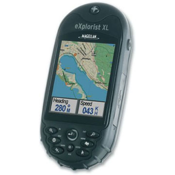
Santa Clara, Calif. (August 10, 2005) Thales’ navigation business, global provider of Magellan consumer GPS products, unveils its unique, new Magellan eXplorist XL handheld GPS receiver at the Outdoor Retailer show today. Available in September, the advanced, yet easy-to-use Magellan eXplorist XL ensures navigators can easily see where they’re going with the largest screen available on a rugged handheld GPS -- a 3.5”, sunlight viewable, high contrast color TFT LCD screen. It also delivers unlimited map storage with 30MB of available internal memory plus expandable memory through a built-in SD card reader/writer. The Magellan eXplorist XL’s enhanced capabilities offer exceptional versatility for camping, boating, fishing, hunting or driving.
“The versatility of the Magellan eXplorist XL gives adventure seekers and outdoor sportsmen the convenience and practicality of an eXplorist in a larger form factor,” said Christian Bubenheim, vice president and general manager for Thales’ consumer business unit. “The large color display screen builds on the variety of superior functionality consumers have come to equate with the Magellan eXplorist series.”
Measuring 6.4 x 2.9 x 1.3 inches, the water-resistant, Magellan eXplorist XL (US $449) delivers WAAS-enabled, 3-meter accuracy; a built-in base map of major roads, highways, parks, airports and waterways; plus the ability to store an unlimited number of waypoints, routes and track logs through SD-card memory expansion. Adding to its ease of use are its backlit keypad and joystick that provide one-touch access to key features and built-in help files. Its advanced PC-style file management system and high-speed USB data port allows users to easily download and access compatible Magellan MapSend mapping software so they can drive to a destination using MapSend DirectRoute software, then switch to MapSend Topo 3D USA to hike or hunt, for example.
The included Magellan Geocaching Manager software simplifies the fast-growing GPS activity by loading geocaching data directly from the Internet to the Magellan eXplorist to eliminate the need to print website information or manually enter GPS coordinates into a receiver. Also included is the new Magellan MapSend Software DVD, which makes it easier than ever for customers to take advantage of the power and advanced capabilities that MapSend maps add to their Magellan handheld. Customers receive free data management software plus the ability to purchase and install newly released versions of the MapSend line’s most popular software applications directly from the DVD. Customers can choose to activate complete applications of MapSend Topo 3D USA, MapSend Topo Canada, and/or MapSend DirectRoute North America with a credit card purchase from the Magellan website and install it using the DVD.
Optional Magellan eXplorist accessories include carrying cases, batteries, power adaptors and mounting options for vehicles, bikes and boats.