Salt Lake City, Utah (August 10, 2006) The affordable and compact, color Magellan eXplorist 500 LE handheld GPS is the first color handheld product in its class to offer a choice of AAA batteries or a rechargeable Li-ion battery pack.
Hikers, fisherman, climbers and kayakers can enjoy a complete navigation solution by combining with MapSend Topo 3D or MapSend Lakes. These bundles are offered at www.magellanGPS.com where customers can save up to 25% for the total solution, including a carry case.
Hiking Solution
The Magellan eXplorist 500 LE calculates an area and a perimeter while providing vertical profiles for trails and more. The unique interface allows users to load and access multiple programs on a single Secure Digital (SD) memory card. Using MapSend Topo 3D, hikers can hit the trails with a comprehensive view of contours, elevations, detailed terrain and extensive points of interest to find the sights and services along the way.
The rugged, convenient canvas carry case rounds out this solution by protecting the GPS while making it easy to clip to a belt, pack or other strap.
Kayaking or Fishing Solution
Magellan eXplorist 500 LE includes fishing and hunting times and a sun and moon calculator for any outdoor activity. With MapSend Lakes, this total solution delivers highly detailed Fishing Hot Spots and Lakemaster maps with shoreline and depth contours, bottom composition, aquatic vegetation, boat ramps and more. Extensive searchable points of interest make it easy to find the nearest services, marina, tower, beach, bait & tackle, fuel, amenities and all the fishing and kayaking information you need. MapSend Lakes USA software is included in this web bundle on pre-loaded, ready-to-use SD cards. Choose one of three U.S. MapSend Lakes regions for the West, North or South. The carry case is also included in the bundle.
Geocaching Solution
The eXplorist 500 LE features the one-of-a-kind Magellan geocaching manager. This solution simplifies the fast-growing GPS activity of geocaching by eliminating the need to print information from a website or manually enter GPS coordinates into a receiver. Instead, the software loads data directly from the Internet to the Magellan eXplorist. With optional Magellan software, customers can also add street maps. Includes MapSend Topo 3D and carry case.
eXplorist 500 LE for All Outdoor Activities
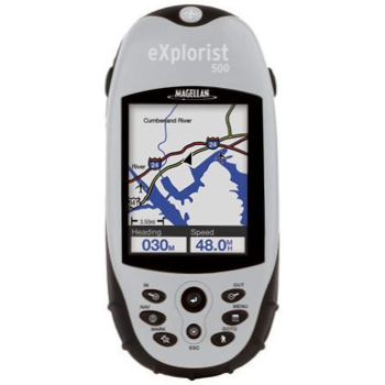
In addition, the eXplorist 500 LE features PC-like file management and unlimited memory card expansion. A color GPS like no other, it is ideal for land and water navigation delivering breakthrough functionality and performance. Compact, rugged and waterproof, the 14-parallel-channel, WAAS/EGNOS-enabled GPS receiver delivers three-meter accuracy, weighs less than four ounces and measures 4.6 x 2.1 x 1.3 for fit-in-your-pocket convenience.
The Magellan eXplorist 500 LE provides a full-color, backlit, high-resolution, 2.3” diagonal display for clear day and night visibility of its built-in background map containing highways, parks, waterways and airports. The exclusive PC-style file management feature allows users to create multiple files, folders and directories to store and maneuver through information in a PC-like structure, while the built-in SD memory card reader/writer allows an expandable memory for unlimited storage of waypoints, routes and track logs when using an optional SD card.
In addition to the MapSend software and carry cases included in the web bundles, optional Magellan eXplorist accessories include batteries, power adaptors, various mounting options and MapSend software, including MapSend DirectRoute, MapSend BlueNav XL3, MapSend Topo Mexico plus other international titles.