4 June 2009 @ 3:48 PM / Trail Tech /
| Of
the digital modes in use by Amateur
Radio operators, a popular one on 2m is the Automatic Packet Reporting
System (APRS). This unique system allows users to exchange data about what
is going on around them, including other users' positions, repeaters,
weather stations, ham fests, hospitals, emergency operations centers, search
and rescue teams, and more. To participate, most amateurs usually use three
pieces of equipment: a radio, a TNC or tracker (a specialized TNC with
specific support for APRS), and a GPS receiver with NMEA support. The
Colorado and Oregon require
a serial
data/power cable to
communicate with a tracker. For connection details, see the tracker's
documentation. The interface mode on the GPS unit should be set to NMEA
In/Out and waypoint output should be enabled on the tracker. After
connecting the radio to the tracker and tuning it to 144.390MHz (the APRS
frequency in North America), waypoints will start to appear on the Garmin
handheld.
|
|
 |
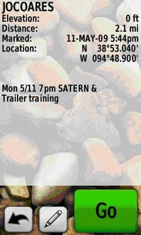 |
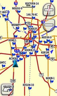
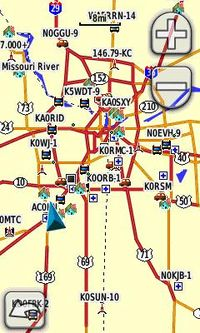
Seeing waypoints on a map presents a good spatial representation of people and objects relative to the device’s current position, but Garmin’s new Additional Waypoint Information NMEA sentence ($PGRMW) allows the tracker to update a waypoint's altitude, symbol and comment. In addition to a more effective visual presentation, waypoints (such as a training session) can now be updated with details that make them more useful (the date and time).
Currently, the Tracker2 from Argent Data Systems supports the $PGRMW sentence but we look forward to more device manufactures and hobbyists taking advantage of this added capability.
|