This new model offers
additional features including faster and more accurate orientation,
larger data and map memory storage, weather trends, WAAS/EGNOS
compatibility for positioning accuracy, a large display and an
ergonomic and robust design.
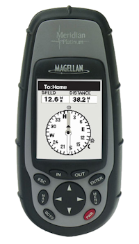
Las Vegas, NV – CES (January 7, 2002) Thales Navigation, a leading global provider of GPS equipment, with its Magellan and Ashtech product lines, today unveiled its new high-end handheld GPS receiver, the Magellan Meridian Platinum, at CES (Booth 11700 South Hall 3). Designed for those who want maximum functionality in a single device, the Meridian Platinum points the way, whether in the city, the wilderness or the middle of the ocean.
The Meridian Platinum, which will be available soon, guides the user to their destination with an accuracy of three meters or less, while also showing their location on an active map, integrated with a large 16 MB map database of U.S. streets. The new model also features a 3-axis electronic compass, allowing the user to determine their position and orientation more accurately and quickly; The Meridian Platinum is the first GPS receiver on the market to use Secure Digital Memory Card (SDMC) technology for increased memory size, giving the user the ability to store more or larger maps and other useful data on their device.
“The Meridian Platinum is both the most sophisticated and easiest to use GPS on the market, giving the user almost immediate access to road and highway maps, maps of nature parks, rivers, urban centers and much more,” said Lonnie Arima, vice president of the “International Marketing and Sales” division at Thales Navigation. “The Platinum user also has weather information thanks to the barometer it is equipped with; Its 3-axis electronic compass also lets it know which direction to go even when it's stationary and even if the device is not parallel to the ground.”
The Meridian Platinum's expandable memory gives the buyer an unprecedented level of functionality: the user can download up to 64 MB of data at a time from Magellan's MapSend software, which contains street maps, topographic data and useful travel information for the United States, Canada and Europe.
With its large, backlit, grayscale graphic display, the Meridian Platinum user can view their position on seven highly readable positioning screens. Its 12-channel parallel quadrifilar helix antenna ensures the best possible reception of satellite signals and very fast position fixes, while the use of satellite correction signals from WAAS/EGNOS systems ensures the user the highest accuracy. The user can also store up to 500 waypoints and 20 reversible routes in memory, allowing them to return to their favorite places as many times as they like. An ideal travel companion, the Platinum is available in nine different languages, fits in your pocket and weighs 227 grams; Its ergonomic casing is robust, non-slip, waterproof and unsinkable.
To meet the diverse needs of its customers, Magellan's Meridian series of devices also includes the Meridian GPS, Meridian Gold and Meridian Marine. Optional accessories include swivel, vehicle and bicycle mounts, PC cables and a canvas case. Meridian receivers are also compatible with Magellan's MapSend software, including MapSend Streets and Destinations (USA), MapSend Streets Europe and MapSend Topo for the United States.