Marine Chart Mode
- Select the type of chart the device uses when
displaying marine data
-
Off
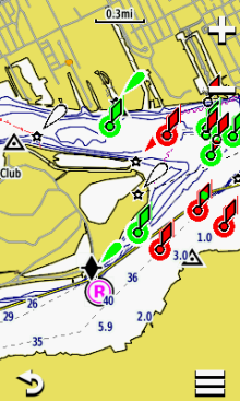
- Nautical
(Displays various map features in different colors so marine POIs are
more readable, reflecting drawing scheme of paper charts)
-
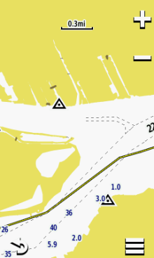
Fishing (Simplifies map presentation for optimal viewing of bottom contours and depth soundings, requires marine maps)
-
Examples shown with LakeVu HD and Worldwide Basemap
enabled:
Appearance
- Sets the appearance of marine navigation aids
on the map
- Spot Soundings
-
Light Sectors
-
Symbol Set
-
Safety Shading
Marine Alarm Setup
- Sets alarms for exceeding a specified
drift distance while anchored, when off course by a specified distance, and when entering water of specified depth.