Maps
- The inReach Explorer+ is equipped with 2
GB of internal map memory.
- Devices that are preloaded with regional
mapping will have less available map memory.
- Traditional Garmin maps are not compatible
with the inReach Explorer+.
Available Map Products
- Preloaded Maps
- Topo North America
A high detailed topographic dataset with
features such as contours with elevation, geographic locations, place
names, landmarks, points of interest, hydrographic features, and
land-use/land-cover detail. Map detail is consistent and coverage in
rural areas is unparalleled. Scale detail is equivalent to 1:24,000
data, similar to what is seen on a USGS Topo Quad. [USGS Map Legend]
- OpenStreetMap
OpenStreetMap (OSM) is a community developed
mapping dataset, developed, maintained and added to by community mappers
around the world. In densely populated areas of the world OSM is a
highly detailed dataset. In many rural areas of the world OSM has medium
to low detailed data. Features are added and edited by community members
with local knowledge. Coverage of features may vary and include
geographic locations, place names, landmarks, points of interest,
hydrographic features and land-use/land cover. OSM is an open data
source. An open data source elevation dataset is also included. Because
the OpenStreetMap data is Volunteered Geographic Information, scale
detail is not consistent. Scale detail can vary from 1:24,000 or better
in major urban areas to 1:1 million in more rural areas. [OSM Map Legend]
- Digital Atlas of the Earth
The Digital Atlas of the Earth (DAE) is a
medium detailed complete, seamless global dataset, and includes all the
world’s continents and countries, providing a consistent level of detail
and reliable horizontal accuracy for features worldwide. The DAE
includes major transportation layers, inland and shoreline hydrography,
agreed and disputed jurisdiction boundaries, place names, major
topographic features including contours with elevation, and land-use or
land-cover detail. This data is topological, routable, and GPS
navigable. Also available for the United States, Canada and Mexico for
medium detailed data and/or if available memory is a concern. Scale
detail is equivalent to data seen on a 1:125,000 map. [Road Map Legend]
- Public Lands
Lands held and maintained by the United States Government in trust. Examples of lands included are Bureau of Land Management, Bureau of Reclamation, and State Trust Lands.
- Public Land Survey System
Public Land Survey System (PLSS) is a subdivision and description of land in the United States based on a rectangular system of surveys.
Typically, the land is divided into 6-mile square townships. The townships are divided into 36 1-mile square sections. Available in most states.
- Game Management Units
Areas or units defined by each state used to regulate and define hunting boundaries by either species or seasons, or by both species and seasons.
- Parcels
Areas identifying land ownership, specific to private lands, derived from written deeds and surveys and often maintained by municipalities and/or state governments.
Some public lands included. Owner name and address not always available. Coverage may vary.
Installing + Removing Maps
- Login to your
Garmin Explore account.
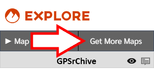
- Open the Map
tab.

-
Select Get More Maps.
- This option is only available for
accounts with an inReach Explorer+ assigned to them.
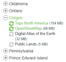
- Make desired maps selections from
available lists.
-
 Map is pre-installed and can not be changed.
-
 Map will be installed on the device after the next sync operation.
-
 Map will not be installed on the device after the next sync
operation.
Map will not be installed on the device after the next sync
operation.
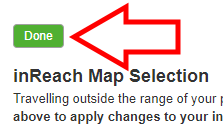
- When map selections are complete, select
Done at the top of the page.
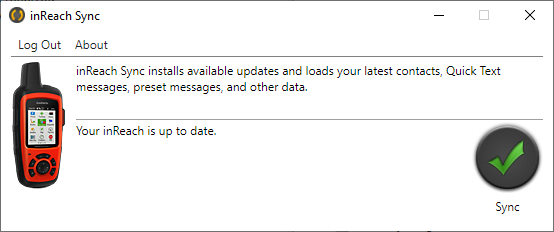
- Connect your inReach Explorer+ via USB and
run
inReach Sync to add + remove selected
maps.
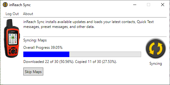
- The inReach Explorer+ will restart after
the sync process is complete.

