|
Get the powerful, expandable mapping pocket-sized GPS. The
Magellan eXplorist 400 features mapping capabilities and
unlimited storage via optional secure digital (SD) cards so you
can take as many maps with you as you want to. Add detailed
street maps, topo or lake maps using optional Magellan MapSend
software. The high-speed USB data port makes downloading
information easy and the Geocache Manager software enables you
to download caches directly to your eXplorist 400. eXplorist 400
has 8 MB of built-in maps and 8 MB of internal memory to save 5
track log files, 20 routes and 500 points of interest, but you
can save as many as you need to optional SD cards.
Slip
your compact (2.1 in x 4.6 in) eXplorist 400 into your pocket
and let it guide you on every outdoor adventure. Magellan
TrueFix technology provides superior accuracy and reliability,
giving you the freedom to explore without concern of getting
lost.
Unlimited SD Card Expandability
Your eXplorist 400 features SD card compatibility for unlimited
memory expansion. Use optional Magellan MapSend software to add
detailed street maps, topo or marine charts to any number of SD
memory cards (sold separately).
USB data port
Transfer map data from your PC to your eXplorist 400 with
the high-speed USB data port.
Area Calculation
Want to find the distance between three or more points of
interest that you plan to hike around or the area between them?
Simply select the points of interest on the map and the
eXplorist can determine the area between them and the perimeter
around them.
Li-Ion Rechargeable Battery
This Li-Ion rechargeable battery pack can keep your
eXplorist continuously powered-up for up to 14 hours. Recharge
your battery directly through your receiver again and again
without reducing its performance.
TrueFix
Technology - Accurate & Reliable
TrueFix GPS
technology takes advantage of 14 parallel channels, supported by
WAAS and EGNOS Satellite-Based Augmentation Systems for fast
signal acquisition, minimal signal loss and reliable accuracy to
within 3 meters.
Geocache Manager
Download Geocache coordinates from Internet sites and use
them on your outdoor adventures. This unique feature makes
managing coordinates even easier with a PC-style file system.
You don't have to be a geocacher to appreciate the Magellan
Geocache Manager.
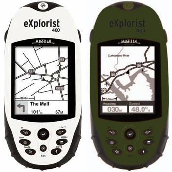
Built-in mapping
With 8 MB of built-in North American or European maps it's
easy to navigate around roads, parks, waterways and to find
airports and other points of interest.
Easy-to-use
One-button access takes you directly
to all of the most important features. Intuitive operation with
keypad and joystick control adds even more fun to GPS
navigation. First-time user can easily navigate with the
eXplorist 400.
Languages
No
matter your language, there's a good chance the eXplorist speaks
it. Choose from English, French, German, Spanish, Italian,
Swedish, Finnish, Portuguese, Dutch or Norwegian.
Track Logging
Store up to 5 track log
files, each with 2000 track-points to the internal memory and
store an unlimited amount of track log files to optional SD
cards, to easily find your way to your favorite spot again and
again.
Four navigation screens
View speed, direction, distance to destination and all the GPS
information you need on 4 easy-to-read navigation screens.
No service fees
Your eXplorist 400
is ready to go with no service fees and no activation fees, so
go ahead, use it all the time.
Satellite status
Monitor the GPS satellites tracking your position and get
information about their status.
Pocket-sized
Don't let the size fool you. eXplorist 400 is packed with
real GPS power and cool features. But at 2.1" x 4.6" x 1.3" and
only 5.4 oz you can take it anywhere.
Large
backlit display
Easily view all the GPS
information you need to make your adventure fun and safe, even
at night. The amber glow of the backlight protects your vision
at night so you can see both your eXplorist and the path in
front of you.
Rugged construction
Rubber armored, impact resistant plastic lets you to
confidently take your eXplorist 400 on every adventure.
Waterproof
eXplorist 400 is sealed to
IPX-7 specifications, you don't have to worry about getting it
wet.
Wilderness Bundle
Looking for a neat
one-package solution for outdoors navigation? Check out the
Magellan eXplorist 400 Wilderness Bundle. You get a
limited-edition green eXplorist 400 with all the power cords and
cables, the outstanding Magellan MapSend Topo 3D USA software, a
blank 32MB flash memory card, and a belt clip carrying case.
Warranty
We pride ourselves
on building rugged and reliable navigation products that you can
depend on, backed by a full one-year warranty in North America.
|