 |
|
|
The Magellan eXplorist 310 GPS receiver comes packed
with tons of helpful features and is ready to use right out of
the box. The eXplorist 310 is pre-loaded with the World Edition map, which includes a complete road network in the United States, Canada, Western Europe, and Australia and major roads throughout the rest of the world. This unique preloaded map also includes water features, urban and rural land use, and city centers. Regional versions of Magellan’s Summit Series topographic maps are available for download to expand mapping coverage and level of detail. |
||
|
A vibrant, transflective
color screen allows for the best readability in direct sunlight.
To zero in on the exact location of a geocache, favorite fishing
spot, or the next summit, the SiRFstar III GPS chipset provides
accuracy of 10-15 feet (3-5 meters). To keep your outdoor
adventure going all day long, the device is powered by two AA
batteries for 18 hours of constant usage. The eXplorist 310 is
rugged, waterproof, and submersible (IPX-7). All of this is
packed into a small and attractive handheld form factor that can
be hung around your neck with the optional Magellan lanyard or
attached to your pack with the built-in carabineer hook. The eXplorist 310 provides unmatched assistance with navigation, such as the combination of the world’s two most useful navigational tools – a compass and a map! Overlay a series of different transparent compass styles on top of a pre-loaded worldwide map that show roads, water features, parks, and city centers. Access the dashboard screen to show a mini-compass for quick reference and customizable navigation data fields, such as latitude, longitude, heading, bearing, distance to end, trip odometer, and many more. Go back to the map screen and view your active track, which is a series of digital breadcrumbs to record all yours movements. Mark your starting point (car, trailhead, parking lot…) with a waypoint and easily navigate back to that location at the end of the day. The eXplorist 310 supports paperless geocaching, which allows you to download more than 20 unique characteristics of each cache, including name, location, description, hider, size, difficulty, terrain, hint, spoilers, attributes, and last 20 user logs among a number of other details. |
|
|
Reference your track summary
to keep track of your distance travelled, elevation gained or
lost, complete travel time, moving time and stopped time, and
average time to find. Easily reset your track summary statistics
to track the details of your next geocaching adventure. No matter where you enjoy the outdoors, the eXplorist 310 GPS receiver will provide precise GPS signals thanks to the Satellite Based Augmentation Systems (SBAS) of WAAS, EGNOS, and MSAS; display coordinates in a myriad of different global systems, including UTM and WGS84; and accurately guide you to and from your next adventure, where ever in the world that may be! |
||
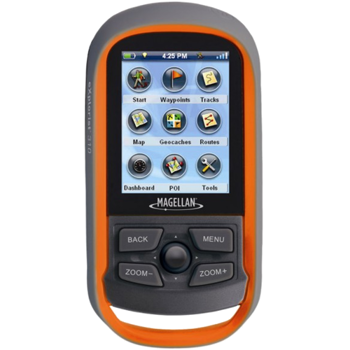
A simple main menu, intuitive contextual menus, and vibrant graphics make this device easy to use.
Brilliant, sunlight readable color screen
A vibrant 2.2” color transflective screen provides the best readability in direct sunlight.
Rugged and waterproof to IPX-7 standards
Focus on the adventure not protecting the device.
High-sensitivity SiRFstar III GPS with 3-5 meter accuracy
3-5 meter GPS accuracy provides a superior navigation experience.
Pre-loaded World Edition Map
Referencing a complete road network in North America and Western Europe and major roads throughout the rest of the populated world to help in orientation. See parks, rivers, lakes, major city points, and other types of land use areas.
18 Hours of battery life using 2 AA batteries
Go strong for an entire day (or more). No stopping to replace the batteries.
Suspend Mode
The goal is to conserve battery life by putting the device into an advanced power saving mode. Suspend mode will turn off everything expect for GPS tracking. Wake up the device with a single click.
Paperless Geocaching
Download and view more than 20 unique characteristics of each cache and view, search, filter on the device. Details include name, location, description, hider, size, difficulty, terrain, hint, spoilers, and last 20 user logs among a number of other details.
500 megabytes of user memory available
Loads of space to store additional maps, geocaches, waypoints, and tracks.
Record Tracks and See “Breadcrumbs” on the Map Screen
Keep a log of all the steps you took throughout the day. Reference your track to find your way back or to keep a digital journal of all your outdoor adventures.
Track Summary
Start your journey with one-click and keep tabs on useful statistics such as distance travelled, average speed, elevation gain and descent, and average time to find.
NMEA Message Output (USB Only)
For hardcore outdoor GPS enthusiasts who want to connect their device to laptop running VantagePoint software and see your position on computer screen.
Multiple Coordinates and Map Datums
Navigate around the world and do it accurately. See your geographic location in UTM coordinates or reference the OS Grid for use in Great Britain.
- Corrections to Japanese Keyboard.
- Corrections to Japanese translation issues.
- Fixed an issue with missing contour lines on some maps.
- Fixed Trans Mercator issue for user defined grids.
- Fix issue with UTM shows 'N/A' for coordinate south of N10.00000 deg.
- Fix issue with select/unselect FHS Maps.
- Fixed Area Calculation issue where the last leg was not included.
- Fixed issues with Japanese keyboard.
- Translation Update.
- Fixed NZ grid issue.
- Added support for Fish & Hotspot Maps.
- New keyboard layout for easier text entry.
- Change auto-zoom default to OFF.
- New popup message that informing the user that a waypoint was created when the joystick was pressed/held.
- Moved NAD27 CONUS to the top of the datum list (under WGS84).
- Waypoint/Geocache default for Favorites is set to "All".
- Contextual menu improvement.
- Removed ability to inadvertently delete pre-loaded maps.
- Improved Area Calculation function.
- Fixed coordinate display issues.
- Renamed "Proximity Alarms" to "Alarms".
- Provided GPX format for Active Track when device is connected to a PC.
- New Smart Arrow.
- Added "Next Waypoint" to "Data Fields".
- Various bug fixes.
- Corrected how device displays coordinate information for UTM, MGRS and OSGB.
- Added "Portuguese - Brazil" language.
- Updated Polish and Czech translation.
- Fixed coordinate entry reset bug.