 |
|
Alaska tested and built for the hunt the Magellan eXplorist
350H is the Outdoor GPS specifically designed for the Hunter.
The "H" in 350H stands for Hunt and this eXplorist device is
built from the ground-up to be the perfect tool to help before,
during and after the hunt.
Magellan’s eXplorist 350H
comes ready to use with an interface designed to be simple and
give a hunter access to the features needed as quickly as
possible.
The 350H is also equipped with housing that is
rugged, waterproof and submersible (IPX-7). The ergonomic
housing comes in a camouflage pattern and the orange highlights
help the device standout if accidentally dropped.
Before
the Hunt start the one year free subscription to DigitalGlobe
provided in the package. Use the satellite imagery from
DigitalGlobe to pre-scout your hunting grounds. Download the
detailed imagery to your PC and you can identify glassing
locations, tree lines or game funnels. Once you have identified
certain areas with features beneficial to a successful hunt
download them into your 350H.
The eXplorist 350H includes
a calendar to identify the best days and time to hunt based on
moon phases and solunar positioning. Sunrise and sunset times
are also available to help plan your hunt.
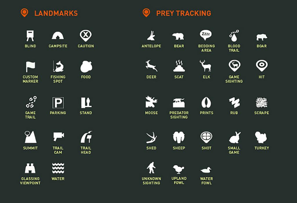
As you enter your hunting grounds use the over 30 hunt specific waypoints to mark animal tracks, trail camera locations and build a database of what is happening in your hunting area. No more typing out names; use the waypoint icons to mark streams, bedding areas, food sources, game tracks and more.
In addition to DigitalGlobe satellite imagery the 350H includes a detailed base map with contour elevation overlays showing roads, trails, water bodies and identifies terrain features for easier navigation in the backcountry.
The eXplorist 350H comes with pre-loaded GMU’s and WMU’s to help you stay within legal hunt borders. Through the 350H’s easy to use and customizable interface set up your hunting zone and configure the device to notify you when and how you prefer. Avoid the costly mistake of hunting outside your legal zone.
The 350H comes jam packed with all the traditional features expected from a Magellan eXplorist GPS device.Those features are a 2.2” color transmissive screen for rich graphics and readability in direct sunlight, 18 hours of battery life supplied by two AA battery's (included), suspend mode to give you even longer battery life while maintaining GPS tracking, compass overlays, and high sensitivity SiRFstar III GPS chipset providing accuracy to 3-5 meters, and record tracks with breadcrumbs to find your way back to your campsite, blind or vehicle.
No matter where your hunt may take you the Magellan eXplorist 350H is ready for the adventure ahead.
Built for the Hunt – Tough, rugged and waterproof camouflage casing built to take abuse in the back-woods.
Hunting Waypoints – Build a database of your hunting grounds with over 30 unique waypoints for marking trail cameras, terrain features, animal tracks and more.
Free 1 year subscription to DigitalGlobe – Pre-scout your next hunting trip in advance with the help of DigitalGlobe satellite imagery. Identify game funnels, bodies of water, potential bedding areas and vantage points before leaving home.
Pre-loaded Hunt and Topo Maps – Detailed base map with complete road network with water, land use and city centers + layered contour elevation map to identify terrain features.
Hunting Border Alerts – User configurable notifications help you stay within hunt boundaries or zones by geo-fencing your particular hunting grounds using GMUs and WMU’s. Avoid hunting outside your legal hunt zone.
Brilliant, sunlight readable color screen - A vibrant 2.2" color transmissive screen provides the best readability in direct sunlight.
Rugged and waterproof to IPX-7 standards - Focus on the hunt, not protecting the device.
High-sensitivity SiRFstar III GPS with 3-5 meter accuracy - 3-5 meter GPS accuracy provides a superior navigation experience.
Up to 18 Hours of battery life using 2 AA batteries - Go strong for an entire day (or more). No stopping to replace the batteries.
Suspend Mode - The goal is to conserve battery life by putting the device into an advanced power saving mode. Suspend mode will turn off everything expect for GPS tracking. Wake up the device with a single click.
Up to 500 megabytes of user memory available - Space to store additional maps, waypoints, and tracks.
Record Tracks and See “Breadcrumbs" on the Map Screen - Keep a log of all the steps you took throughout the day. Reference your track to find your way back or to keep a digital journal of all your outdoor adventures.
Track Summary - Start your journey with one-click and keep tabs on useful statistics such as distance travelled, average speed, elevation gain and descent.