 |
|
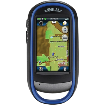
| Rugged and waterproof (IPX-7), the eXplorist 510 combines high sensitivity GPS reception with easy to read mapping and accurate navigation. Find your way using more than 30 navigational data fields. Create waypoints, record tracks, and route from point to point. The integrated 3.2 mega-pixel camera, microphone, and speaker enable outdoor enthusiasts to record geo-referenced images and voice notes. Relive your outdoor adventures on the device, on your computer, or share with others on various online communities like geocaching.com. | ||
| Enjoy
paperless geocaching with the eXplorist 510. Download and view
more than 20 unique characteristics of each cache and view,
search, filter on the device. Details include name, location,
description, hider, size, difficulty, terrain, hint, and recent
logs created by other geocachers. The eXplorist 510 packs the most accurate maps into the palm of your hand. The World Edition map allows for 2D or 3D viewing angles. It includes a complete road network in United States, Canada, Western Europe, and Australia and major roads throughout the rest of the world and provides cartographic orientation in almost any location. This unique, preloaded map also includes water features, urban and rural land use, and a realistic shaded relief background. The best of both worlds, the eXplorist 510 combines the user friendliness of a touch screen with the reliability of two customizable hard buttons. Program the hard buttons to your two favorite or most used functions. Powered by two AA batteries, the eXplorist 510 will last up to 16 hours under normal conditions. To help conserve power, use the suspend mode to turn off the device but maintain GPS tracking. You can also adjust power management settings to your preference. Magellan's award winning OneTouch favorites menu is now on our handheld devices. It provides instant access to bookmarks of favorite places. Set your home, base camp, and car. Easily re-assign a new location for each new adventure. 12 customizable icons to create personalized searches, save unique locations, or assign quick access to your favorite screens. |
||
Rugged and waterproof, the eXplorist combines high sensitivity GPS reception with aesthetic mapping and accurate navigation. Find your way using more than 30 navigational data fields. Create waypoints, record tracks, and route from point to point.
Experience Recording
Integrated 3.2 mega-pixel camera, microphone, and speaker enables outdoor enthusiasts to record geo-referenced images and voice notes. Relive your outdoor adventures on the device, on your computer, or share with others on various online communities.
Superior Maps with 3D Perspective View
The eXplorist series packs some of the most accurate maps into the palm of your hand. The World Edition map allows for 2D or 3D viewing angles and covers the globe with details roads and land use areas. Summit Series is a new breed of topographic outdoor maps covering various regions with high level of detail. City Series will add turn-by-turn routing to your handheld GPS receiver.
3.0" Touch Screen and Button Controls
The best of both worlds, the eXplorist combines the user friendliness of a touch screen with the reliability of two customizable hard buttons. Program the hard buttons to your two favorite or most used functions.
Paperless Geocaching
Download and view more than 20 unique characteristics of each cache and view, search, filter on the device. Details include name, location, description, hider, size, difficulty, terrain, hint, and recent logs created by other geocachers.
16 Hours of Battery Life
Powered by two AA batteries, the eXplorist 510 will last up to 16 hours under normal conditions. To help conserve power, use the suspend mode to turn off the device but maintain GPS tracking. You can also adjust power management settings to your preference.
OneTouch Menu
Magellan's award winning OneTouch favorites menu is now on our handheld devices. It provides instant access to bookmarks of favorite places. Set your home, base camp, and car. Easily re-assign a new location for each new adventure. 12 customizable icons to create personalized searches, save unique locations, or assign quick access to your favorite screens.
World Edition Pre-loaded Map
The World Edition includes a complete road network in United States, Canada, Western Europe, and Australia and major roads throughout the rest of the world that provides cartographic orientation in almost any location. This unique preloaded map also includes water features, urban and rural land use, and a realistic shaded relief background.
- Added support for multiple hardware configurations.
- Corrections to Japanese translation issues.
- Fixed an issue with missing contour lines on some maps.
- Fixed Trans Mercator issue for user defined grids.
- Add Japanese and Korean languages.
- Fix NZ grid issue.
- Fix Magmatic/True North issue.
- New GPS firmware to fix Active Suspend issue.
- New OS & Drivers.
- FHS Map Support.
- Leap Year Fix.
- Added Brazilian-Portuguese language.
- Added Turkish language.
- Languages update.
- Fix issue with device won't start properly because of corrupted unit.xml file.
- Fix issue with Geocache list not showing closest cache from Geocache hard button.
- Fixed system freeze issue.
- Resolved security issue for maps SD Card.
- Added Navionics Marine Chart support, Navionics GOLD charts, Hotmaps, and Fish'N Chip.
- Added 'Depth' to Navigation Field List. Only available if Navionics Chart is active.
- Added ability to change scale in Road Compass page and improved functionality.
- Fixed issue with missing Geocache log.txt file.
- Fixed issue with Geocache List shows 'Error' msg.
- Added Up/Down Arrows on contextual menu.
- Removed the ability to delete pre-loaded maps (World Edition, Summit Series, City Series) from the device.
- Improved area calculation function. View area statistics while moving instead of viewing the information afterward.
- Improved performance of back light settings.
- Improved performance of suspend functionality.
- Additional functionality for the customizable hot key:
- Marking a waypoint is now a one-click function.
- Geocache Details button added.
- While in route to a geocache, the button will toggle from current screen to geocaching details and back to last screen.
- When not routing, the button will search for the nearest geocache based on user defined search criteria.
- Improved waypoint functionality. When creating a waypoint, the same name and icon will be used for subsequent waypoints with the exception of an incremental number. For instance, Trailhead 1, Trailhead 2, and so on.
- Improved map display:
- Improved active and saved track display options
- Improved the color of contour lines within various land use areas to improve visibility.
- Added ability to inspect the names of user generated objects, such as saved tracks.
- Resolved issue where National Parks sometimes overlap contour lines and shaded relief background.
- Cities are now displayed on the map screen.
- Improved heading and bearing functionality on several screens, including compass screen.
- Added UP/DOWN arrows on all list screens that extend beyond one page.
- The active track is now converted automatically to a .GPX file when the device is connected to a computer.
- Improved performance of alarm clock feature.
- After marking a geocache as found, the user will be prompted to route to nearest unfound cache.
- Auto Zoom is now set to OFF by default.
- "Recalculate Position" feature will now update the position of a waypoint to your current location.
- When a .GPX file contains a track name in the proper location, the name will be imported into the eXplorist User Interface.
- For example, if the track is named "Pacific Coast Trail", then the name will appear in the track list and track details.
- If the track name is not present, it will show as blank or "TRK1".
- When entering an address as a destination, the routing method will default to turn-by-turn (requires City Series map).
- The date & time stamps of .GPX files is corrected.
- Resolved issues with proximity alarms.
- Spoken turn-by-turn directions are resolved for Spanish languages (requires City Series map).
- Added Portuguese language.
- Improved language translations.
- Coordinate systems improvements:
- Corrected Ireland 1965.
- Corrected Swedish Grid conversion error.
- Added ability to enter coordinates in SWE99 datum.
- Swedish Grid RT90 and SweRef99 TM both work properly now.
- Improved Software Performance.
- Resolved Media Issue Where Users Were Limited to Capturing 700 Images.
- Improved Barometric Altimeter Calibration.
- Resolved Issue with “Degree/Minute/Second” Coordinate Entry.