|
|
|
|
|
|
|
|
|
Overview |
|
|
|
Rugged, Reliable GPS with Maps and Aerial Imagery
Included |
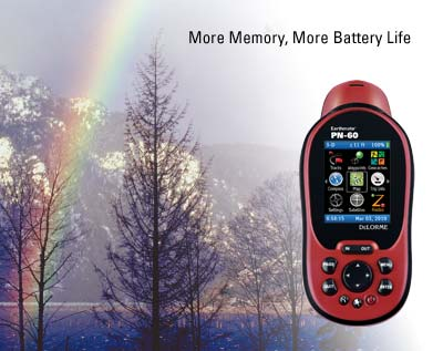 |
- The rugged, reliable Earthmate PN-60 delivers
next-generation GPS capabilities, plus DeLorme's
market-leading map and aerial imagery displays.
- DeLorme Topo North America desktop software and GPS maps
are included, with comprehensive detail for all your
favorite outdoor activities.
- Aerial imagery, nautical charts, and supplemental USGS
and Canada topo maps are also available.
|
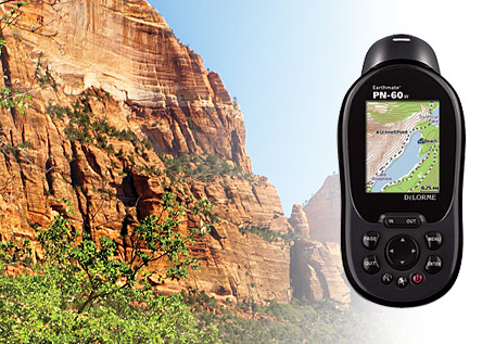 |
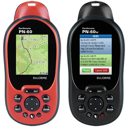
- Navigate worry-free anywhere you go with the waterproof,
impact-resistant PN-60w.
- Its high-end GPS features and
unrivaled selection of included maps, aerial imagery, and
boating charts are ideally suited for use on land or water.
- The PN-60w also enables 2-way satellite text messaging
and interactive SOS when paired with a DeLorme inReach.
- No other GPS offers such a broad array of navigation and
communication solutions.
|
|
|
|
Premium GPS features |
- Enjoy blazing-fast-performance with high-sensitivity
32-channel chipset and dual-core processor
- Daylight readable 65k color screen lets you read the
PN-60 in any light conditions
- Determine direction while stationary with
tilt-compensated 3-axis electronic compass
- Determine precise elevations with sensitive barometric
altimeter
- Save waypoints and tracks as .gpx files, to internal
memory or to SD cards, with no maximum limits
- Store all the maps and aerial imagery you need with 3.5
GB of internal memory and support for SD cards up to 32 GB
- Extend battery life with power management features
|
|
|
|
Navigation |
- Plan your trips and find your way with included Topo
North America software and GPS maps for the U.S. and Canada
- see below
- Use the free MapPack subscription to add official USGS
and Canada government topo detail, U.S. aerial imagery,
- Enjoy WAAS-enabled accuracy to within 10 ft.
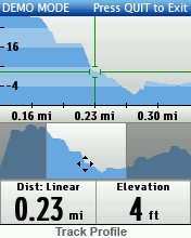
- View cutaway elevation profiles with your position
pinpointed
- Generate road and trail routes automatically on the
included Topo North America software for transfer to the
PN-60
- Use PN-60 onboard routing function to create "on the
fly" road routes
|
|
|
|
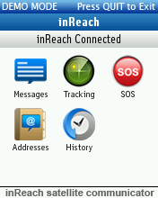
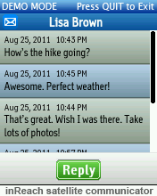
Communication (PN-60w) |
- Take advantage of 2-way
satellite text messaging when there's no cell phone
coverage or in lieu of bringing your cell phone into
rugged environments
- With delivery confirmation,
you'll never have to wonder if your message was
received
- Send descriptive,
interactive SOS messages so responders can prepare
accordingly; maintain communication with Response
Center for mutual updates
- Enable remote tracking,
letting anyone you designate follow your travels
online
- Stay connected wherever you
go on land or water, from pole to pole
- Communication enabled when
PN-60w is paired with DeLorme inReach; communication
features require subscription
|
|
 |
|
|
|
|
|
Topo North America 9.0 Included |
 |
|
|
|
Plan the Perfect Outdoor Experience - Anywhere in the
U.S. and Canada |
- The PN-60 includes Topo North America GPS maps and PC
desktop software. The latter is an exceptionally
full-featured travel planning, routing, and GPS resource.
Create customized maps with road and trail routes, and
navigate worry-free in your vehicle, on foot, or on the
water, anywhere from the Yukon to the Rio Grande.
|
- Use Topo North America to scout your trips as if you
were there, with realistic 3-D and 360-degree rotation
- Locate places of interest, create driving and hiking
routes, identify public lands, import maps and imagery
- Create road and trail routes automatically
- Use the draw tools to add waypoints and tracks to the
maps
- Import geocaches, including Pocket Queries, from
geocaching.com
- Easily exchange GPS files (routes, waypoints, geocaches,
and tracks) with the PN-60
- Import collected tracks into Topo North America as
routable roads or trails
- Manage and edit your collected GPS files
- Print maps for take-along reference
|
|
|
|
Trust the Latest Map Detail |
- Trails from U.S. national forest database and other
sources
- U.S. and Canada streets, highways, and back roads
- U.S. and Canada places of interest - attractions,
restaurants, lodgings, and businesses of all kinds
- U.S. public lands including BLM
- Topographic detail, with shaded relief and elevation
contour intervals as close as 20 ft.
|
|
|
|
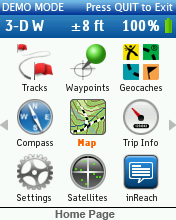
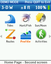
Key Features: |
- Intuitive icon-based user interface for easy on-device
navigation
- Elevation profile cutaway views that pinpoint the user’s
position
- 3.5 GB of user-available Flash memory
- GPX support for improved waypoint, track, and geocache
file management
- No maximum limitations on the quantities of each
that can be saved to internal memory
- In addition, all can be saved to and retrieved
from SD cards
- Tracks can hold 20,000 points; you can edit track
settings to (upon hitting 20,000 points) automatically save
the active track and start another; overwrite the existing
track points (oldest first); or stop track recording
entirely
- Holds 100 routes
- Power Management System optimizes battery performance
- Sleep When Stationary - puts device in "doze mode" if no
movement is detected for 60 seconds
- Stealth Mode - mutes all audible alerts, turns off
backlight
- Button Lock option - prevents unwanted device activation
or data input
|
|
|
|
Powerful GPS Performance Features |
- High-sensitivity 32-channel STMicroelectronics Cartesio
chipset and DeLorme ConstantLock for quick satellite
acquisition and reliable signal retention
- DeLorme predictive GPS calculates satellite positions
for near instantaneous acquisition
- Dual-core processor for near-instananeous map and
imagery screen renderings
- 3-axis electronic compass performs when held
in any position, lets you determine direction while standing
still
- Sensitive barometric altimeter for highly-accurate
reliable altitude readings
- 65K bright-color TFT screen for clarity in any light
conditions
- On-device road routing
- Support for SD cards up to 32 GB
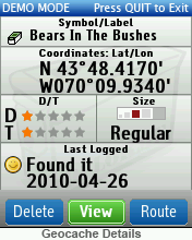
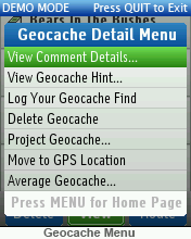
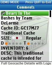
- Support for paperless geocaching
|
|
|
|
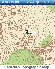
The Most Comprehensive GPS Detail Available |
- On-device data layering lets you see your GPS location
with the advantage of numerous map and imagery choices.
Switch among them to gain a comprehensive view of where you
are - it’s revolutionary and provides a level of geographic
detail unavailable on any other handheld GPS.
- Layer all these map and imagery options on your PN-60
and always have the right detail for any activity, wherever
you go in the world. PN-Series receivers also display
market-leading Navionics lake maps and marine charts (no
set-up required, sold separately on SD cards).
|
|
|
|
Complete Detailed U.S. and Canada Topographic and Street
Maps (included with all PN-Series GPS purchases) |
- Detailed vector-based maps created from the USGS
topographic data and the latest DeLorme U.S. street and
trail network
- U.S. land cover including wetlands, forests, mountains,
glaciers, grasslands, rock cover & more
- Bodies of water, including minor lakes and streams
|
|
|
|
USGS Topographic Maps |
- Authentic U.S. Geological Survey 1:24,000 (7.5-min.)
topo quads, scanned into a seamless database
- See roads, trails, locations of buildings, natural
landmarks, and an endless variety of physical features
- Complete U.S. coverage
|
|
|
|
Canada Topographic Maps |
- Official Natural Resources Canada data
- Topographic contour lines, bodies of water, roads and
trails, also significant buildings, historic sites, and
other manmade features in urban areas.
- 1:50.000 scale
- Coverage for most of Canada
|
|
|
|
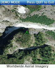
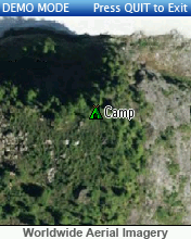
Color Aerial Imagery |
- Two-meter resolution for the entire U.S.
- One-meter resolution for selected cities and surrounding
areas
|
|
|
|
NOAA Nautical Charts |
- The complete set of U.S. waterway charts available,
including coastlines, Great Lakes, Alaska, Hawaii, many
navigable rivers
- Detail includes aids to navigation, water depths, water
body names, hazards, and more
|
|
|
|
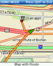
Effortless Track, Waypoint, and Route Management Details |
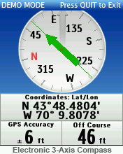
- A green arrow shows your location on the screen map, and
points in your direction of travel. For screen orientation,
you can select north up, course up, or heading up. The
PN-60 will automatically collect a track as you travel. You
can save the collected track, use it to create a route, and
(when you’re back home) convert it to a routable road or
trail within Topo North America.
- Create waypoints with the click of a button, select from
a vast menu of symbol options for the appropriate icon and
add descriptive comments.
- With the PN-60's search
capability, you can locate cities and towns, roads, trails,
natural features, points of interest including businesses,
restaurants, campgrounds, and much more; any search result
can be saved as a waypoint.
- Create road routes or direct point-to-point routes on
the device, or easily import road or trail routes from Topo
North America. When navigating on a route, the PN-60 emits
audible turn alerts (your choice of numerous sounds - ring,
beep, whistle, etc.).
|
|
|
|
Customize the PN-60 to Meet Your Needs |
- You can customize the PN-60's Information Page for your
trip so that everything you want to know is all on one
screen:
- Time or distance to next turn or finish (if navigating
on a route)
- Distance traveled (odometer)
- Trip time
- Speed
- Battery life, GPS accuracy
- Also create custom set-ups for quick access to the PN-60
screens and features you want for your favorite activities
- and much more!
|
|
|
|
New Custom Controls Put You in Charge |
- Button Locking - prevents accidental unit activation or
data input (enabled using the Power button)
- Stealth Mode - enforces sound and light discipline
- Power-Saving Mode - increases battery life 2x, ideal for
use when packing the device for occasional check-ins but not
steady usage
- Low-Level Nighttime Illumination - enhances light
discipline in theater operations
- Project waypoints - "Look ahead" feature for sighting
downrange
|
|
|
|
DeLorme Topo North America 9.0 Details |
|
|
- Comprehensive street and
topographic coverage for the U.S. and Canada
- Land cover
- Lakes and streams
- Updated U.S. trails
- U.S. state and national parks
and forests
- Boat ramps, campgrounds,
hunting and fishing spots, unique natural features
- Over 4 million U.S. and Canada
places of interest
- Gazetteer point data
descriptions from DeLorme Atlas & Gazetteer series (U.S.)
- Mexico main roads
|
Desktop Mapping and GPS Features:
|
- Automatic road and trail routing
- Easy GPX file exchanges with PN-60w (waypoints, tracks,
routes, geocaches)
- Convert imported tracks to routable roads or trails
- Realistic 3-D terrain views with flyovers
- Highly-defined shaded relief
- Contour lines with elevation numbers
- Split screen integration with aerial imagery, USGS and
Canada topos, NOAA nautical charts, and more
- Use draw tools to add waypoints and tracks for upload to
PN-60
- Paperless geocaching, Pocket Query imports
- In-vehicle, run Topo North America 9.0 on laptop PC
connected to PN-60 or other Earthmate GPS for voice-guided
navigation
- Versatile print features - create handy take-along
reference maps for in-vehicle, on the water, or in the
field.
|
|
|
|
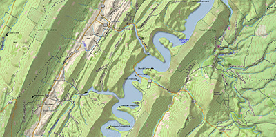
Sample Screens |
|
|
|
|
|
|
|
Specifications |
|
|
|
Part Number |
AE-8188-201 (PN-60), AE-8231-201 (PN-60w),
AE-8242-201 (PN-60 Military Edition) |
|
Unit Dimensions |
2.43" x 5.25" x 1.50" (6.2 cm x 13.3 cm x 3.8 cm) |
|
Display Size |
1.38" x 1.75" (3.5 cm x 4.4 cm), 2.2" (5.6 cm) diagonal |
|
Display Resolution |
176 x 220 |
|
Display Type |
65K
Color Transflective TFT |
|
Weight |
5.35 oz (152 g) without batteries |
|
Battery Type |
AA x 2 or Rechargeable Li-Ion |
|
Battery Life |
29 hours (Lithium AA), 17 hours (Alkaline AA), 13 hours
(1400 mAh Rechargeable Li-ion) |
|
Battery Life (Power Save) |
50 hours (Lithium AA), 30 hours (Alkaline AA), 21 hours
(1400 mAh Rechargeable Li-ion) |
|
Sleep When Stationary Mode |
Yes |
|
Stealth Mode |
Yes |
|
Button Lock |
Yes |
|
Operating Temperature |
-4° F to 167° F (-20° C to 75° C) |
|
Storage Temperature |
-49° F to 212° F (-45° C to 100° C) |
|
Impact Resistance |
MIL STD 810F |
|
Waterproof |
IPX7 |
|
Floats |
No |
|
Interface |
Proprietary 8-pin USB cable |
|
Dual-Core Processor |
Yes |
|
GPS Receiver |
STM Cartesio (32 Channel) with ContantLock satellite retention
and predictive GPS |
|
GPS Antenna |
Patch |
|
GPS Constellations |
GPS +
WAAS |
|
GPS Kalman Filter |
Yes |
|
GPS Position
Accuracy (95%) |
< 15 meters (GPS), < 3 meters (WAAS) |
|
GPS Velocity Accuracy |
0.05 meter / second steady state |
|
GPS Hot Start |
5 - 6 seconds |
|
GPS Warm Start |
< 45 seconds |
|
GPS Cold Start |
< 60 seconds |
|
GPS Update Rate |
1 / second, continuous |
|
Pairs With SPOT / inReach |
Yes (PN-60w) |
|
Two-Way Global SOS |
Yes (PN-60w + inReach) |
|
Two-Way Text Messaging |
Yes (PN-60w + inReach) |
|
Message Size |
160 characters (PN-60w + inReach) |
|
Message Delivery Confirmation |
Yes (PN-60w + inReach) |
|
GPS Tracking and Sharing |
Yes (PN-60w + inReach) |
|
Location Pinging |
Yes (PN-60w + inReach) |
|
Altimeter |
Yes |
|
Barometer |
Yes |
|
Compass |
3D |
|
Accelerometer |
Yes |
|
Routes |
100 |
|
Tracks |
Unlimited (20,000 points per track) |
|
Waypoints /
Geocaches |
Unlimited (1,500 per GPX) |
|
Almanac Information |
Yes (Tides, Sun and Moon, Hunt and Fish) |
|
Point-to-Point Navigation |
Yes |
|
On Road Navigation |
Yes |
|
Trip Info |
Yes |
|
Track Log |
Yes |
|
Internal Memory |
2.85 GB (PN-60, PN-60w) 16 GB (PN-60wSE) |
|
Expandable Memory |
SD card (max 32 GB) |
|
Pre Loaded Base Map |
Yes (detailed highway-level worldwide basemap) |
|
Can
Add Maps |
Yes |
|
|
|
|
|
Documents |
|
|
|
Earthmate PN-60 Quick Start Guide |
|
Earthmate PN-60 User Manual |
|
Earthmate PN-Series Quick Start Guide |
|
Earthmate PN-Series User Manual (update 2.6) |
|
SPOT Satellite Communicator for Earthmate PN-60w User Manual |
|
Earthmate PN-60w with SPOT Satellite Communicator Fact Sheet |
|
Earthmate PN-Series
Features |
|
Compare Earthmate PN-60 vs PN-60w |
|
Compare Earthmate PN-40 vs PN-60 vs PN-60w |
|
|
|
|
|
Media |
|
|
|
24JUN09 - Earthmate PN-Series Now Support Navionics Lake
and Marine Charts |
|
24JUN09 -
Streamlined Geocaching for
Earthmate PN-Series GPS with Cache Register Widget |
|
06JAN10 - Earthmate PN-60w with SPOT Satellite
Communicator |
|
02JUN10 - Earthmate PN-60w Preview at Teva Mountain Games |
|
23JUN10 -
DigitalGlobe to Provide High-Resolution Earth Imagery for
Handheld GPS Devices |
|
03AUG10 -
DeLorme Unveils New GPS Lineup and Topo North America 9.0 |
|
|
|
|
|
Update History |
|
|
|
Check Firmware Version |
|
|
|
3.7
(14NOV18) (PN-60 / PN-60w) |
- Corrects the issue with the PN-60
showing the incorrect date and time.
- Note: This update is provided as a courtesy by Garmin
and should be considered beta firmware. Other than the
directions given below no technical support will be given
for any issues that may occur due to its installation. Given
the beta status of this firmware, it is possible that your
device may be inoperable following installation.
|
|
|
|
3.6
(05DEC13) (PN-60 / PN-60w) |
- SOS countdown counts the correct number of seconds.
- On the Track page, the Track by Distance setting is now
retained.
- Some display issues when composing an inReach message
and receiving one concurrently no longer appear.
- Time for creating a route has been reduced.
- A number of improvements for how the map is displayed
including:
- Increased speed when viewing lines that are labeled.
- Raster maps drawing correctly when the map is rotated
(orientation other than North up).
- Turn arrows on the Directions page should be pointing in
the correct direction now.
|
|
|
|
3.4 (15JUN12) (PN-60
/ PN-60w) |
- inReach - Unread message count is now displayed on the
Map page.
- inReach - Date stamp on reference points sent is
now the message date, not the reference point date.
- inReach - Messages now show time sent, not time
received.
- inReach - History can now be exported.
- inReach - Track and message icons display with the point
of the icon on the location.
- Improvements to default layering for NOAA charts.
- Speeds above 335 MPH are encoded correctly.
- Multiple minor bug fixes.
|
|
|
|
3.3 (14NOV11) (PN-60
/ PN-60w) |
- Updated the Tides page.
- Added Apple OS X Lion Support.
- Corrected possible issue with GPX file import from the
PN-60.
- Added inReach Support.
|
|
|
|
3.1 (14JAN11) (PN-60
/ PN-60w) |
- Corrects an occasional issue where the device would not
properly maintain time after being powered off.
|
|
|
|
|


