|
1. |
With [Setup > Position Format =
hddd°mm.mmm'] selected, coordinates are actually displayed as hddd°mm.mmmm'.
(Please update this menu selection to read hddd°mm.mmmm') (see
Feature Request 7) |
|
[310] [420]
[530] |
|
2. |
[Setup > Units] preferences are
not Profile dependent, like with previous and/or similar Garmin GPSr. [groundspeak] |
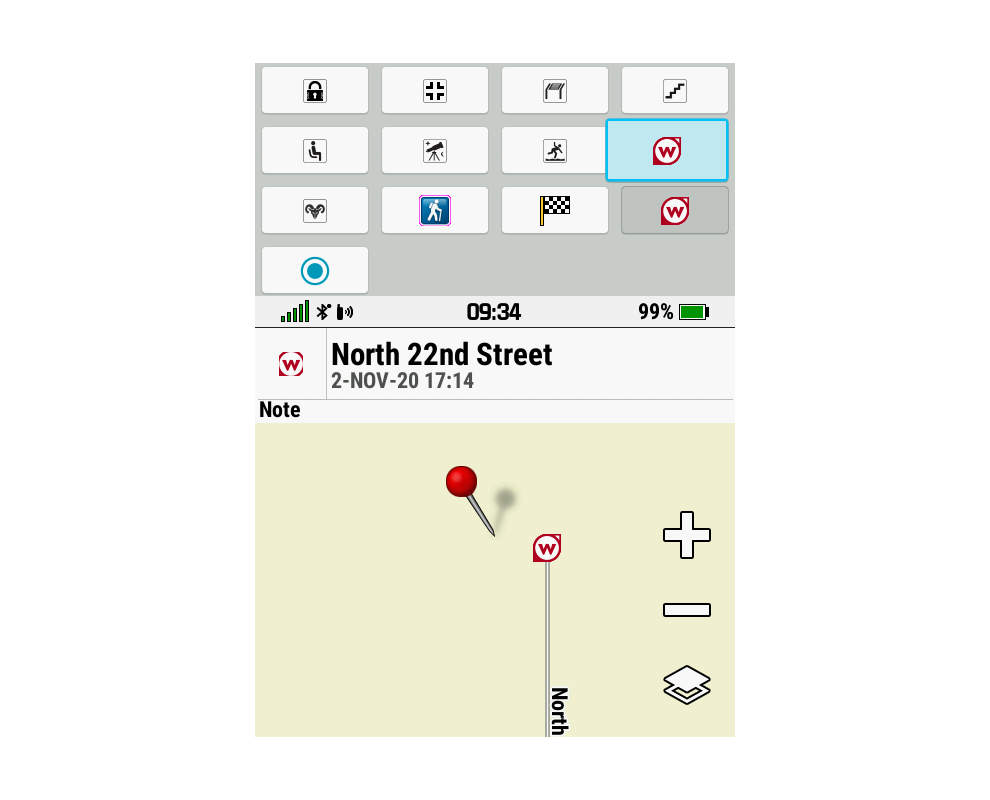
|
[310] [420]
[530] |
|
3. |
Routing method does not change
when switching between profiles where the new profile routing method is
set to 'Prompted' (should be Profile dependent).
[Garmin: "This behavior is by
design"] |
(1834) |
[310]
[420] [530] [640] [710] [820] [840] [850] [920] [1050]
[1080] [1090] [1210] [1310] [1320] [1480] [1500] [1510] [1520]
[1650] [1670] [1810] [1890] [1900] [1910]
[1920] [2030] [2050] [2270] [2310] [2330] [2410] [2420] [2430] [2450]
[2470] [2510] |
|
4. |
POIs with proximity alerts sent
to the Montana 7x0 using Garmin POI Loader 2.7.3 may fail to alert as
expected. [groundspeak] |
(1733) |
[310] [420] [530] [640] [710] [820] [840] [850] [920] [1050] [1080] [1090] [1210] [1310] [1320] [1480] [1500] [1510]
[1520] [1650] [1670] [1810] [1890]
[1900] [1910] [1920] [2030] [2050] [2270] [2310] [2330] [2410] [2420]
[2430] [2450] [2470] [2510] |
|
5. |
The user selected day in the
Calendar, Hunt and Fish, or Sun and Moon pages may 'jump' to the
previous day on devices operated in time zones where daylight
savings time is not observed. (example) |
(1405) |
[310] [420]
[530] |
|
6. |
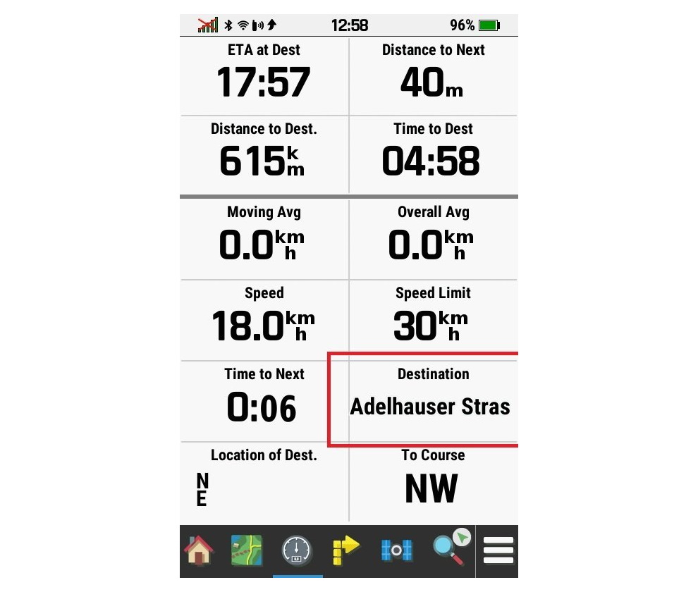
While viewing a Tide Table Chart:
- Selecting [Menu > Hide Chart] results in
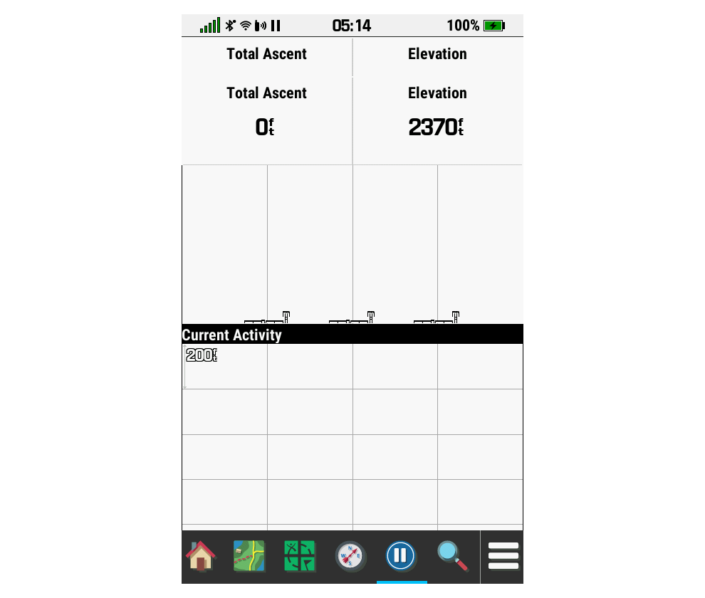
not only the Tide Chart being removed, but most of the alpha-numeric
data in the upper pane is also removed.
- Selecting [Menu > Show Chart] results in
the lower pane graph being displayed again, but this time without
the Tide Plot while the data previously removed from the upper pane
remains MIA.
- Rotating the display 90° restores the missing Tide Plot and data when [Setup > Display > Orientation Lock = Auto], and may
also result in Crash 1.
|
(1739) |
[310]
[410] |
|
7. |
Intermittently, waypoint
distances listed in the Waypoint Manager page may suddenly change from
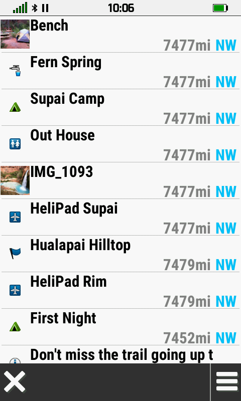
the actual distance to the approximate distance to null island. [example] |
|
[310] |
|
8. |
Adventures may randomly lose data
and/or disappear from the device, and the user may find Adventure data
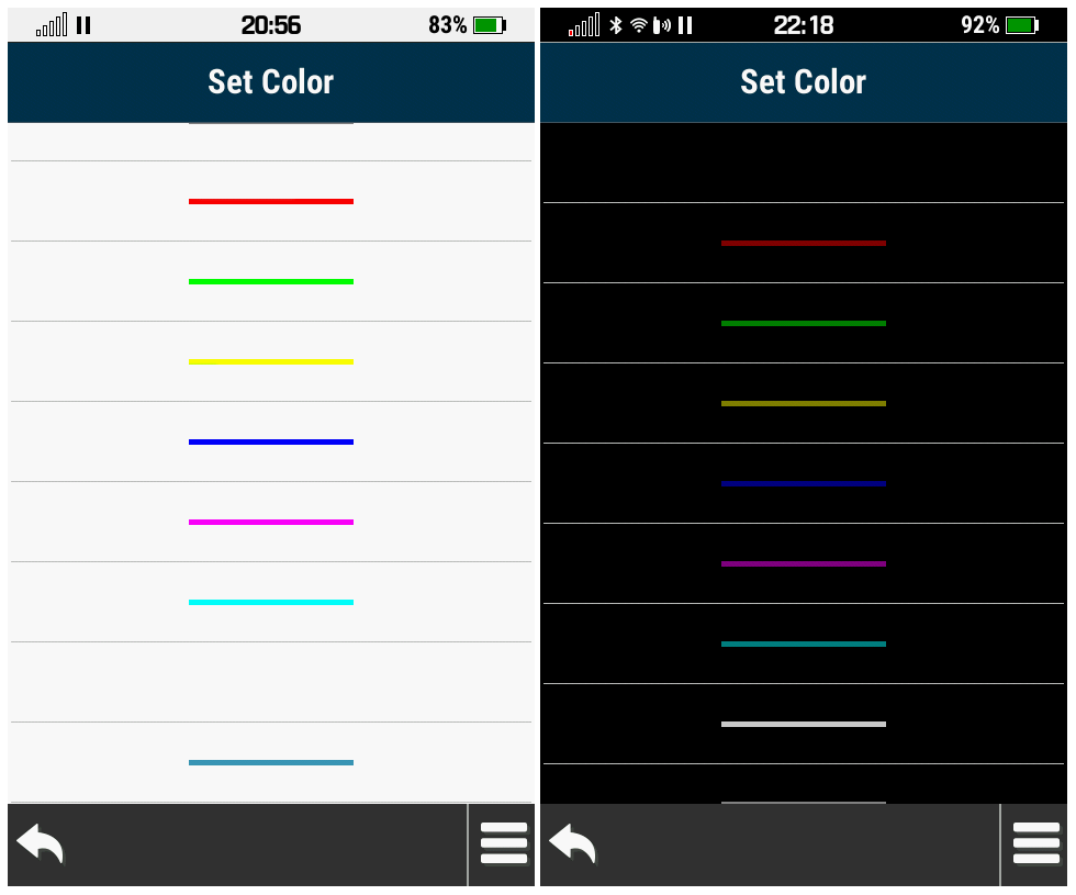
files moved and/or deleted between microSD card and internal memory, all
without any warning or user intervention. |
|
[310] [420] [530] [640] [710] [820] [840] [850]
[920] [1050] [1080] [1090] [1210] [1310] [1320] [1480] [1500]
[1510] [1520] [1650] [1670] [1810]
[1890] [1900] [1910] [1920] [2030] [2050] [2270] [2310] [2330] [2410]
[2420] [2430] [2450] [2470] [2510] |
|
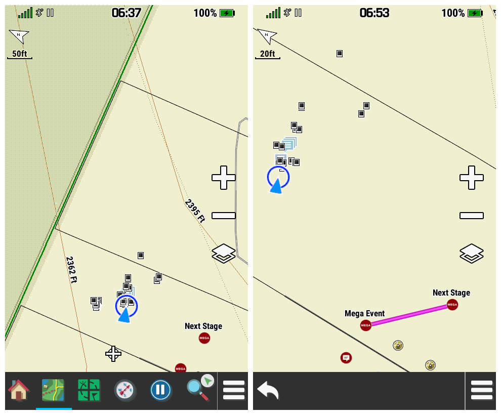
9. |
When navigating to the 'Next Stage'
coordinates for a geocache loaded via GCLive (does not exist in any GPX or GGZ file),
the Geocaching page will no longer display the description for the parent
geocache, which often includes important information required to complete
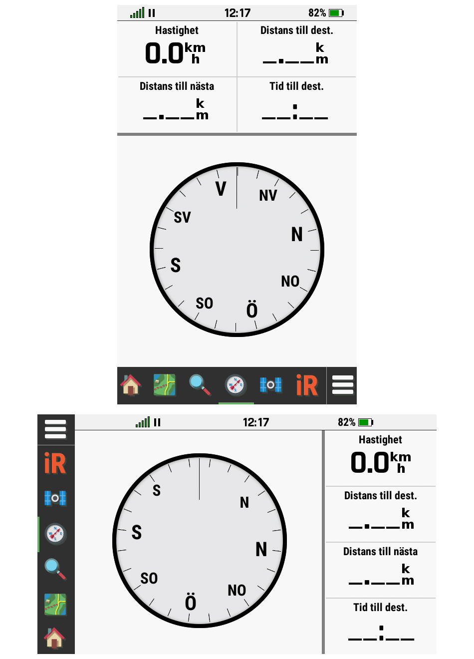
the search. (garmin.de) |
|
[310] [420]
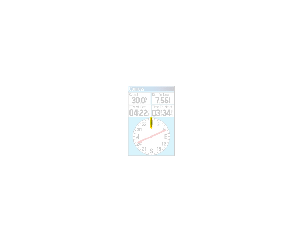
[530] |
|
10. |
GCLive function fails to
download any additional child waypoints (Parking, Multi-cache stages,
etc.) when available, effectively rendering the GCLive 'feature'
useless for a large percentage of available geocaches. [groundspeak] |
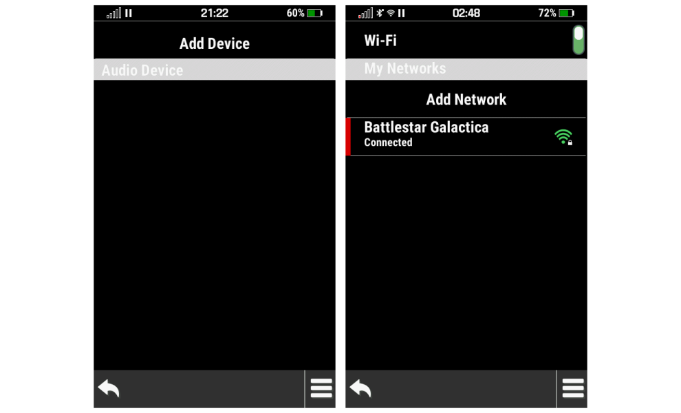
|
[310]
[410] |
|
11. |
Cycling the Power button while
viewing the chirp information page fails to perform the function
configured in [Setup > System > Power Key > Single Tap], and instead
initiates the [Go] function. |
(1340) |
[310]
[410] |
|
12. |
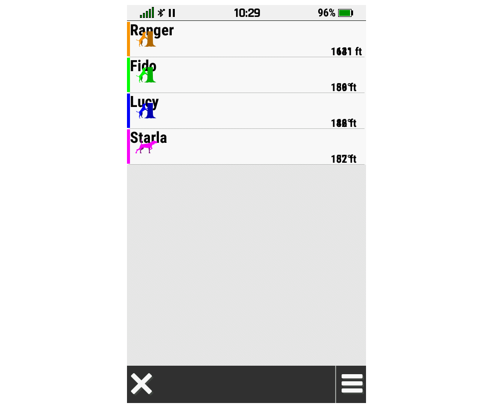
While creating a route in the Route
Planner page, after selecting [Add New Point > Use Map] and selecting [Use]
on the Map page, there is no confirmation to the user that the selected map
point has been added to the current route. |
|
[310]
[420] |
|
13. |
When reviewing a route in Route
Planner, selecting Elevation Plot and then selecting any location along
the displayed elevation plot and selecting [Menu > View Map] results in
the selected location being displayed on the map without the route being
displayed, which is contradictory to previous Garmin GPSr. The selected
route should be displayed here. |
(1662) |
[310]
[410] |
|
14. |
Selecting [Where To? > Routes >
{choose route} > Go] then [Where To? > Change Route Activity > {choose
activity}] can result in the active route no longer being displayed on the map
page. (may be related to
Bug 23) |
|
[310]
[420] |
|
15. |
Opening a saved track and
selecting the 'Track Name', 'Track Color', 'Show on Map' or the
'Favorite Star' does not provide any highlight feedback, which is
inconsistent with previous models. |
(1821) |
[310] [420] [530] [640]
[710] |
|
16. |
Selecting [Waypoint Manager >
{choose waypoint} > Menu > Reposition Here] immediately and irreversibly
changes the selected waypoint coordinates without a confirmation prompt. |
(1651) |
[310]
[410] |
|
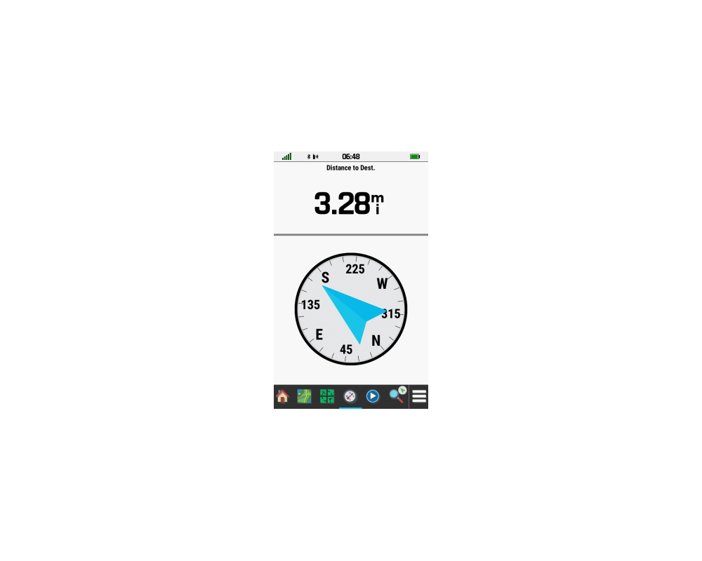
17. |
While the Compass dashboard
is displayed on the Map page,
the user is unable to select
visible map details displayed to either
side of the compass ring. [Garmin: "No
improvements currently scheduled"] |
(1629) |
[310] [420] [530] [640] [710] [820] [840] [850]
[920] [1050] [1080] [1090] [1210] [1310] [1320] [1480] [1500]
[1510] [1520] [1650] [1670] [1810]
[1890] [1900] [1910] [1920] [2030] [2050] [2270] [2310] [2330] [2410]
[2420] [2430] [2450] [2470] [2510] |
|
18. |
Database synchronization between the Montana 7x0 and Explore
app is frequently corrupted, resulting in lost and/or duplicated waypoints, tracks,
activities
and routes in both locations. [more
info] |
|
[310] [420] [530] [640] [710] [820] [840] [850]
[920] [1050] [1080] [1090] [1210] [1310] [1320] [1480] [1500]
[1510] [1520] [1650] [1670] [1810]
[1890] [1900] [1910] [1920] [2030] [2050] [2270] [2310] [2330] [2410]
[2420] [2430] [2450] [2470] [2510] |
|
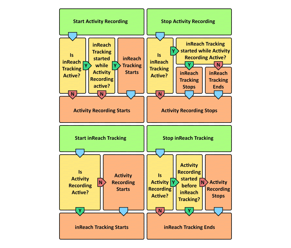
19. |
Complex integration of
inReach
tracking + Activity recording controls that attempt to outsmart the user
can provide unpredictable tracking behaviors that may result in a loss
of user data and/or leave the user stranded without an uploaded
breadcrumb trail directing rescue teams to their location. |
|
[310] [420] [530] [640] [710] [820] [840] [850]
[920] [1050] [1080] [1090] [1210] [1310] [1320] [1480] [1500]
[1510] [1520] [1650] [1670] [1810]
[1890] [1900] [1910] [1920] [2030] [2050] [2270] [2310] [2330] [2410]
[2420] [2430] [2450] [2470] [2510] |
|
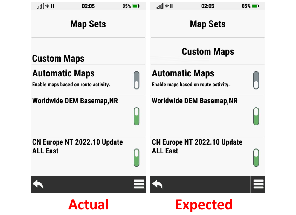
20. |
An inability to differentiate
between individual maps within the same map family (i.e. OSM vs
TopoActive) frequently results in unwanted map layer
configuration changes each time TopoActive or City Navigator maps are
enabled/disabled via 'Automatic Maps' or the Map page map layer
selection menu. |
|
[310] [420] [530] [640] [710] [820] [840] [850]
[920] [1050] [1080] [1090] [1210] [1310] [1320] [1480] [1500]
[1510] [1520] [1650] [1670] [1810]
[1890] [1900] [1910] [1920] [2030] [2050] [2270] [2310] [2330] [2410]
[2420] [2430] [2450] [2470] [2510] |
|
21. |
Using the Map page map layer
selection menu to enable/disable TopoActive or City Navigator maps
frequently results in corruption of the user configured default map selections for
the active profile. |
|
[310] [420] [530] [640] [710] [820] [840] [850]
[920] [1050] [1080] [1090] [1210] [1310] [1320] [1480] [1500]
[1510] [1520] [1650] [1670] [1810]
[1890] [1900] [1910] [1920] [2030] [2050] [2270] [2310] [2330] [2410]
[2420] [2430] [2450] [2470] [2510] |
|
22. |
Geocache title text and geocache
icon overlap each other on geocache dashboard. [example] |
(1744) |
[310]
[410] |
|
23. |
Selecting [Where To? > Routes > {choose route} > Go > Direct Routing]
then [Where To? > Change Route Activity > {Automotive or Motorcycle}]
with only TopoActive maps enabled always results in the device replacing the selected route destination with the most recent previous
user destination. (may be related to
Bug 14) |
(1865) |
[310] [420]
[530] |
|
24. |
Successful 'Mode' configuration
changes executed for a VIRB camera connected via VIRB Remote are not
reflected or updated in the Montana 7x0 VIRB setup menus. |
(1601) |
[310] [420] [530] [640] [700] |
|
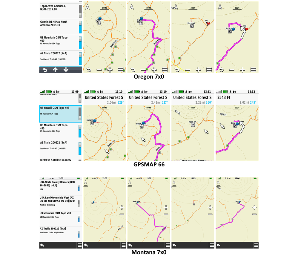
25. |
The Montana 7x0 frequently
ignores embedded routing information available with many popular third
party maps that are properly recognized by previously released models
(Montana 6x0, Oregon 6x0/7x0, Rino 7x0, GPSMAP 66, etc.). [example] |
(1104) |
[310] [420] [530] [640] [710] [820] [840] [850]
[920] [1050] [1080] [1090] [1210] [1310] [1320] [1480] [1500]
[1510] [1520] [1650] [1670] [1810]
[1890] [1900] [1910] [1920] [2030] [2050] [2270] [2310] [2330] [2410]
[2420] [2430] [2450] [2470] [2510] |
|
26. |
Device is unable to connect to Wi-Fi networks with
hidden SSID. |
(1971) |
[310] [420]
[530] [640]
[710] [800] |
|
27. |
Garmin Adventure Photos loaded to
the microSD card are not properly indexed or displayed when sorted by 'Most
Recent' in 'Photo Viewer' page, but are properly displayed when viewed from
Adventure Content page. |
(1826) |
[310] [420] [530] [640] [710] [820]
[830] |
|
28. |
Geocaches loaded via 'Share
Wirelessly' do not include necessary child waypoints when present. |
|
[420] [530] [640] [710] [840] [850] [920] [1050]
[1080] [1090] [1210] [1310] [1320] [1480] [1500] [1510] [1520]
[1650] [1670] [1810] [1890] [1900] [1910]
[1920] [2030] [2050] [2270] [2310] [2330] [2410] [2420] [2430] [2450]
[2470] [2510] |
|
29. |
Custom Geocache Symbols loaded
to the device may be displayed 'cropped' in
the Geocache page List tab. [Gr] |
|
[310] [420] [530] [640]
[710] |
| 30. |
Starting the Montana 7x0 with
geocache proximity alerts enabled while several hundred
geocaches are loaded via GGZ files frequently results in a substantially
longer boot sequence duration. |
(1998) |
[630] |
| 31. |
Geocaches logged as found on the Montana 7x0 and listed as found in
Calendar page are sometimes displayed as not found on the Map page. |
(1557) |
[310] [420] [530] [640] [710] [820] [840] [850] [920] [1050] [1080] [1090] [1210] [1310]
[1320] [1480] [1500] [1510] [1520]
[1650] [1670] [1810] [1890] [1900] [1910]
[1920] [2030] [2050] [2270] [2310] [2330] [2410] [2420] [2430] [2450]
[2470] [2510] |
| 32. |
Geocache 'Child Waypoints' are
always displayed by 'Code', and never by 'Name', regardless of [Setup > Geocaching
> Geocache Style] configuration. |
|
[420] [530]
[640] [710] [820]
[840] [850] [920] [1050] [1080] [1090] [1210] [1310] [1320]
[1480] [1500] [1510] [1520]
[1650] [1670] [1810] [1890] [1900] [1910] [1920] [2030] [2050] [2270]
[2310] [2330] [2410] [2420] [2430] [2450] [2470] [2510] |
| 33. |
After
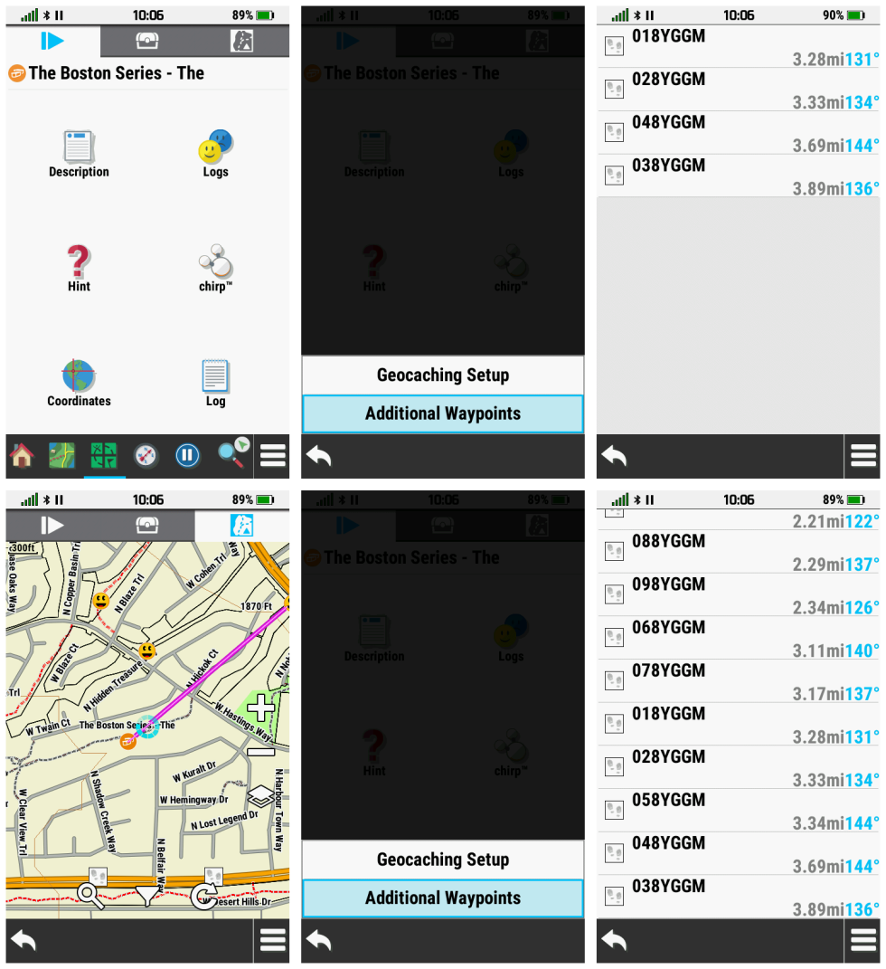
beginning navigation to a geocache child waypoint,
having just selecting the child waypoint from
the Geocache page 'Additional Waypoints' menu,
the user no longer has access to the parent geocache information from
the Geocaching page. Child Waypoints (or 'Additional Waypoints') should
always be treated as 'Via Points' when selected from the 'Additional
Waypoints' menu.
[choose 'Add as Via Point',
not 'Set as New Destination' to resolve issue] |
|
[640]
[710] |
| 34. |
Custom Waypoint Symbols loaded to the device may be displayed
'cropped' in the Waypoint Edit page. [example] |
|
[310] [420] [530] [640]
[710] |
| 35. |
Custom Waypoint Symbols loaded to the device with names including a 'Hot
Spot' are ignored and not displayed. |
(2034) |
[310] [420] [530] [640] [710] [820] [830] |
|
36. |
While programming a chirp device, after choosing a
waypoint or a geocache, the map page is frequently displayed with the
'Go' button instead of the 'Send' button. |
|
[640] [710] [820] [830] |
| 37. |
When opening the Geocache page while navigating to a
geocache child waypoint selected from the 'Additional Waypoints' menu,
the 'Geocache List' tab is displayed instead of the 'Active Geocache'
tab, which is the expected and customary behavior while navigating to a
geocache.
|
|
[710] [800] |
| 38. |
Garmin maps purchased via direct download or microSD may not be
recognized or properly displayed on the Montana 7x0. [garmin]
[garmin]
[garmin] |
|
[310] [420] [530] [640] [710] [820] [840] [850]
[920] [1050] [1080] [1090] [1210] [1310] [1320] [1480] [1500]
[1510] [1520] [1650] [1670] [1810] [1890] [1900] [1910] [1920]
[2030] [2050] [2270] [2310] [2330] [2410] [2420] [2430] [2450] [2470] [2510] |
| 39. |
Course (CDI) bearing line remains positioned
over the course line during off-course navigation. This behavior
is inconsistent with many prior and current generation Garmin GPSr. [garmin.de]
[garmin.de] |
|
[310] [420] [530] [640] [710] [820] [840] [850]
[910] |
| 40. |
Geocaches listed in the Adventure Content Menu
may not appear when selected. |
|
[310] [420] [530] [640] [710] [820] [840] [850]
[920] [1050] [1080] [1090] [1210] [1310] [1320] [1480] [1500]
[1510] [1520] [1650] [1670] [1810] [1890] [1900] [1910] [1920]
[2030] [2050] [2270] [2310] [2330] [2410] [2420] [2430] [2450] [2470] [2510] |
| 41. |
The first boot sequence after any geocache GPX/GGZ files are updated
frequently requires an hour or more to complete unless the user also
deletes the [GPSr:]\Garmin\EDM\ directory before restarting the unit. [Gr] |
|
[530] [640]
[710] [820] [840] [850] [920] [1050]
[1080] [1090] [1210] [1310] [1320] [1480] [1500] [1510] [1520]
[1650] [1670] [1810] [1890] [1900] [1910] [1920] [2030] [2050] [2270]
[2310] [2330] [2410] [2420] [2430] [2450] [2470] [2510] |
| 42. |
The Montana 7x0 consistently locates fewer Galileo satellites than
comparable Garmin devices when used side by side. |
|
[310] [420] [530] [640] [710] [820] [840] [850]
[920] [1050] [1080] [1090] [1210] [1310] [1320] [1480] [1500]
[1510] [1520] [1650] [1670] [1810] [1890] [1900] [1910] [1920]
[2030] [2050] [2270] [2310] [2330] [2410] [2420] [2430] [2450] [2470] [2510] |
|
43. |
The Montana 7x0 Active Route page can be very
slow to respond while navigating longer routes, especially when compared
to a GPSMAP 276Cx with the same route loaded. [Gr] |
|
[710] [820] [840]
[850] [920] [1050]
[1080] |
|
44. |
The Active Route page list display alignment can
result in overlapping text. [example]
[Gr] |
|
[710] [820]
[830] |
|
45. |
Configuring [Setup > Waypoints > Suffix = 0000] results in a value of
'10000' being displayed in the setup menu, and the next marked waypoint
will use the first available suffix counting up from '0000'. [Gr] |
|
[710] [820] [840]
[850] [910] |
| 46. |
Imported routes can not be
started while GPS Demo Mode is enabled. This behavior is inconsistent
with many current and previous Garmin models. [Gr]
[Garmin: "This issue will not be corrected. The Montana will simulate to
a point, but we do not have an option to simulate an entire route."] |
|
[710] [820] [840] [850] [920] [1050] [1080] [1090] [1210]
[1310] [1320] [1480] [1500] [1510] [1520]
[1650] [1670] [1810] [1890] [1900] [1910]
[1920] [2030] [2050] [2270] [2310] [2330] [2410] [2420] [2430] [2450]
[2470] [2510] |
| 47. |
Selecting 'Refresh Geocaches' from the Geocache page Map
tab frequently
results in geocaches being loaded for a nearby map location that was not
previsouly displayed or in focus. |
|
[820]
[830] |
| 48. |
Panning and zooming on the Map page frequently results in the display
jumping to a nearby location not previously displayed or in focus. |
|
[820]
[830] |
| 49. |
Selecting [Menu > Show Waypoints] in the Geocache page Map tab always
fails when [Setup > Map > Advanced Setup > Zoom Levels > User Waypoints
= {anything other than Auto}]. |
(2119) |
[820] [830] |
| 50. |
Altimeter page data fields are duplicated when selected while no
elevation data is present. [example]
[Gr] |
|
[710] [820] [830] |
| 51. |
The Destination data field text alignment can
result in an overlapping display. [example]
[Gr] |
|
[710] [820] [840] [850]
[910] |
| 52. |
All auto-archived tracks are saved with the 'Auto' suffix regardless of
user selection in [Setup > Recording > Advanced Setup > Auto Save], a
behavior inconsistent with current and previous Garmin Outdoor
Recreational Handheld devices. |
|
[820]
[840] [850] [920] [1050]
[1080] [1090] [1210] [1310] [1320] [1480] [1500] [1510] [1520]
[1650] [1670] [1810] [1890] [1900] [1910] [1920] [2030] [2050] [2270]
[2310] [2330] [2410] [2420] [2430] [2450] [2470] [2510] |
| 53. |
With Trip Recording configured for 'During
Activity' and Activity Recording paused or inactive, the Recording
Controls Activity Plot Tab accumulates 'Total Ascent' data while the
Information Tab continues to display no change for the same value. |
|
[820]
[840] [850]
[910] |
| 54. |
Map page refresh rate is insufficient at lower speeds, especially when
compared to similar Garmin products. [video]
[Gr] |
|
[710] [820] [840]
[850] [920] [1050] |
| 55. |
The Automatic
Screen Lock feature does not function properly when
Battery Save mode is
enabled and/or the backlight is adjusted to 00% brightness. [Gr] |
(2219) |
[820] [840] [850] [920] [1050] |
| 56. |
POI files loaded to the 'Garmin/POI/' directory may fail to appear in
the 'Where To?' menu on the Montana 7x0, while the same *.gpi file is
properly indexed when loaded to similar Garmin devices. [Gr] |
|
[820] [840] [850]
[910] |
| 57. |
Weather data may be displayed with improper alignment on Status Page
when viewed in Landscape mode. [Gr] |
|
[820] [840] [850]
[910] |
| 58. |
Route distance displayed in Info Box changes after scrolling the map. [Gr] |
|
[820] [840] [850]
[910] |
| 59. |
GPS Elevation text may be displayed partially off screen on Satellite
page. [Gr] |
|
[820] [840] [850]
[910] |
| 60. |
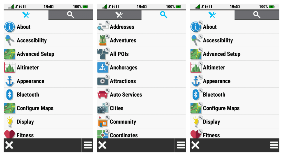
With all available 'Application' icons added to the Main Menu, selecting
"+" to add additional items results in the 'Setup' icons being displayed
without their 'wrench' graphic. Selecting the 'Search' tab (all icons
will have magnifying glass graphic) and then the 'Setup' tab again
restores the proper Setup Menu icons. [example] [Gr] |
|
[710] [820] [840] [850] [920] [1050]
[1080] [1090] [1210] [1310] [1320] [1480] [1500] [1510] [1520] [1650]
[1670] [1810] [1890] [1900] [1910] [1920] [2030] [2050] [2270] [2310]
[2330] [2410] [2420] [2430] [2450] [2470] [2510] |
| 61. |
Geocaches downloaded via GCLive are frequently displayed with incomplete
data, requiring the user to 'refresh' geocache information from the
Geocache page Map Tab multiple times before all data is loaded properly,
which is not a workable option for users that pre-load their geocache
data due to lack of internet service near their destinations. [example] |
|
[420] [530] [640] [710] [820] [840] [850] [920]
[1050] [1080] [1090] [1210] [1310] [1320] [1480] [1500] [1510] [1520]
[1650] [1670] [1810] [1890] [1900] [1910] [1920] [2030] [2050]
[2270] [2310] [2330] [2410] [2420] [2430] [2450] [2470] [2510] |
| 62. |
Map page waypoint name text does not honor display mode changes. User
must disable then enable text display in Map Setup to force correct text
display for current display mode. See
[Gr] post for details. |
|
[820] [840] [850]
[910] |
| 63. |
Keyboard language selection is not retained
across power cycles. |
|
[820] [840] [850]
[910] |
| 64. |
Changing the Route Activity while navigating any route
with Via Points results in all Via Points being stripped from the route.
[Gr] |
|
[820] [840] [850]
[910] |
| 65. |
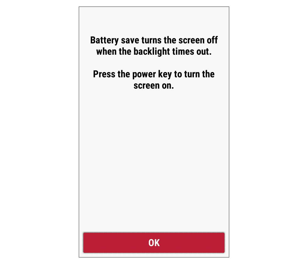
Touching the screen exits Battery Save mode, which is contradictory to
the message displayed when enabled. [example] |
|
[920]
[1050] |
| 66. |
After adding Via Points to an existing route, the first leg of the
route may not be displayed on the map page. [example] |
|
[920] [1050] [1080]
[1090] [1210] [1310] [1320] [1480] [1500] [1510] [1520] [1650]
[1670] [1810] [1890] [1900] [1910] [1920] [2030] [2050] [2270] [2310]
[2330] [2410] [2420] [2430] [2450] [2470] [2510] |
| 67. |
When [Setup > Units > Pressure = Hectopascals], displayed pressure
values are correct while the abbreviation is not. Hectopscals should be
abbreviated 'hPa', not 'Pa'. [Gr] |
(2197) |
[850]
[920] [1050] |
| 68. |
Configuring [Setup > Units > Pressure] for
'Inches (Hg)' or 'Millimeters (Hg)' always results in the pressure
abbreviation 'hg' being displayed. This abbreviation should read either
'inHg' or 'mmHg'. |
|
[850] [920] [1050]
[1080] [1090] [1210] [1310] [1320] [1480] [1500] [1510] [1520]
[1650] [1670] [1810] [1890] [1900] [1910] [1920] [2030] [2050] [2270]
[2310] [2330] [2410] [2420] [2430] [2450] [2470] [2510] |
| 69. |
Route name displayed in Map Page Info Box changes after scrolling the
map. [Gr] |
|
[920]
[1050] |
| 70. |
While viewing waypoints listed in any Adventure Content menu; [Gr]
(A). Selecting [Menu > Sort > {Nearest} or {Alphabetical}] always results in a list of all waypoints loaded on the device being displayed (should only display waypoints associated with the selected Adventure).
(B). Exiting this sorted waypoint list always results in the user being returned to the device Main Menu (should return user to the content menu for the selected Adventure).
|
|
[920] [1050] [1080] [1090]
[1210] [1310] [1320] [1480] [1500] [1510] [1520] [1650] [1670]
[1810] [1890] [1900] [1910] [1920] [2030] [2050] [2270] [2310] [2330]
[2410] [2420] [2430] [2450] [2470] [2510] |
| 71. |
The Blue Pin previously displayed over each waypoint symbol
included as part of an active route is no longer displayed, and has been
replaced by a small difficult to see square icon. [Gr]
[Related:
Requested Feature 50]
[Garmin: "This is an intentional design change to maintain consistent
behavior with similar products"] |
|
[920]
[1050] [1080] [1090] [1210] [1310] [1320]
[1480] [1500] [1510] [1520]
[1650] [1670] [1810] [1890] [1900] [1910] [1920] [2030] [2050] [2270]
[2310] [2330] [2410] [2420] [2430] [2450] [2470] [2510] |
| 72. |
Configuring any activity or track color to Yellow (Recording Controls,
Saved Tracks, Recorded Activities) always results in the selected track
being displayed in Red. [Gr] |
|
[920]
[1050] |
| 73. |
Track colors specified in tracks sent from BaseCamp are not honored. [Gr] |
|
[920]
[1050] |
| 74. |
Choosing [Select Next Point > Addresses > Search Area > Enter City]
always returns the user to the 'Edit Route' page when editing a
previsouly saved route. [Gr] |
|
[920]
[1050] |
| 75. |
[Where To? > Addresses > Search Area] displays '_
_ _ _ _ _ _ _ _ _ _ _ _ _ _ _ _ _' after: [Gr]
- Select [Where To?]
- Choose [Addresses]
- Select [Search Area]
- Select [Enter State/Province]
- Enter 'Arizona' (or any valid option for region)
- Select [Arizona]
- Select again [Search Area]
- Select [Enter City]
- Touch [X] without making an entry
- Select [Back Arrow]
- 'Search Area' now displays '_ _ _ _ _ _ _ _ _ _ _ _ _ _ _ _ _ _'
|
[2261] |
[920]
[1050] [1080] [1090] [1210] [1310] [1320]
[1480] [1500] [1510] [1520]
[1650] [1670] [1810] [1890] [1900] [1910] [1920] [2030] [2050] [2270]
[2310] [2330] [2410] [2420] [2430] [2450] [2470] [2510] |
| 76. |
While configuring a Course, Track or Activity color, the White and Black color
selections blend with the background while the display is in Day or
Night mode, respectively, unlike similar models that use a contrasting outline.
[example]
[example] [Gr] |
|
[920] [1050] [1080] [1090]
[1210] [1310] |
| 77. |
Adding a single Via Point after selecting [Where To? > {any destination}
> Go > {any method}]
always results in a
warning message "Only 50 points can be used for On Road navigation"
being displayed. [example] [Gr] |
|
[920]
[1050] [1080] |
| 78. |
After choosing a destination and selecting 'Go', the provided routing
directions and Active Route page may skip one or more events clearly
displayed by the magenta routing line on the Map page. [Gr]
[Related: Bug 92,
Bug 116,
Bug 117] |
|
[920] [1050] [1080] [1090]
[1210] [1310] [1320] [1480] [1500] [1510] [1520] [1650] [1670]
[1810] [1890] [1900] [1910] [1920] [2030] [2050] [2270] [2310] [2330]
[2410] [2420] [2430] [2450] [2470] [2510] |
| 79. |
Map selection page highlight color is pixelated. [example] [Gr] |
|
[920] [1050] [1080] [1090] [1210] [1310] |
| 80. |
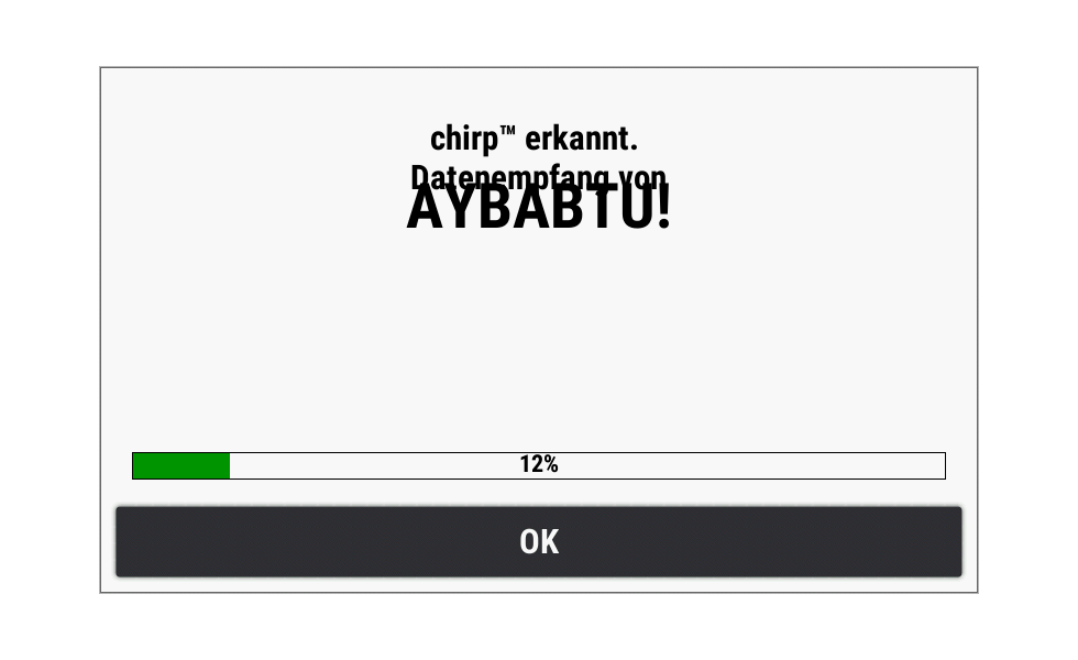
Chirp titles overlap each other when viewed in landscape mode. [example] [Gr] |
|
[920] [1050] [1080] [1090] [1210] [1310]
[1320] [1480] [1500] [1510] [1520] [1650] [1670] [1810] [1890] [1900]
[1910] [1920] [2030] [2050] [2270] [2310] [2330] [2410] [2420] [2430]
[2450] [2470] [2510] |
| 81. |
Selecting 'Menu > Sort > Longest Distance' or 'Menu > Sort > Shortest
Distance' in the Course Planner page does not always result in the
listed courses being sorted as expected. |
|
[1050] [1080] [1090] [1210] [1310] [1320] [1480] [1500] [1510] [1520]
[1650] [1670] [1810] [1890] [1900] [1910] [1920] [2030] [2050] [2270]
[2310] [2330] [2410] [2420] [2430] [2450] [2470] [2510] |
| 82. |
The Course Planner Elevation Plot frequently displays the incorrect
profile for the selected course and navigation method. |
|
[1050] [1080] [1090] [1210] [1310] [1320] [1480] [1500] [1510] [1520]
[1650] [1670] [1810] [1890] [1900] [1910] [1920] [2030] [2050] [2270]
[2310] [2330] [2410] [2420] [2430] [2450] [2470] [2510] |
| 83. |
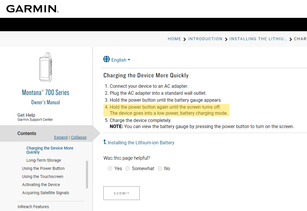
Attempting to enter the low power battery charging mode
as described in the Garmin Montana 7x0 user manual
results in the
device powering off completely.
[Garmin: "This is the desired behavior, manual is not very clear"] |
|
[1050] |
| 84. |
[Setup > Routing > Activity] configuration is not respected when
selecting [Where To? > {any course} > Roads & Trails > Go]. |
|
[1050] [1080] [1090] [1210] [1310] [1320] [1480]
[1500] [1510] [1520] [1650] [1670] [1810] [1890] [1900] [1910]
[1920] [2030] [2050] [2270] [2310] [2330] [2410] [2420] [2430] [2450]
[2470] [2510] |
| 85. |
When resuming from Expedition Mode, the user
configured GNSS settings are not remembered or restored. |
|
[420] [530] [640] [710] [820] [840] [850] [920]
[1050] [1080] [1090] [1210] [1310] [1320] [1480] [1500] [1510] [1520]
[1650] [1670] [1810] [1890] [1900] [1910] [1920] [2030] [2050]
[2270] [2310] [2330] [2410] [2420] [2430] [2450] [2470] [2510] |
| 86. |
Selecting any item on the
Status Page
and
then selecting back will return the user to the status page, except for
'Activity Recording',
which returns the user to the first shortcut in the
Favorites Menu.
[Gr]
[Garmin: "No further corrections will be made
for this behavior."] |
|
[1050] [1080] [1090] [1210] [1310] [1320]
[1480] [1500] [1510] [1520] [1650] [1670] [1810] [1890] [1900] [1910]
[1920] [2030] [2050] [2270] [2310] [2330] [2410] [2420] [2430] [2450]
[2470] [2510] |
| 87. |
The Map page 'Corner
Data Fields' are not profile dependent, which is contrary to all
other Map page data fields. [Gr] |
|
[640] [710] [820] [840] [850] [920] [1050] [1080] [1090] [1210]
[1310] |
| 88. |
Expedition Mode may fail to save track points for all or portions of an
active tracklog recording. |
|
[1080] [1090] [1210] [1310]
[1320] [1480] [1500] [1510] [1520] [1650] [1670] [1810] [1890]
[1900] [1910] [1920] [2030] [2050] [2270] [2310] [2330] [2410] [2420]
[2430] [2450] [2470] [2510] |
| 89. |
When toggling an 'Archived' track to 'Favorite' status, the 'Show on
Map' and 'Color' options fail to appear until after the user exits and
reloads the track again, while toggling a 'Favorite' track to 'Archived'
status and back again correctly hides and shows these options with each
track status change. |
|
[1080] [1090] [1210] [1310]
[1320] [1480] [1500] [1510] [1520] [1650] [1670] [1810] [1890]
[1900] [1910] [1920] [2030] [2050] [2270] [2310] [2330] [2410] [2420]
[2430] [2450] [2470] [2510] |
| 90. |
The compass may fail to display some cardinal letters in landscape mode
when using Swedish language. [example]
[Gr] |
|
[1080] [1090] [1210]
[1310] |
| 91. |
Some map names are truncated and displayed incomplete in the Map page
configuration menu. [example]
[Gr] |
|
[1080] [1090] [1210] [1310]
[1320] [1480] [1500] [1510] [1520] [1650] [1670] [1810] [1890]
[1900] [1910] [1920] [2030] [2050] [2270] [2310] [2330] [2410] [2420]
[2430] [2450] [2470] [2510] |
| 92. |
The magenta routing line displayed on the map page may intermittently
appear to be broken or disjointed, and missing sections commonly
reappear after performing a route recalculation. [example]
[Gr]
[Related: Bug 78,
Bug 116,
Bug 117]
[improved with update v13.10 - but
not fully resolved] |
|
[1080] [1090] [1210] [1310]
[1320] [1480] [1500] [1510]
[1520] [1650] [1670] [1810] [1890] [1900] [1910] [1920] [2030]
[2050] [2270] [2310] [2330] [2410] [2420] [2430] [2450] [2470] [2510] |
| 93. |
'ETA at Destination' and 'Time to Destination' data fields may fail to
populate when using Direct Routing. [Video]
[Gr] |
|
[1080] [1090] [1210] [1310]
[1320] [1480] [1500] [1510] [1520] [1650] [1670] [1810] [1890]
[1900] [1910] [1920] [2030] [2050] [2270] [2310] [2330] [2410] [2420]
[2430] [2450] [2470] [2510] |
| 94. |
While navigating using the Motorcycle activity, the
'ETA at Destination' and 'Time to Destination' data fields may display
inaccurate routing times that are nearly twice the value displayed when
using any other activity. [Gr]
[garmin] |
|
[1080] [1090] [1210] [1310]
[1320] [1480] [1500] [1510] [1520] [1650] [1670] [1810] [1890]
[1900] [1910] [1920] [2030] [2050] [2270] [2310] [2330] [2410] [2420]
[2430] [2450] [2470] [2510] |
| 95. |
The 'Distance to Next' data field may continue counting down even after
the device stops moving. [Video
1] [Video
2] [Gr] |
|
[1080] [1090] [1210]
[1310] |
| 96. |
Recently added 'On Track' and 'Off Track' notifications provide no
options to disable or configure alert sensitivity. [Gr]
[garmin] |
|
[1080] [1090] [1210] [1310]
[1320] [1480] [1500] [1510] [1520]
[1650]
|
| 97. |
Downloading geocache PQ's and Lists via GCLive (Bluetooth and/or Wi-Fi)
frequently fails to complete, and may render the device unresponsive to
user input. |
|
[1080] [1090] [1210] [1310]
[1320] [1480] [1500] [1510] [1520] [1650] [1670] [1810] [1890]
[1900] [1910] [1920] [2030] [2050] [2270] [2310] [2330] [2410] [2420]
[2430] [2450] [2470] [2510] |
| 98. |
Geocaching 'Next Stage' feature fails for geocaches with more than one
'Next Stage'. [Gr] |
|
[1080] [1090] [1210]
[1310] |
| 99. |
The 'Custom Maps' title in the Map page configuration menu is
bottom-left justified, while similar selections (without toggles) are
middle-center justified. [example]
[Gr] |
|
[310] [420] [530] [640] [710] [820] [840] [850]
[920] [1050] [1080] [1090] [1210] [1310] |
| 100. |
The Wi-Fi setup page may fail to display any/all available wireless
networks when a WPA3 network is present. [Gr] |
|
[1090] [1210]
[1310] |
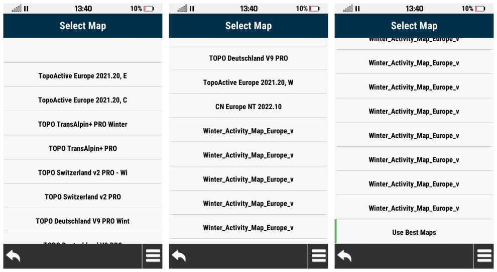
| 101. |
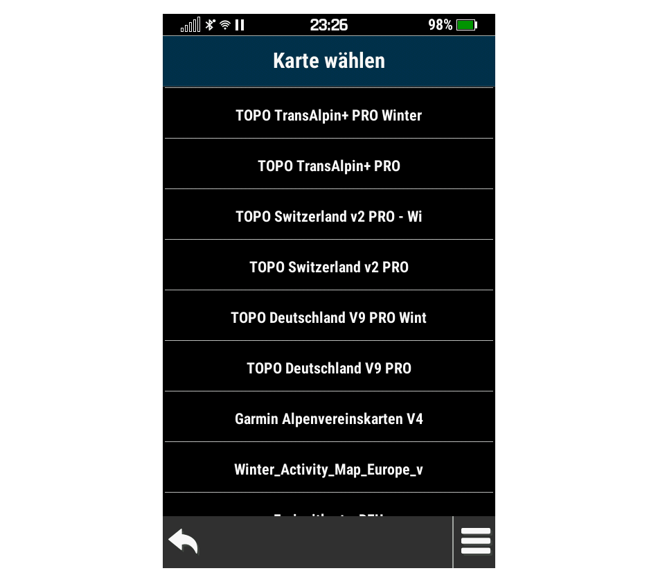
The 'Select Map' menu may display available maps incorrectly and/or in
duplicate. [example]
[Gr] |
|
[1080] [1090] [1210] [1310] [1320]
[1480] [1500] [1510] [1520] [1650] [1670] [1810] [1890] [1900]
[1910] [1920] [2030] [2050] [2270] [2310] [2330] [2410] [2420] [2430]
[2450] [2470] [2510] |
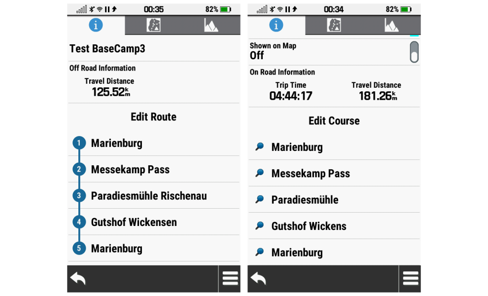
| 102. |
Waypoint names are truncated to 15 characters when converting a route to
a course. [example]
[Gr] |
|
[1080] [1090] [1210] [1310] [1320]
[1480] [1500] [1510] [1520] [1650] [1670] [1810] [1890] [1900]
[1910] [1920] [2030] [2050] [2270] [2310] [2330] [2410] [2420] [2430]
[2450] [2470] [2510] |
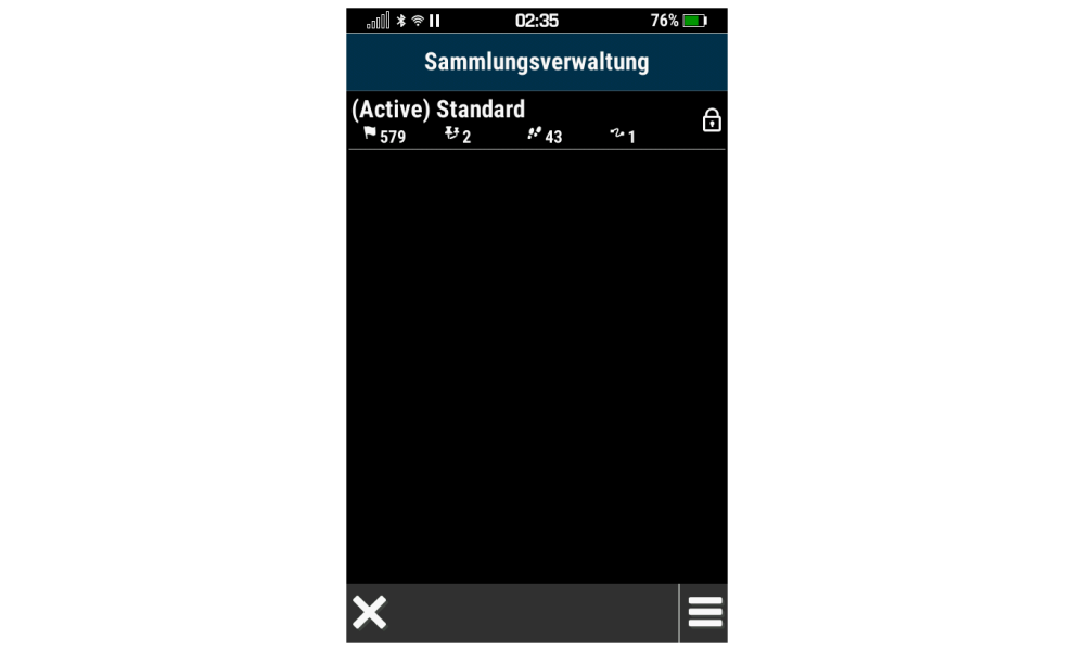
| 103. |
Collections Manager does not translate 'Active' when configured for
German language. [example]
[Gr] |
|
[1050] [1080] [1090] [1210] [1310]
[1320] [1480] |
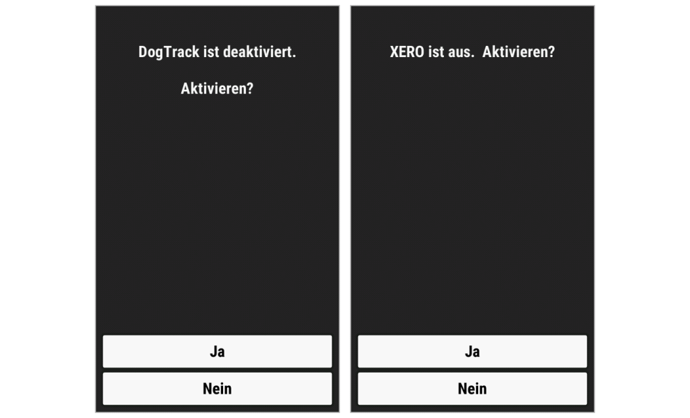
| 104. |
German translation text for 'disabled' is applied inconsistently between
DogTrack and Xero. [example]
[Gr] |
|
[1050] [1080] [1090] [1210] [1310]
[1320] [1480] |
| 105. |
No German translation is provided when
displaying time in seconds ('sekunde' = 's' or 'sek'). [example]
[Gr]
[Garmin: "There will be no further
software adjustments for this issue."] |
|
[1050] [1080]
[1090] [1210] [1310] [1320] [1480] [1500]
[1510] [1520] [1650] [1670]
[1810] [1890] [1900] [1910] [1920] [2030] [2050] [2270] [2310] [2330]
[2410] [2420] [2430] [2450] [2470] [2510] |
| 106. |
Night Mode menu headers are difficult to read
with white text on grey background. [example]
[Gr] |
|
[1050] [1080] [1090] [1210] [1310]
[1320] [1480] [1500] [1510] [1520] [1650] [1670] [1810] [1890]
[1900] [1910] [1920] [2030] [2050] [2270] [2310] [2330] [2410] [2420]
[2430] [2450] [2470] [2510] |
| 107. |
The battery level icons in the status bar, small data field and large
data field do not agree when using AA batteries, regardless of battery
chemistry selection in [Setup > System > Battery Type]. [example] |
|
[310] [420] [530] [640] [710] [820] [840] [850]
[920] [1050] [1080] [1090] [1210] [1310] [1320] [1480] [1500]
[1510] [1520] [1650] [1670] [1810] [1890] [1900] [1910] [1920]
[2030] [2050] [2270] [2310] [2330] [2410] [2420] [2430] [2450] [2470] [2510] |
| 108. |
The External AC Power icons displayed in the large and small data
fields, clearly borrowed from devices with lower resolution screens,
have not been rescaled for the larger Montana 7x0 display. [example] |
|
[310] [420] [530] [640] [710] [820] [840] [850]
[920] [1050] [1080] [1090] [1210] [1310] [1320] [1480] [1500]
[1510] [1520] [1650] [1670] [1810] [1890] [1900] [1910] [1920]
[2030] [2050] [2270] [2310] [2330] [2410] [2420] [2430] [2450] [2470] [2510] |
| 109. |
Selecting [Saved Tracks > Archived Tracks > Auto] fails to populate a
list of auto-archived track log recordings. [Gr]
['Auto' menu removed in update v14.80] |
2403 |
[1080] [1090]
[1210] [1310] [1320]
[1480] |
| 110. |
Opening [Route Planner > + Create
Route > Add Point > Waypoints] with Wi-Fi enabled results in a display
of available waypoints that stops displaying individual waypoint icons
after a few seconds. [Gr] |
|
[1090] [1210] [1310] [1320]
[1480] |
| 111. |
Renaming a profile assigned to any
Mount Profile [Setup > Profiles > Menu > Set Mount Profiles] results in
that profile being dropped from all Mount Profile configurations,
leaving only a blank entry in its place. [Gr] |
|
[1090] [1210] [1310] [1320] [1480]
[1500] [1510] [1520] [1650] [1670] [1810] [1890] [1900] [1910]
[1920] [2030] [2050] [2270] [2310] [2330] [2410] [2420] [2430] [2450]
[2470] [2510] |
| 112. |
Selecting [Waypoint Manager > Menu > Search Near > A City] always
returns the user to the waypoint list. |
2416 |
[1090] [1210]
[1310] [1320]
[1480] |
| 113. |
The Route Planner page always displays a substantially greater total
distance than is reported when opening the same route via [Where To? >
Routes]. [Gr]
[improved, but not resolved with update v14.80] |
|
[1090] [1210] [1310] [1320]
[1480] [1500] [1510] [1520]
[1650] [1670] [1810] [1890] [1900] [1910]
[1920] [2030] [2050] [2270] [2310] [2330] [2410] [2420] [2430] [2450]
[2470] [2510] |
| 114. |
Dog name and status icons are superimposed in the DogTrack list.
[example] |
|
[1090] [1210] [1310] [1320]
[1480] |
| 115. |
Dog distance and bearing are superimposed in the DogTrack list.
[example] |
|
[1090] [1210] [1310] [1320]
[1480] |
| 116. |
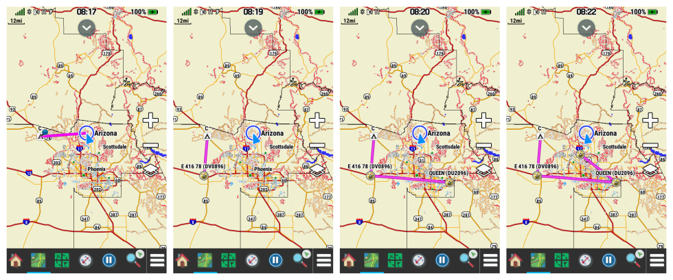
Selecting 'Add as Via Point' after entering
coordinates for a geocache 'Next Stage' may result in the Map page
magenta route line either (A) Not displayed on the map page, or (B)
Displayed only between the previous destination and current next stage
coordinates. [example]
[Related: Bug 78,
Bug 92,
Bug 117] |
|
[1310] [1320] [1480] [1500] [1510]
[1520] [1650] [1670] [1810] [1890] [1900] [1910] [1920] [2030]
[2050] [2270] [2310] [2330] [2410] [2420] [2430] [2450] [2470] [2510] |
| 117. |
Selecting 'Set as New Destination' after
entering coordinates for a geocache 'Next Stage' may result in the Map
page magenta route line either (A) Not displayed on the map page, or (B)
Displayed only between the previous destination and current next stage
coordinates. [example]
[Related: Bug 78,
Bug 92,
Bug 116] |
|
[1310] [1320] [1480] [1500] [1510]
[1520] [1650] [1670] [1810] [1890] [1900] [1910] [1920] [2030]
[2050] [2270] [2310] [2330] [2410] [2420] [2430] [2450] [2470] [2510] |
| 118. |
Progress bar numeric values below 55% are not visible in night mode. [example
1] [example
2] [Gr] |
|
[1090]
[1210] [1310] [1320] [1480] [1500] [1510] [1520]
[1650] [1670] [1810] [1890] [1900] [1910]
[1920] [2030] [2050] [2270] [2310] [2330] [2410] [2420] [2430] [2450]
[2470] [2510] |
| 119. |
The selections 'None' and 'User' in [Setup > Position Format > Map
Datum] are always displayed in English, regardless of language
configured. [Gr] |
|
[1090] [1210] [1310] [1320] [1480]
[1500] [1510] [1520] [1650] [1670] [1810] [1890] [1900] [1910]
[1920] [2030] [2050] [2270] [2310] [2330] [2410] [2420] [2430] [2450]
[2470] [2510] |
| 120. |
The Satellite Dashboard unit indicators for 'GPS Elevation' and 'GPS
Accuracy' may be displayed partially off screen. [Gr] |
|
[1090] [1210] [1310] [1320]
[1480] |
| 121. |
Adding a via point to an active route clears/resets the routing method
to the default value for the active profile. [Gr] |
|
[1320] [1480] [1500] [1510] [1520]
[1650] [1670] [1810] [1890] [1900] [1910] [1920] [2030] [2050]
[2270] [2310] [2330] [2410] [2420] [2430] [2450] [2470] [2510] |
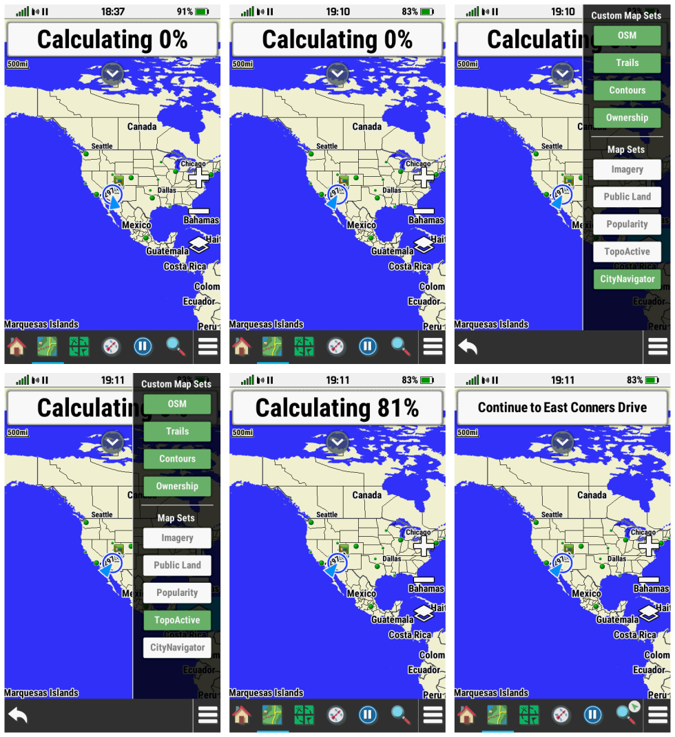
| 122. |
Selecting [Where To? > {any destination} > Go] frequently results in
'Calculating 0%' displayed indefinitely. [example]
[Gr] |
|
[1320]
[1480] |
| 123. |
'Auto Pause HH:MM:SS' message is not cleared from the display when
activity recording resumes. [Gr] |
|
[1320]
[1480] |
| 124. |
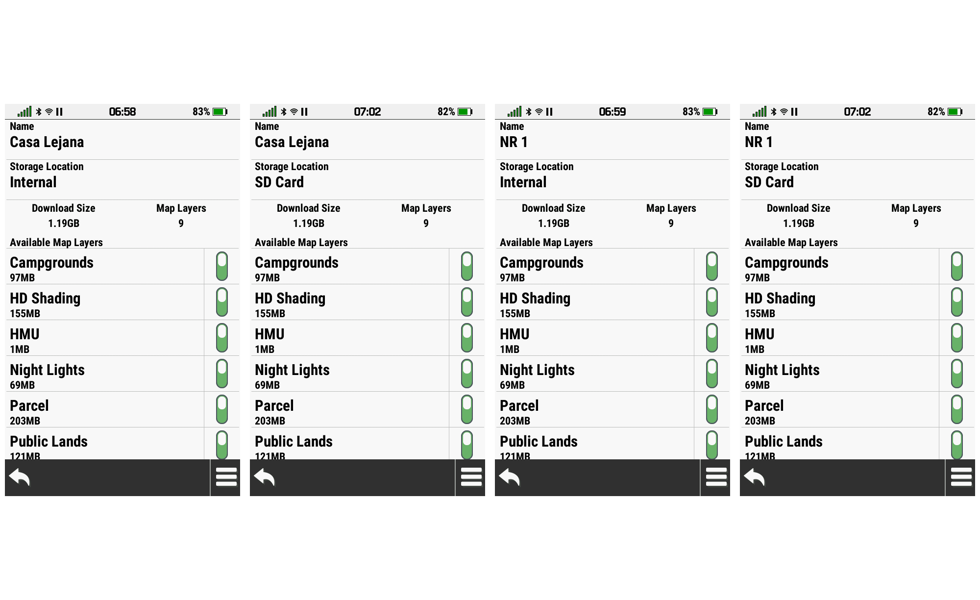
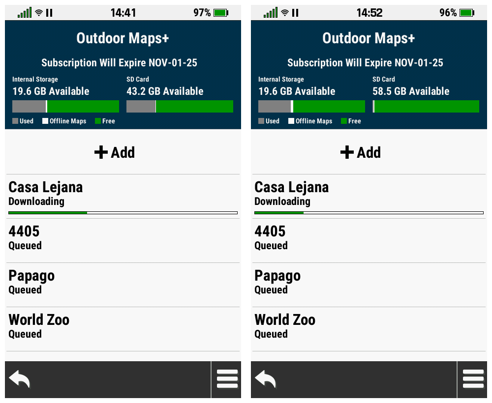
Opening [Map Manager > Outdoor Maps+ > Menu >
Configure Raster Maps] results in ghost entries being displayed and may
also result in
Crash 13. [Gr] |
|
[1480] [1500] [1510] [1520] |
| 125. |
Selecting [Download Size] or [Map Layers] in
[Map Manager > Outdoor Maps+ > Add Satellite Imagery] while the display
is in 'Night Mode' results in some text being obfuscated. [example]
[Gr] |
|
[1480] [1500] [1510] [1520] [1650] [1670]
[1810] [1890] [1900] [1910] [1920] [2030] [2050] [2270] [2310] [2330]
[2410] [2420] [2430] [2450] [2470] [2510] |
| 126. |
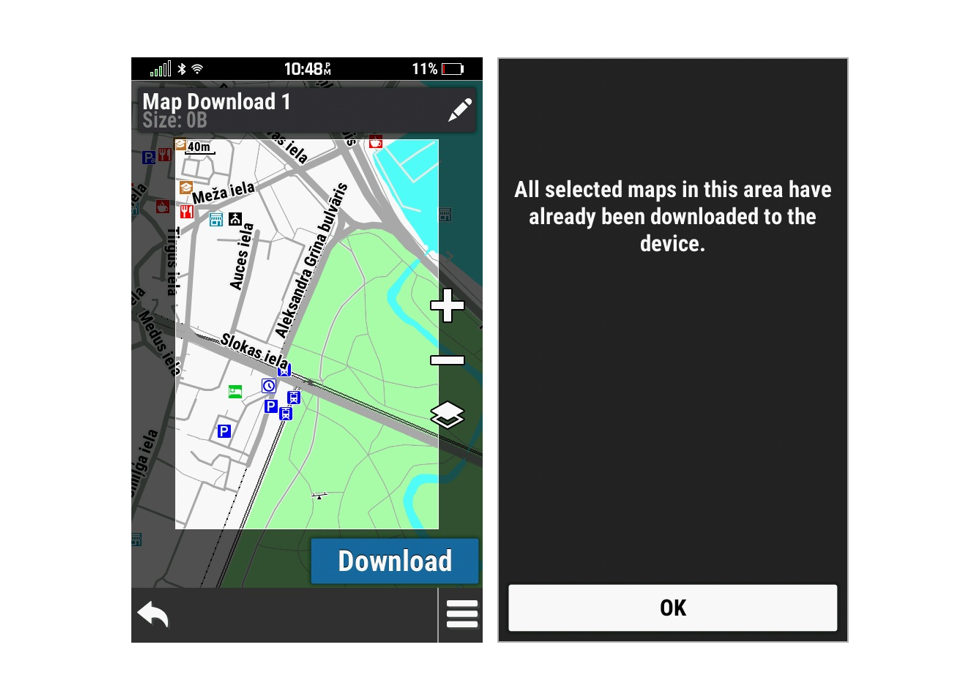
Opening [Map Manager > Outdoor Maps+ > +Add]
frequently results in the message 'Cannot connect to Outdoor Maps+
servers.' - and may be followed by
Crash 12.
|
|
[1480] [1500] [1510] [1520] [1650] |
| 127. |
Opening [Map Manager > Outdoor Maps+ > +Add]
frequently results in the message 'Requesting Map Update Data' being
displayed indefinately, requiring the user to remove the battery to
restart the device. |
|
[1480] [1500] [1510] [1520] |
| 128. |
Opening [Map Manager > Outdoor Maps+ > +Add]
frequently results in a device location reset similar to the initial
power on sequence with audible and visual warnings for all nearby
proximity points (etc.) while the 'Requesting Map Update Data' message
is being displayed. |
|
[1480] [1500] [1510] [1520] [1650] [1670]
[1810] [1890] [1900] [1910] [1920] [2030] [2050] [2270] [2310] [2330]
[2410] [2420] [2430] [2450] [2470] [2510] |
| 129. |
Opening [Map Manager > Outdoor Maps+ > +Add] and
rotating the device between portrait and landscape mode frequently
results in display errors. [example]
[Gr] |
|
[1480] [1500] [1510] [1520] |
| 130. |
The Map Point Information page may be
unresponsive or slow to respond. [Gr] |
|
[1480] [1500] [1510] [1520] [1650] [1670]
[1810] [1890] [1900] [1910] [1920] [2030] [2050] [2270] [2310] [2330]
[2410] [2420] [2430] [2450] [2470] [2510] |
| 131. |
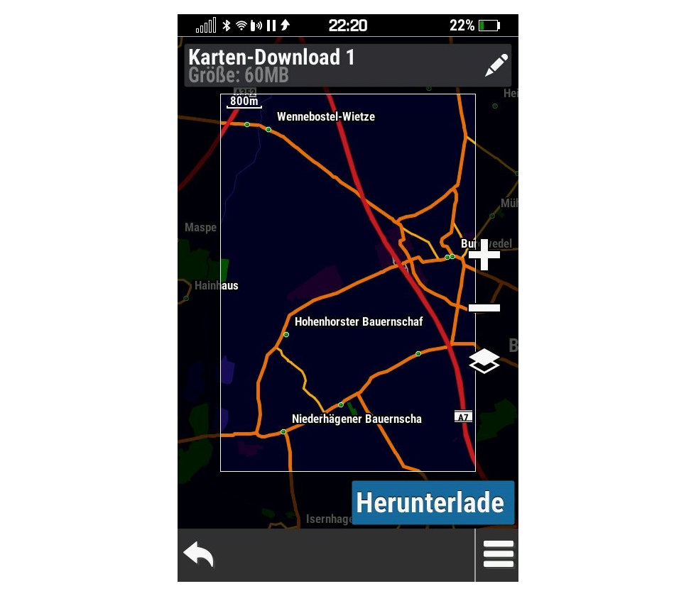
Opening [Map Manager > Outdoor Maps+ > +Add] with
German language enabled results in 'Herunterladen' being incorrectly
displayed as 'Herunterlade'. [example]
[Gr]
[correction requires text v2.80 or
newer] |
|
[1480] [1500] [1510] [1520] |
| 132. |
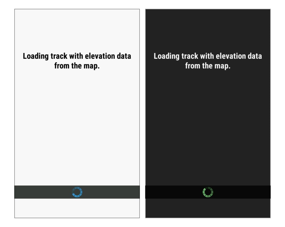
Selecting [Where To? > Tracks > Choose Track >
{select track}] results in a 'Loading track...' screen with a
non-transparent Progress Wheel background displayed in both Day and
Night modes. [example]
[Gr] |
|
[1500] [1510] [1520] |
| 133. |
Selecting any Tab after panning the map in the
Active Weather page results in the map being recentered on the user's
current location. |
|
[1480] [1500] [1510] [1520] [1650] [1670]
[1810] [1890] [1900] [1910] [1920] [2030] [2050] [2270] [2310] [2330]
[2410] [2420] [2430] [2450] [2470] [2510] |
| 134. |
Favorite Menu may incorrectly place focus on
Geocache icon with Map page displayed. [example]
[example] [Gr] |
(2644) |
[1480] [1500] [1510] [1520]
[1650] |
| 135. |
When attempting to
send a course via Share Wirelessly, the device instead enters navigation
mode. |
|
[1050] [1080] [1090] [1210] [1310]
[1320] [1480] [1500] [1510] [1520] [1650] [1670] [1810] [1890]
[1900] [1910] [1920] [2030] [2050] [2270] [2310] [2330] [2410] [2420]
[2430] [2450] [2470] [2510] |
| 136. |
GGZ files may not be properly indexed resulting is lost data that is not
available on the device. |
|
[310] [420] [530] [640] [710] [820] [840] [850]
[920] [1050] [1080] [1090] [1210] [1310] [1320] [1480] [1500]
[1510] [1520] [1650] [1670] [1810] [1890] [1900] [1910] [1920]
[2030] [2050] [2270] [2310] [2330] [2410] [2420] [2430] [2450] [2470] [2510] |
| 137. |
Map page data may appear distorted when viewed at lower
map scale values. [example
1]
[example
2] [garmin]
[update v20.30 improves vector
map scaling while raster maps remain distorted] |
|
[1480] [1500] [1510] [1520] [1650]
[1670] [1810] [1890] [1900] [1910] [1920] [2030] [2050] [2270] [2310]
[2330] [2410] [2420] [2430] [2450] [2470] [2510] |
| 138. |
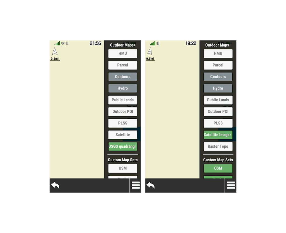
The Satellite Imagery button in the
Map page Map Layer Menu is randomly displayed
with different titles, including 'Satellite', 'Satellite Imag',
and 'Satellite Imager'. [example]
|
|
[1480] [1500] [1510] [1520] [1650] [1670]
[1810] [1890] [1900] [1910] [1920] [2030] [2050] [2270] [2310] [2330]
[2410] [2420] [2430] [2450] [2470] [2510] |
|
139. |
The Raster Topo button in the Map page Map
Layer Menu is randomly displayed with different titles, including
'Raster Topo', 'USGS Quad', and 'USGS quadrangl'. [example]
|
|
[1480] [1500] [1510] [1520] [1650] [1670]
[1810] [1890] [1900] [1910] [1920] [2030] [2050] [2270] [2310] [2330]
[2410] [2420] [2430] [2450] [2470] [2510] |
| 140. |
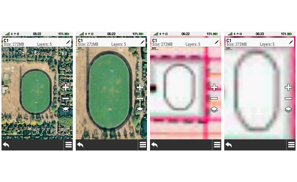
The Outdoor Maps+ Main Menu lists JNX maps that: (A) are partial
components of downloaded map sets, (B) cannot be enabled or disabled
individually, and (C) should not be displayed in this menu. |
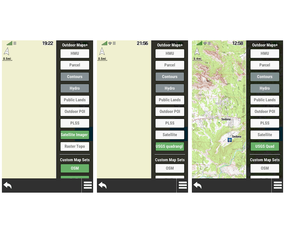
(2596) (2733) |
[1480] [1500] [1510] [1520]
[1650] [1670] [1810] [1890] [1900] [1910]
[1920] [2030] [2050] [2270] [2310] [2330] [2410] [2420] [2430] [2450]
[2470] [2510] |
| 141. |
Satellite Imagery downloads may fail after
installing update v18.90.
[example]
[Gr]
[garmin] |
|
[1890]
[1900] |
| 142. |
Map Manager may randomly report incorrect storage locations for
downloaded maps. [example]
[Gr] |
|
[1900] [1910] |
| 143. |
Map Manager may randomly enable and/or disable Garmin Custom Maps loaded
to the device. [Gr] |
|
[1900] [1910] [1920] [2030] [2050] [2270]
[2310] [2330] [2410] [2420] [2430] [2450] [2470] [2510] |
| 144. |
The Automotive Turn data field is always displayed blank and does not
function as intended. [adv] |
|
[2030] [2050] [2270] [2310] [2330] [2410]
[2420] [2430] [2450] [2470] [2510] |
| 145. |
Widgets may no longer be displayed when swiping the Status Menu after
installing update v20.30. [Gr] |
|
[2030] [2050] [2270] [2310] [2330] [2410]
[2420] [2430] [2450] [2470] [2510] |
| 146. |
Names for routes loaded to the device may be displayed with scrambled
text. [Gr] |
|
[2050] [2270] [2310] [2330] [2410] [2420]
[2430] [2450] [2470] [2510] |
| 147. |
Routes loaded to the device may not appear in route selection menus. [Gr] |
|
[2050] [2270] [2310] [2330] [2410] [2420]
[2430] [2450] [2470] [2510] |
| 148. |
Maps with transparent layers may fail to display properly at
all zoom levels after installing update v22.70. |
|
[2270] [2310] [2330] [2410] [2420] [2430]
[2450] [2470] [2510] |
| 149. |
All user data (vector maps, custom maps, photos, adventures, waypoints,
tracks, routes, courses, geocaches, POi's, etc.) may be erased from the
installed microSD card without warning after installing update v22.70. [example] [Gr] |
(3078) |
[2270] [2310] [2330] [2410] [2420] [2430]
[2450] [2470] [2510] |
| 150. |
Maps pre-installed on micro SD cards may fail to appear in the Map
Manager menu after installing update v22.70. [Gr] |
|
[2270] [2310] |
| 151. |
Street names may no longer be displayed on the
Map page, regardless of user settings, after installing update v23.10. [Gr] |
|
[2310] [2330] |
| 152. |
[Map Manager > TopoActive Maps] no longer functional after updating
TopoActive maps via Garmin Express. |
|
[2330] [2410] [2420] [2430] [2450] [2470] [2510] |
| 153. |
Selecting 'Delete' for one Outdoor Maps+ map may result in the wrong map
being deleted from the device. |
|
[2330] [2410] [2420] [2430] [2450] [2470] [2510] |
| 154. |
Outdoor Maps+ map downloads may not index properly after download is
completed. [Gr] |
|
[2410] [2420] [2430] [2450] [2470] [2510] |
| 155. |
Outdoor Maps+ map layers may not appear in Map
page Map Layer Menu list, and may not be displayed properly on the Map
page when available and selected in the Map Layer Menu list. [Gr] |
|
[2410] [2420] [2430] [2450] [2470] [2510] |
| 156. |
Map data, relative to user position, may be heavily skewed while
manipulating the map page. [example]
[Gr] |
|
[2470] [2510] |
|
1. |
Include option to
auto-upload logs to geocaching.com as a draft ('Field Notes'), allowing the user
to edit them at a later time before publishing as a log. [Gr]
[groundspeak] |
|
|
|
2. |
Update unit
operation to
track and display 'DNF' geocaches using a 'Blue Frown' 'Geocache DNF.bmp'
symbol the user can modify via 'CustomSymbols'
directory. (Geocaching.com tracks DNF's, so should the Montana 7x0) |
|
|
|
3. |
Include function to enable
review and
editing of geocache log notes saved on the device. [Gr]
[Gr] |
|
|
|
4. |
Update Geocache
Descriptions to include
Attribute information. |
|
|
|
5. |
Update
the Geocaching page Map tab display (only - not the primary Map page) to
include a progress bar indicating GCLive download progress (not GC List
progress). [example]
[Gr] |
|
|
|
6. |
Add a function to sound a
user selected proximity alarm when within a user selected distance of a
geocache. [groundspeak] |
|
[410] |
|
7. |
Include both hddd°mm.mmm' and hddd°mm.mmmm'
options in [Setup > Position Format].
[groundspeak]
|
|
|
|
8. |
Update device
operation to display
geocache log dates in format specified by user. [Gr] |
|
|
|
9. |
With [Setup >
Display > Battery Save = On], it is impossible for the user to determine
if the GPSr is in Battery Save Mode or powered off. Pressing the Power
Button either exits Battery Save Mode or starts an undesired boot
sequence if powered off. Perhaps the unit could pulse the Notification
LED (two quick pulses every 5 or 10 seconds) to indicate the unit is
still powered on? |
|
|
|
10. |
Incorporate a new 'Satellite Availability' or 'Satellite Visibility'
page for current and future models. [examples] |
|
|
|
11. |
Add Elevation Delta to Map
page Info Box (currently only shows direction and distance) for cursor
position when panning map. [Gr] |
|
|
|
12. |
Add
'Full Scale' option to Elevation plot menu to automatically adjust the Y
axis such that the top of the graph display is equal to the highest
recorded value and the bottom of the graph display is equal to the
lowest recorded value. [Gr] |
|
|
|
13. |
Introduce a simple notepad page that allows the user to create, edit and
save geo-tagged text notes for future reference. [Gr]
[garmin] |
|
|
|
14. |
Include a menu option to 'Download BirdsEye' directly from the Map page menu for
all devices equipped with BirdsEye Direct. |
|
[1650] |
|
15. |
Include an option to display time as HH:MM:SS in Status Bar. [Gr] |
|
|
|
16. |
The Elevation
Plot application currently allows the user to view 'Elevation/Time',
'Elevation/Distance', 'Barometric Pressure', or 'Ambient Pressure' data.
Please include option to view 'Temperature', 'Heart Rate', 'Cadence',
'Calories' and other data, when available. [Gr] |
|
|
|
17. |
Incorporate Ambient
Pressure and Barometric Pressure data (when enabled) into recorded track
data. |
|
|
|
18. |
Improve Saved Tracks list
function to include a 'Show/Hide' toggle button with each track in the
list, similar to Map Selection Menu. |
|
[800] |
|
19. |
Include functionality to
export/share GPSr Calendar database with external software. [garmin.de] |
|
|
|
20. |
Update Sight 'N' Go
page on camera equipped devices to (A) display a 'rolling
tape' heading indicator along bottom of screen (profile or landscape),
with the current heading displayed oversize in center of 'rolling tape'
display, with a pointer icon (crosshair) centered on the screen, while
(B) displaying the live camera image behind the 'rolling tape' Sight 'N'
Go graphic. |
|
|
|
21. |
When using [Where To? >
Round-Trip Routing], the device indiscriminately chooses either a
clockwise or counter-clockwise direction for each suggested 'Round-Trip
Route', and no option exists to reverse the direction of the suggested
route. Please include a 'Reverse Route' option for each 'Round-Trip Route'
as the user may discover any number of reasons that require
a suggested route be
followed in the reverse direction. |
(1741) |
|
|
22. |
When using [Where To? >
Round-Trip Routing], no option exists to save each
suggested 'Round-Trip Route' for future use. Please include a
'Save Route' option for each 'Round-Trip Route',
allowing future access via the Route Planner
page. |
(1741) |
|
|
23. |
Include a 'Status Bar Notification Icon' to indicate current 'Recording
Controls' Activity Recording status, similar to inReach
Tracking notification icon (active " ",
paused " ",
paused " ",
and stopped " ",
and stopped " "). "). |
(1764) |
[800] |
|
24. |
Update
Photo Information page to include Camera Heading information. |
|
|
|
25. |
Add
support for Garmin Varia radar. [garmin] |
|
|
|
26. |
Add
support for a default geocache found log text file (Garmin\DefaultLog.txt)
that when present is used to auto-populate [Geocache Found > Edit
Comment] logs. [garmin] |
|
|
|
27. |
Include an option for users to 'opt
out' of seeing the 'inReach Registration Nag Screen' at every power on
event. [garmin] |
|
|
|
28. |
Link the display of track
navigation
high/low point symbols to
the
Map page user waypoint zoom value, providing
the user with some control over when they are displayed. |
(1978) |
|
|
29. |
Improve
geocache database functionality to download GCLive data for geocaches
already present in GPX/GGZ format, allowing the user to choose between
using GCLive or GPX/GGZ files when enabling or disabling 'Live Data' in
[Geocaching > Filters > Geocache Files]. |
|
|
|
30. |
Improve 'pinch-to-zoom' to
allow more zooming capability
when reviewing photos or images. |
|
|
|
31. |
Provide additional inReach
data sync options that do not require a smartphone or mobile app. [garmin] |
|
|
|
32. |
Enhance POI Alerts to include a 'Flash Display'
option for users that: [Gr]
- Operate the device in noisy environments
- Operate the device in sound sensitive environments
- May be hearing impaired.
|
|
|
|
33. |
Complete FIT file support to provide
full import/export/navigation functionality similar to other fitness
products. [Gr] |
|
[1050] |
|
34. |
Add 'Download Geocaches' selection to Map page option menu. |
|
|
|
35. |
Add capability to manage files on device from a PC or Mac via
Wi-Fi. [Gr] |
|
|
|
36. |
Improve FIT (activity) and GPX (tracklog) file naming schema
consistency by updating all Garmin Outdoor GPSr to name GPX Tracklog
files based on the Start Time instead of the End Time, similar to how
FIT files are already named. |
(2099) |
|
|
37. |
Enhance Geocache Proximity Alert function to honor all user configured
geocache filter settings. |
(2100) |
[800] |
|
38. |
The Geocache Proximity Alert
feature currently only allows the user to 'Dismiss' an alert. Please
also include the option to 'Begin Navigation' to the displayed geocache.
[Gr] |
|
|
|
39. |
Please include a 'Show/Hide
Geocaches' selection to the Map page option menu, similar to the
Geocache page Map tab 'Show/Hide Waypoints' option menu selection. |
|
|
|
40. |
Please include 'Most Recent'
selection in Waypoint Manager 'Sort' option menu, similar to the existing
Track Manager sort option menu. [Gr] |
|
|
|
41. |
Please add an option allowing the user to configure the total number of
geocaches used to populate the Geocache List. |
|
|
|
42. |
Please add 'Refresh Geocache' selection to the Active Geocache tab
option menu. |
|
|
|
43. |
Maintain quick and easy access to Sensor Setup page by not hiding
'Sensors' on the Status page when none are enabled or connected. |
|
|
|
44. |
Please introduce a profile dependent setting to configure the speed when
the compass switches from magentic to GPS operation. [Gr] |
|
|
|
45. |
Please add an 'Auto' or 'Full Scale' selection to the Altimeter page
scale options that results in the upper pane elevation plot being
rendered so the lowest elevation value is aligned to the bottom edge and
the highest elevation value the top edge. |
|
|
|
46. |
Restore wallpaper support for Montana 7x0 Main Menu page. [Gr] |
|
|
|
47. |
Include a user configurable
Map Layer Menu option to show/hide 'User Waypoints' on the Map page. |
|
|
|
48. |
Include a user configurable
Map Layer Menu option to show/hide 'Geocaches' on the Map page. |
|
|
|
49. |
Include a user configurable
Map Layer Menu option to show/hide 'POI's' on the Map page. |
|
|
|
50. |
Please allow a Custom Waypoint Symbol to be configured to replace the
small square icon currently displayed over waypoints that are part of an
active route. [Gr]
[Related: Bug 71] |
|
|
|
51. |
Please add WPA3 support for Wi-Fi networks. [Gr] |
|
|
|
52. |
Include 'Portrait Controls' option similar to 'Landscape Controls' in
[Setup > Display > Appearance] menu. [Gr] |
|
|
|
53. |
Please include a 'Go Home' shortcut similar to what is available on many
current and previous Garmin devices. [Gr] |
|
|
|
54. |
Please include an option to hide social media contacts for users that
have no intention of using them. |
|
|
|
55. |
Add more user configurable custom map sets to
the
Map Layer Menu displayed on the Map page. [Gr] |
|
|
|
56. |
Please add capability for user to send coordinates for any waypoint
location via inReach. [garmin] |
|
|
|
57. |
Please add 'Ascent to Next', 'Ascent to Dest', 'Descent to Next', and
'Descent to Dest' data fields.
[Gr] |
|
|
|
58. |
Please add support for e-bike ANT sensors (similar to Edge series). [Gr] |
|
|
|
59. |
Please provide option to display directional chevrons for courses,
tracks and routes. |
(2742) |
|
|
60. |
Please add support for third party JNX raster maps. |
|
|