|
|
|
|
|
|
|
|
|
Overview |
|
|
|
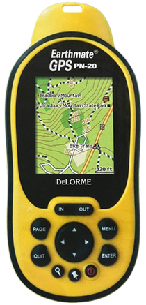
GPS for wherever you go. On Trail.... On Road... On
Water.... |
|
|
|
An All-in-One Handheld GPS Solution from DeLorme: |
- NMEA-compliant 12-channel GPS receiver
- Fast acquisition times, outstanding signal retention
- High-resolution 2.2" TFT color screen for total clarity
under a variety of lighting conditions
- 75 MB of user-available internal flash memory
- SD card slot for up to 2 GB additional memory
- Holds up to 10 tracks (10,000 points per track), 1,000
user-defined waypoints, and 50 routes
- Aerial imagery available for free download
- Pre-loaded worldwide highway/major road base map
- Waterproof to IPX-7 standard
- Impact-resistant rubberized housing
- On-device road routing
- Runs on 2 AA batteries (included) or available
lithium-ion rechargeable battery
- WAAS-enabled
- Device dimensions: 2.43" W x 5.25" H x 1.5" D
- Weight 5.35 oz.
|
|
|
|
Why the All-in-One PN-20 Handheld? |
- Maps Included: No extra maps to buy.
Includes DeLorme Topo USA 8.0 DVD software with full,
updated U.S. topographic & street maps to export as needed
to your PN-20. Also includes an on-device highway-level
world base map.
|
- FREE Aerial Imagery Downloads: Includes
$100 worth (400 sq. km) of DeLorme Aerial Data Packets of
your U.S. areas of interest. Download Aerial Data Packets
containing black & white aerial imagery (DOQQs), Sat-10
colorized satellite imagery, and scanned USGS 7.5-minute
quads using Topo USA’s NetLink tab.
|
- Multiple Views of the Same GPS Location:
On-device data layering lets you select which map or imagery
type to see of your GPS location. Switch among data types to
gain a comprehensive view of where you are - it’s
revolutionary and provides a whole new level of geographic
detail.
|
- Bright Color Screen: Works in bright
sunlight to total darkness. Sharp brand screen featuring the
latest transflective screen technologies to maximize
visibility under a variety of lighting conditions.
|
- Rugged and Waterproof: Conforms to
IPX-7 waterproof standard with impact-resistant rubberized
housing for a solid grip. Concealed battery compartment with
SD card slot. Includes two AA batteries.
|
- High-Performance Technology: Features
STMicroelectronics chipset with SiGE RF front-end and
DeLorme firmware for outstanding signal acquisition and
retention. Works equally well under dense foliage or
in-vehicle.
|
- Easy Exchange of Maps, Tracks, and Waypoints:
Exchange pre-cut multi-state routable regions between Topo
USA on the desktop to the GPS, or select only the specific,
customized areas you want--topographic maps and imagery.
Exchange routes, tracks, and waypoints between the GPS and
Topo USA (two-way transfers).
|
- Extensive On-Device Memory: 75MB of
internal flash memory available in addition to the preloaded
world base map. Holds up to ten tracks (10,000 points per
track); 1,000 user-defined waypoints; and 50 routes. SD slot
also available.
|
- Powerful Topographic Software Included:
The included Topo USA PN-20 software is loaded with
additional capabilities for use on a desktop PC. Create
automatic road and trail routes, elevation profiles, and
realistic 3-D flyovers. No extra charge to you--a $99.95
retail value by itself!
|
|
|
|
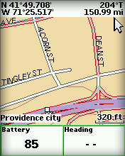
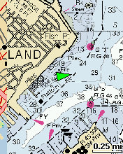
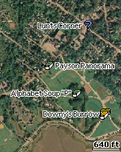
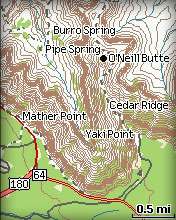
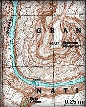
Sample Screens |
|
|
|
|
|
|
|
Specifications |
|
|
|
Part Number |
AE-7843-201 |
|
Unit Dimensions |
2.43" x 5.25" x 1.50" (6.2 cm x 13.3 cm x 3.8 cm) |
|
Display Size |
1.38" x 1.75" (3.5 cm x 4.4 cm), 2.2" (5.6 cm) diagonal |
|
Display Resolution |
176 x 220 |
|
Display Type |
65K
Color Transflective TFT |
|
Weight |
5.35 oz (152 g) without batteries |
|
Battery Type |
AA x 2 or Rechargeable Li-Ion |
|
Battery Life |
22 hours (Lithium AA), 14 hours (Alkaline AA), 11 hours
(Rechargeable Li-ion) |
|
Sleep When Stationary Mode |
No |
|
Stealth Mode |
No |
|
Button Lock |
No |
|
Operating Temperature |
-4° F to 167° F (-20° C to 75° C) |
|
Storage Temperature |
-49° F to 212° F (-45° C to 100° C) |
|
Impact Resistance |
MIL STD 810F |
|
Waterproof |
IPX7 |
|
Floats |
No |
|
Interface |
Proprietary 8-pin USB cable |
|
Dual-Core Processor |
No |
|
GPS Receiver |
STM NMEA compliant (12 Channel) |
|
GPS Antenna |
Patch |
|
GPS Constellations |
GPS +
WAAS |
|
GPS Kalman Filter |
Yes |
|
GPS Position
Accuracy (95%) |
< 15 meters (GPS), < 3 meters (WAAS) |
|
GPS Velocity Accuracy |
0.05 meter / second steady state |
|
GPS Hot Start |
< 3 seconds |
|
GPS Warm Start |
< 38 seconds |
|
GPS Cold Start |
< 60 seconds |
|
GPS Update Rate |
1 / second, continuous |
|
Pairs With SPOT / inReach |
No |
|
Altimeter |
GPS |
|
Barometer |
No |
|
Compass |
GPS |
|
Accelerometer |
No |
|
Routes |
50 |
|
Tracks |
10 (10,000 points per track) |
|
Waypoints /
Geocaches |
Unlimited (1,000 per GPX) |
|
Almanac Information |
Yes (Tides, Sun and Moon, Hunt and Fish) |
|
Point-to-Point Navigation |
Yes |
|
On Road Navigation |
Yes |
|
Trip Info |
Yes |
|
Track Log |
Yes |
|
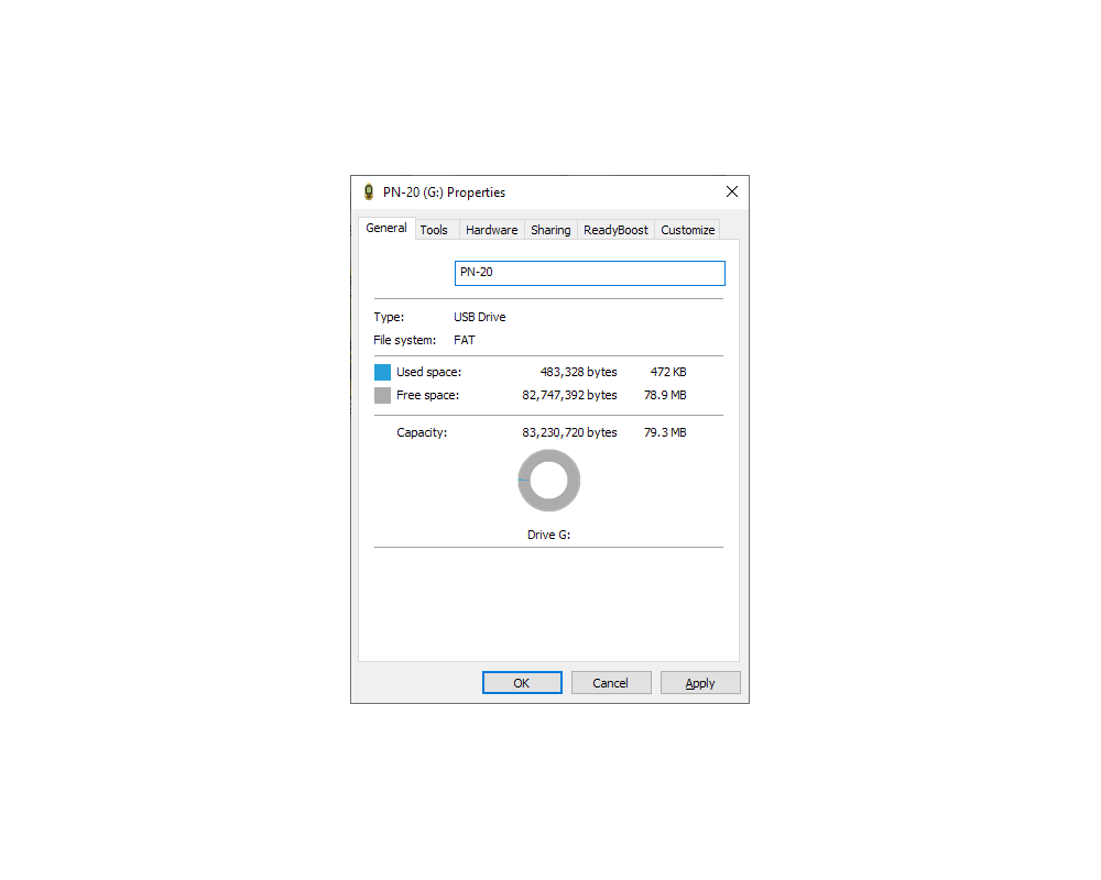
Internal Memory |
79.3 MB |
|
Expandable Memory |
SD card (max 32 GB) |
|
Pre Loaded Base Map |
Yes (basic highway-level worldwide basemap) |
|
Can
Add Maps |
Yes |
|
|
|
|
|
Documents |
|
|
|
Earthmate PN-20 FAQ |
|
Earthmate PN-20 Getting Started |
|
Earthmate PN-20 User Manual |
|
Earthmate PN-20 User Manual (update 1.5) |
|
How to Send Maps to an Earthmate PN-20 |
|
Earthmate PN-Series
Features |
|
Compare Earthmate PN-20 vs PN-30 vs PN-40 |
|
|
|
|
|
Media |
|
|
|
05FEB07 - DeLorme Earthmate GPS PN-20 Introduction |
|
06NOV07 - DeLorme
Topo USA 7.0 |
|
24JUN09 -
Streamlined Geocaching for
Earthmate PN-Series GPS with Cache Register Widget |
|
|
|
|
|
Update History |
|
|
|
Check Firmware Version |
|
|
|
1.6 (29APR09) (PN-20) |
- Geocaching support:
- Added a Geocaching page, which separates Geocaches from
Waypoints. This page allows you to sort Geocaches by
Name/Distance/Logged/Not Logged.
- Geocache/Waypoint Comment character limit increased from
800 to 2,000 characters. Please Note: The current version of
the Send to GPS plugin does not yet have this support. We
are working on a new version of Send to GPS that will send
2000 characters. When Topo USA 8.0 and the Cache Register
application are released, they will also include this
support.
- Added graphics to the Geocache Comment page which
indicate Size, Difficulty and Terrain.
- Difficult/Terrain and Cache Size Info Fields
(non-editable) now display directly within the Geocache
Details page (as well as their standard location within the
Geocache Comment).
- Moved the Hint to the bottom of the Comment for
Geocaches sent from the Send to GPS Plugin and Cache
Register.
- Added a View Hint menu option to the Geocache Details
page.
- Added new Geocaching Symbols to match those used by
Geocaching.com.
- Field Notes support allows you to create field notes
directly on the PN-20, which can then be uploaded through
your account at www.geocaching.com.
- Added a View Field Notes menu option to the Geocache
page. Note that this is View only. You cannot edit existing
Field Notes on the device.
- Geocaching wizard steps you through the process of
Routing to a Geocache, Logging your Geocache find, Entering
a Field Note then moving on to the next Geocache you want to
find (closest, or selected from the list).
- Waypoints/Geocaches:
- Geocaches and Waypoints pages now display the number of
each on the page's Title.
- General improvements to Waypoints and Geocaches to
improve stability, reduce corruption and prevent duplicates.
- Routing:
- Road and Direct have been replaced with Drive and Hike
in all routing scenarios.
- Routing method drop-down menu on the Create Route page
has been replaced by a pop-up asking if you want to Drive or
Hike after hitting the Navigate button.
- Prepared routing engine for release of Topo USA 8.0.
- Device UI:
- Adjustments to font sizes to make data within info
fields easier to read.
- Remapped device buttons while virtual keyboard is
displayed. In Button: Deletes last character. Out Button:
Space. Find Button: Shift. Mark Button: Jumps highlight to
OK.
- Text Display change so that seconds display in larger
font until hours are available, then they return to small
font.
- Added single press of arrow key on Map Page to enable
the backlight w/o entering Pan mode.
- Current field is now highlighted in list when Changing
Info Field.
- Added a Map Point Management button to the Map Setup
menu. This brings up a page where you can control how POIs'
/ Waypoints / Geocaches display on the map. You can set them
to display with Large or Small symbols, and control what
Zoom levels they display at. There is also a new option here
to Hide Logged Caches on the map (even though it can be fun
to see all those Smilies, it can be useful to have a view
that only shows Not Logged only).
- Satellites Page:
- Added Current Time to Satellites Page.
|
|
|
|
1.5 (31JUL08) (PN-20) |
|
Note: The 1.5 firmware update includes updates
from all previous firmware updates. Changes in this update are
noted in bold below. |
- New Features
- Updater:
- Updater complies with Windows Vista operating system for
Earthmate GPS PN-20 firmware and data.
- Base Data:
- Updated base maps and regional maps work with Topo USA
7.0.
- Device Setup:
- Provides ability to enter and display owner information.
- Option to mute sound available.
- Saves user preferences between firmware updates.
- Ability to set a unique datum for both
Coordinates:Primary and Coordinates:Secondary.
- Find:
- "Search is Complete" displays at the end of the results
list when all results have been returned.
- Added GIS layers (with XMap 6 and later versions) and
draw layers as unique categories when performing a Find.
- Hunt/Fish:
- A new Hunt/Fish page is available.
- Map:
- Able to display draw objects cut from Topo USA 7.0 over
raster data.
- Includes major and minor POIs from Topo USA 7.0.
- Able to view nautical chart data cut from Topo USA 7.0.
- Able to view Township/Range polygons in vector data cut
from Topo USA 7.0.
- Polygons created with the measure tool can include area
information.
- The Enter button can now perform a map pick based upon
current GPS location, rather than having to enter pan mode.
- User objects (Waypoints/Tracks/Routes/Draw/GIS) are
listed at the top of the Multiple Objects list when you
perform a pick on the map.
- New Map Style option added in Map Setup allows you to
choose between Topo View and Street View. In Topo view, all
map objects are drawn. In Street View, contour lines and
land-use/land-cover polygons are omitted.
- New Show Hybrid Maps option in Map Setup allows vector
data (points/lines) to display on top of imagery.
- Added support for GIS layers created in XMap 6 and later
versions.
- Route:
- View/Hide is available for routes. This allows you to
view a route on the map (road routes viewed on PN-20 will
still need to calculate) without entering navigate mode.
- Support added for automatic back-on-track recalculation
for direct and road routes.
- Two-point direct routes continually update from the
current GPS location to the route finish (rubber band
routing).
- Added audio turn alerts for use with automatic
back-on-track direct routes.
- Text:
- When editing text input, the In button deletes one
character at a time.
- Tracks:
- Option to begin a new track log when the current log is
full available.
- When saving the active track, options to reset running
trip information are available.
- Waypoints:
- Up to 800 characters allowed in the comments section.
- Ability to hide waypoints below a zoom level you select.
- Ability to average waypoints multiple times.
- Ability to reposition existing waypoints to the current
GPS location.
- A new option allows you to always display small waypoint
symbols.
- Full page view for waypoint comments is available. From
the Waypoint Details page, choose Menu...View Comment
Details.
- Current Symbol is the default highlight when you enter
the Waypoint Symbol list. This makes it easier, for example,
to change a Geocache symbol to a Geocache Found symbol.
- Enhancements
- Device Setup:
- Info field names updated to match menu labels when
possible.
- DST setting text changed to "Enable Daylight Saving."
Enabling this setting allows the device to account for
Daylight Saving Time. This is a manual setting that you
should change at the appropriate times of year.
- Device UI:
- New rules for text editing: When editing existing text,
entering edit mode highlights entire text, and the left and
right arrows move the cursor to the beginning or end of the
text.
- NAD27 Conus label changed to NAD27 Continental US.
- Warning popup message displays with final battery
warning.
- Find:
- Improved Find performance using Topo 7 maps.
- Find remembers results when returning to the Find
Results page after pressing the Quit button.
- Find remembers search field entries between searches.
- Limited the number of characters allowed when typing in
City/Name fields.
- Find performance improved.
- The menu item ?History? is now named ?Recent Finds?.
- For Address by Name searches, "Street#" changed to
"Building Number" and "Name" changed to "Street Name."
- The Find By Name requires only a single character in the
Name field to trigger the alphabetic results list.
- Changes to the Find Menu more clearly indicate current
the Find Mode (Near Map Center/By Name) and clarify how to
switch between modes. These changes also apply to the Begins
With and Contains options when in Find By Name mode.
- Find accepts full compass directions in street names.
"East Main St" and "E Main St" work the same in a search.
- Map:
- The measure tool can create a polygon with area
information.
- When panning the map and then visiting the Sun/Moon or
Tides pages, press the Quit button to return to the Map
page, centered on the last pan location.
- To improve readability when viewing ratios for map
scale, K is used for thousands and M is used for millions.
- When hovering over a contour line, the elevation and the
correct units of measurement appear in the pick text.
- Improved drawing of Unimproved Local Roads, Intermittent
Streams, and Four Wheel Drive Trails.
- Able to view Regional Maps through the Data Management
screen.
- Ability to now properly manage USA Topographic 2008/2007
and GIS layers through Manage Layers.
- Custom Raster moved higher in the Data Layerering list.
- ImageReg moved higher in the Data Layering list.
- Route:
- Route simulation enabled.
- Improved route calculation speed in urban areas.
- Support added for vias in routes transferred from Topo
USA 7.0.
- Improved device performance when a large number of
routes exist.
- When long, complicated routes are transferred from Topo
USA, the PN-20 no longer displays the error ?Error storing
route (Too many shape points.).?
- Route simulation allows selection of a simulation speed
(1X - 50X).
- Satellites Page:
- Improvements to GPS accuracy estimation when not using
WAAS.
- Satellite page text changes for increased clarity.
- Text Input:
- Modification to the keyboard layout ensures separation
between the Clear and Enter buttons.
- Tracks:
- "Start Recording New Track" is the default setting for
"When Track is Full" in Track Settings.
- When performing a track playback, you can select a
playback speed (1X - 50X).
- Waypoints:
- Modified the auto-naming functionality when creating a
new waypoint. The previous symbol and name is incorporated
in the newly created waypoint by default.
- Enforced declared limit of 1,000 waypoints on the device
when waypoints are transferred from the desktop.
- Bug Fixes
- Compass Page:
- Compass arrow gets stuck at points along a Direct Route.
- Device Setup:
- Earthmate GPS PN-20 boots correctly when GPS and WAAS
settings are disabled.
- Custom page order is correctly remembered when cycling
through pages.
- Device UI:
- Fixed reporting of Average Moving Speed in Info frames.
- Increased resolution to allow modification of Seconds
when viewing Deg, Min, Sec.
- Double focus issues in Pages have been addressed.
- Coordinate spin controls no longer allow numbers over
59.
- After editing a user object (route, waypoint, track),
and powering off the device before leaving the Details page,
the edits are saved.
- On a Details page, after receiving messages that a name
already exists, highlights properly appear to indicate the
active field.
- Find:
- Limited the number of characters allowed when typing in
City/Name fields.
- POI search results are no longer temporarily hidden when
a search is stopped and then continued.
- Contour lines are no longer returned during the Find?All
process.
- Find improvements to prevent crashes and instability.
- Fixed a problem with the highlight on the Find page.
Highlight now properly cycles through results after you view
a result, then quit back to results, then scroll up.
- Waypoint find results refresh if you edit a waypoint,
and then quit back to the Find results.
- "Searching>>>" no longer reports Bearing/Distance.
- Improvements to the way Address results are returned.
Address results are now returned in larger ranges (Example:
1-1299 E Fort Ave). If you search for a specific address,
and view the returned range, you are located to the correct
geographic position within that range.
- Improved Find search results for rivers/streams. This is
a partial fix only. The 2nd half of the fix will come in the
next version of the desktop application that creates the
maps being searched.
- Improved Find search performance.
- Improvements to Find by Name-Contains ensure results
match the specified criteria (searching for contains "blvd"
returns only results containing "blvd.")
- GPS:
- Periodic loss of GPS signal during a 3D is fix greatly
reduced.
- Map:
- Map text is properly shown when viewing seam between two
cut maps.
- Turn Off Imagery menu option no longer disables Topo6 or
Topo7 data.
- Deleting the last map package through the Data
Management screen no longer results in a crash.
- Viewing N90,W180 no longer resets device.
- Duplicate labels no longer display for some polygons.
- Owner Information:
- Selecting Restore Setup Defaults correctly resets the
owner information when restarting the device.
- Route:
- Correctly calculates direct routes when their names
contain non-alpha numeric characters.
- Improved Routing stability.
- Improved route following performance.
- Back on Track recalculations no longer produce corrupt
routes.
- Stopping navigation when in the Route Directions page no
longer causes an error.
- Improvement for the turn arrow while road routing. This
is a partial fix only. The second half of the fix will come
in the next version of the desktop application that creates
the maps used for routing.
- Routes can no longer be saved without a name.
- Tracks:
- Deleted tracks do not reappear.
- Track Details more closely match GPS Log File Details.
- Trip Info:
- Trip counters do not continue to increase when the GPS
is disabled.
- Distance traveled while the PN-20 is turned off is no
longer added to the device and trip odometers when the PN-20
is turned back on.
- Waypoints:
- Properly displays waypoint information with attached URL
information.
- No longer creates new, empty waypoints after all
waypoints deleted and device is shut down.
- Waypoints are required to have a name.
- When using UTM coordinates with a datum of NAD27 Conus,
leaving the edit mode of the coordinates field does no
longer modifies the waypoint coordinates.
- Pressing the Find button immediately after editing a
waypoint in the Waypoint Details page displays any updates
made to that waypoint while in the Waypoint Details page.
- A change to a waypoint name is correctly saved when
quitting the Waypoint Details page.
- Waypoints created from a map pick (using the cursor) are
now placed at the actual click position for line/polygon
objects. Previously they could end up at the center of the
object instead of where you clicked.
- Improvements made to waypoint averaging to prevent
estimated accuracy from increasing inappropriately.
- Waypoint comments are no longer lost or transferred to
different waypoints.
- Other:
- Continued support for Earthmate GPS PN-20 interaction
with Topo USA 6.0.
- Via support disabled. Vias will not appear on the
Earthmate GPS PN-20 and are not used in route recalculation.
- White spaces around cut imagery may still appear.
- Added support for SDHC (high capacity) cards. No known
card size limit.
- Sending draw layers to the PN-20 using the Exchange
dialog no longer causes errors.
- GIS and draw objects are now referred to as
"User-created Objects" instead of "DeLorme Application
Specific Features."
|
|
|
|
1.4 (11APR08) (PN-20) |
|
Note: The 1.4 firmware update includes updates
from all previous firmware updates. Changes in this update are
noted in bold below. |
- New Features
- Updater:
- Updater complies with Windows Vista operating system for
Earthmate GPS PN-20 firmware and data.
- Base Data:
- Updated base maps and regional maps work with Topo USA
7.0.
- Device Setup:
- Provides ability to enter and display owner information.
- Option to mute sound available.
- Saves user preferences between firmware updates.
- Ability to set a unique datum for both
Coordinates:Primary and Coordinates:Secondary.
- Find:
- "Search is Complete" displays at the end of the results
list when all results have been returned.
- Hunt/Fish:
- A new Hunt/Fish page is available.
- Map:
- Able to display draw objects cut from Topo USA 7.0 over
raster data.
- Includes major and minor POIs from Topo USA 7.0.
- Able to view nautical chart data cut from Topo USA 7.0.
- Able to view Township/Range polygons in vector data cut
from Topo USA 7.0.
- Polygons created with the measure tool can include area
information.
- The Enter button can now perform a map pick based upon
current GPS location, rather than having to enter pan mode.
- User objects (Waypoints/Tracks/Routes/Draw/GIS) are
listed at the top of the Multiple Objects list when you
perform a pick on the map.
- New Map Style option added in Map Setup allows you to
choose between Topo View and Street View. In Topo view, all
map objects are drawn. In Street View, contour lines and
land-use/land-cover polygons are omitted.
- New Show Hybrid Maps option in Map Setup allows vector
data (points/lines) to display on top of imagery.
- Route:
- View/Hide is available for routes. This allows you to
view a route on the map (road routes viewed on PN-20 will
still need to calculate) without entering navigate mode.
- Support added for automatic back-on-track recalculation
for direct and road routes.
- Two-point direct routes continually update from the
current GPS location to the route finish (rubber band
routing).
- Text:
- When editing text input, the In button deletes one
character at a time.
- Tracks:
- Option to begin a new track log when the current log is
full available.
- When saving the active track, options to reset running
trip information are available.
- Waypoints:
- Up to 800 characters allowed in the comments section.
- Ability to hide waypoints below a zoom level you select.
- Ability to average waypoints multiple times.
- Ability to reposition existing waypoints to the current
GPS location.
- A new option allows you to always display small waypoint
symbols.
- Full page view for waypoint comments is available. From
the Waypoint Details page, choose Menu...View Comment
Details.
- Current Symbol is the default highlight when you enter
the Waypoint Symbol list. This makes it easier, for example,
to change a Geocache symbol to a Geocache Found symbol.
- Enhancements
- Device Setup:
- Info field names updated to match menu labels when
possible.
- DST setting text changed to "Enable Daylight Saving."
Enabling this setting allows the device to account for
Daylight Saving Time. This is a manual setting that you
should change at the appropriate times of year.
- Device UI:
- New rules for text editing: When editing existing text,
entering edit mode highlights entire text, and the left and
right arrows move the cursor to the beginning or end of the
text.
- NAD27 Conus label changed to NAD27 Continental US.
- Warning popup message displays with final battery
warning.
- Find:
- Improved Find performance using Topo 7 maps.
- Find remembers results when returning to the Find
Results page after pressing the Quit button.
- Find remembers search field entries between searches.
- Limited the number of characters allowed when typing in
City/Name fields.
- Find performance improved.
- The menu item ?History? is now named ?Recent Finds?.
- For Address by Name searches, "Street#" changed to
"Building Number" and "Name" changed to "Street Name."
- The Find By Name requires only a single character in the
Name field to trigger the alphabetic results list.
- Changes to the Find Menu more clearly indicate current
the Find Mode (Near Map Center/By Name) and clarify how to
switch between modes. These changes also apply to the Begins
With and Contains options when in Find By Name mode.
- Find accepts full compass directions in street names.
"East Main St" and "E Main St" work the same in a search.
- Map:
- The measure tool can create a polygon with area
information.
- When panning the map and then visiting the Sun/Moon or
Tides pages, press the Quit button to return to the Map
page, centered on the last pan location.
- To improve readability when viewing ratios for map
scale, K is used for thousands and M is used for millions.
- When hovering over a contour line, the elevation and the
correct units of measurement appear in the pick text.
- Improved drawing of Unimproved Local Roads, Intermittent
Streams, and Four Wheel Drive Trails.
- Able to view Regional Maps through the Data Management
screen.
- Ability to now properly manage USA Topographic 2008/2007
and GIS layers through Manage Layers.
- Custom Raster moved higher in the Data Layerering list.
- ImageReg moved higher in the Data Layering list.
- Route:
- Route simulation enabled.
- Improved route calculation speed in urban areas.
- Support added for vias in routes transferred from Topo
USA 7.0.
- Improved device performance when a large number of
routes exist.
- When long, complicated routes are transferred from Topo
USA, the PN-20 no longer displays the error ?Error storing
route (Too many shape points.).?
- Route simulation allows selection of a simulation speed
(1X - 50X).
- Satellites Page:
- Improvements to GPS accuracy estimation when not using
WAAS.
- Satellite page text changes for increased clarity.
- Text Input:
- Modification to the keyboard layout ensures separation
between the Clear and Enter buttons.
- Tracks:
- "Start Recording New Track" is the default setting for
"When Track is Full" in Track Settings.
- When performing a track playback, you can select a
playback speed (1X - 50X).
- Waypoints:
- Modified the auto-naming functionality when creating a
new waypoint. The previous symbol and name is incorporated
in the newly created waypoint by default.
- Enforced declared limit of 1,000 waypoints on the device
when waypoints are transferred from the desktop.
- Bug Fixes
- Compass Page:
- Compass arrow gets stuck at points along a Direct Route.
- Device Setup:
- Earthmate GPS PN-20 boots correctly when GPS and WAAS
settings are disabled.
- Custom page order is correctly remembered when cycling
through pages.
- Device UI:
- Fixed reporting of Average Moving Speed in Info frames.
- Increased resolution to allow modification of Seconds
when viewing Deg, Min, Sec.
- Double focus issues in Pages have been addressed.
- Coordinate spin controls no longer allow numbers over
59.
- After editing a user object (route, waypoint, track),
and powering off the device before leaving the Details page,
the edits are saved.
- Find:
- Limited the number of characters allowed when typing in
City/Name fields.
- POI search results are no longer temporarily hidden when
a search is stopped and then continued.
- Contour lines are no longer returned during the Find?All
process.
- Find improvements to prevent crashes and instability.
- Fixed a problem with the highlight on the Find page.
Highlight now properly cycles through results after you view
a result, then quit back to results, then scroll up.
- Waypoint find results refresh if you edit a waypoint,
and then quit back to the Find results.
- "Searching>>>" no longer reports Bearing/Distance.
- Improvements to the way Address results are returned.
Address results are now returned in larger ranges (Example:
1-1299 E Fort Ave). If you search for a specific address,
and view the returned range, you are located to the correct
geographic position within that range.
- GPS:
- Periodic loss of GPS signal during a 3D is fix greatly
reduced.
- Map:
- Map text is properly shown when viewing seam between two
cut maps.
- Turn Off Imagery menu option no longer disables Topo6 or
Topo7 data.
- Deleting the last map package through the Data
Management screen no longer results in a crash.
- Viewing N90,W180 no longer resets device.
- Owner Information:
- Selecting Restore Setup Defaults correctly resets the
owner information when restarting the device.
- Route:
- Correctly calculates direct routes when their names
contain non-alpha numeric characters.
- Improved Routing stability.
- Improved route following performance.
- Back on Track recalculations no longer produce corrupt
routes.
- Stopping navigation when in the Route Directions page no
longer causes an error.
- Tracks:
- Deleted tracks do not reappear.
- Track Details more closely match GPS Log File Details.
- Trip Info:
- Trip counters do not continue to increase when the GPS
is disabled.
- Waypoints:
- Properly displays waypoint information with attached URL
information.
- No longer creates new, empty waypoints after all
waypoints deleted and device is shut down.
- Waypoints are required to have a name.
- When using UTM coordinates with a datum of NAD27 Conus,
leaving the edit mode of the coordinates field does no
longer modifies the waypoint coordinates.
- Pressing the Find button immediately after editing a
waypoint in the Waypoint Details page displays any updates
made to that waypoint while in the Waypoint Details page.
- A change to a waypoint name is correctly saved when
quitting the Waypoint Details page.
- Waypoints created from a map pick (using the cursor) are
now placed at the actual click position for line/polygon
objects. Previously they could end up at the center of the
object instead of where you clicked.
- Improvements made to waypoint averaging to prevent
estimated accuracy from increasing inappropriately.
- Other:
- Continued support for Earthmate GPS PN-20 interaction
with Topo USA 6.0.
- Via support disabled. Vias will not appear on the
Earthmate GPS PN-20 and are not used in route recalculation.
- White spaces around cut imagery may still appear.
- Added support for SDHC (high capacity) cards. No known
card size limit.
|
|
|
|
1.2 (02MAY07) (PN-20) |
- Map Updates:
- Draw objects created using the Draw tab in Topo 6 are
correct on the PN-20 when cut into a detailed Topo 6 map and
transferred to the PN-20. This includes point, line, and
polygon objects. Text and MapNote objects will be addressed
in future updates.
- When imagery is available on the device, the Map Page
menu provides a top level option to toggle imagery on and
off. This option uses the current layering settings and
displays or hides imagery.
- The Map Setup option in the Map Page menu is more
accessible. It can be selected with two or three button
clicks.
- There are now three options for viewing the scale bar in
the Map Page:
- Scale Bar as previously defined, showing a bar with a
distance.
- The standard DeLorme Data Zoom as used in Topo 6.
- Scale Ratio, for example, 1:48000.
- When manually panning the map, the Sun/Moon Page and the
Tides Page use the current location of the map cursor.
- Compass Updates:
- In the Compass Page, when navigating against a Direct
Route, the default compass arrow points directly to the next
waypoint in the route.
- An option is available to allow the compass arrow to
point back on course (previous default behavior).
- Info Field Updates:
- Improvements have been made to “odometer drift”
problems. False readings for speed and distance increases
while stationary are greatly reduced.
- The Vertical Field info field reports ft/sec or m/sec.
- All speeds in info fields report tenths for MPH, KPH or
knots.
- The Bearing and Back on Course info fields include an
arrow. This arrow shows the direction to travel in to
achieve the bearing listed.
- Velocity Made Good (VMG)
follows the standard nautical definition
- In the Map Page, the menu options for managing info
fields are consolidated and placed under an Info Fields
option.
- Route Updates:
- When adding a point to a route, improvements to the
Route Page make the choice between using Find or the Map
clearer.
- The Route Simulation option has been temporarily
removed.
- Waypoints Updates:
- In the Waypoints Page, the option to delete waypoints by
symbol is available.
- In the Map Setup Page, the Waypoint Detail option allows
waypoints to be shown or hidden.
- A progress dialog displays on the PN-20 when
transferring waypoints.
- Find Updates:
- In the Find Page, the Clear All Fields option is
available to clear search parameters.
- Other:
- Hawaiian tide information is available.
- Sounds play when browsing through the sound menus in the
Device Setup/Sound Page.
- This Update includes the Firmware 1.1 update:
- Corrects Compass Heading Arrow pointing the wrong way
for final leg of a direct route.
- Corrects Time and Date not updating for final leg of a
direct route.
- Minimum and Maximum Elevation values reset to 0 ft for
Trip Info.
- 24 Hour time entry now allows times from 00:00 to 01:00.
|
|
|
|
|
