|
|
|
|
|
|
|
|
|
Overview |
|
|
|
Serious Performance |
- Blazing-fast, high-sensitivity 32-channel
STMicroelectronics Cartesio chipset
- Dual-core processor for instantaneous map and
satellite imagery redraws, even with large aerial imagery
files and multiple maps layers
- 360° raster rotation sets the PN-30 apart from other
common GPS handhelds. With 360° rotation road, building, and
other images really are on your left or right as you look at
the map and walk, bike or drive
- WAAS-enabled for accuracy within 3 meters
- Now supports SDHC high-capacity SD cards (up to 32
GB) for fast and direct map transfer from the included maps
discs
|
|
|
|
Serious Maps |
- Included. Comes with three discs containing detailed
hybrid 1:100k topographic and street maps of the entire USA.
You do not need anything else to hike, geocache, or navigate
the backcountry. It's all in the box.
- Also Included: Sample Certificate. A $40 certificate is
included for downloading sample supplementary datasets. Take
a "test drive" with any of the supplementary datasets
DeLorme offers: high-resolution aerial imagery, USGS
7.5-Minute Quad Map, NOAA Nautical Charts, and more...
- And for Only $29.95! Then, once you're convinced,
subscribe to the NEW DeLorme Map Library for only $29.95 per
year. Get all the USGS Quads, NOAA nautical charts and
high-resolution color aerial imagery to layer WITH your topo
and street maps for only $29.95! No hidden charges.
|
|
|
|
Serious Tough |
- The PN-30 is waterproof to the IEC 529 IPX7 standard
- Designed to function in high-humidity environments,
including consistent humidity levels over 90%, and in the
rain
- The PN-30 has been rigorously tested to function in
high-vibration conditions such as off-road driving
- Operating temperature range for the PN-30 is -20 degrees
C to +75 degrees C. The PN-30 should function in extreme
cold as well as rapidly-changing temperature environments
|
|
|
|
Serious Value |
- No one else offers COMPLETE U.S. hybrid, routable
Topographic and Street maps WITH your initial purchase
- In addition, for the extremely low price of $29.95
annually, subscribe to the DeLorme Map Library of downloads
for all the USGS 7.5-minute Quads, NOAA nautical charts, and
Hi-Resolution Aerial Imagery you want. All downloads are
accessed through the convenient NetLink tab of your DeLorme
software
|
|
|
|
Serious Quality, Service & Support |
- And as if the PN-30, Included Topo and Detailed Street
Map and the huge values of the MapLibrary Subscription were
not enough, you get serious DeLorme quality:
- Renowned DeLorme-Quality Maps
- Quality Geospatial Engineering
- Quality Hardware Engineering
- Quality U.S.-Based Customer Service
- Quality U.S.-Based Technical Support and Open Online GPS
User Forums
|
|
|
|
High-Performance Technology |
- Features STMicroelectronics Cartesio chipset and updated
DeLorme firmware for amazing signal acquisition and
retention, map scrolling and redraw – even with multiple
layers of imagery, topo and street maps.
|
|
|
|
Multiple Views of the Same GPS Location |
- On-device data layering lets you select which map or
imagery type to see of your GPS location. Switch among data
types to gain a comprehensive view of where you are – it's
revolutionary and provides a whole new level of geographic
detail.
|
|
|
|
Bright Color Screen |
- Works in bright sunlight to total darkness. Sharp brand
screen featuring the latest transflective screen
technologies to maximize visibility under a variety of
lighting conditions.
|
|
|
|
Rugged and Waterproof |
- Conforms to IPX-7 waterproof standard with
impact-resistant rubberized housing for a solid grip.
Concealed battery compartment with SD card slot. Includes
two AA batteries.
|
|
|
|
Easy Exchange of Maps, Tracks, and Waypoints |
- Exchange routes, tracks and waypoints between the GPS
and Topo USA (two-way transfers).
|
|
|
|
Extensive On-Device Memory |
- 500 MB of available internal flash memory in addition to
the pre-loaded world base map. Holds up to ten tracks
(10,000 points per track); 1,000 user-defined waypoints; and
50 routes. SD slot also available.
|
|
|
|
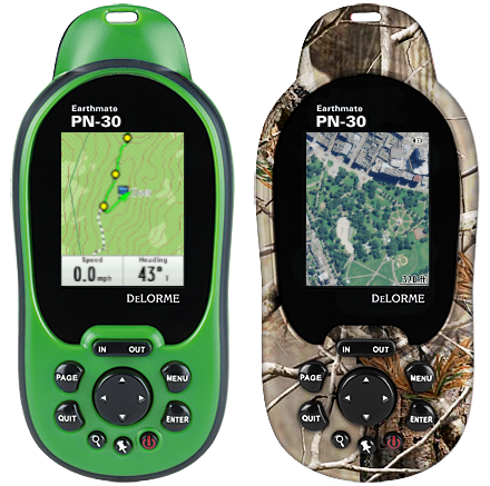
The Hunter’s Advantage |
- The Earthmate PN-30c has an authentic Realtree AP case.
Each device contains a unique pattern so no two devices are
exactly alike.
- Built especially for hunters on the same rock-solid
color-screen design platform of the PN-40, (without its
electronic compass and barometric altimeter), the PN-30 is
an incredible value.
- With a GPS compass, automatic road and trail routing,
back-on-track recalculations and turn-by turn directions the
PN-30 will get you to and around your hunting range quickly.
- The unrivaled selection of map, chart and aerial imagery
options means you will always have the most complete
navigation information available, and the most realistic
view of the terrain around you.
|
|
|
|
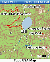
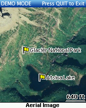
Sample Screens |
|
|
|
|
|
|
|
Specifications |
|
|
|
Part Number |
AE-8091-201 (Green), AE-8093-201 (Camo) |
|
Unit Dimensions |
2.43" x 5.25" x 1.50" (6.2 cm x 13.3 cm x 3.8 cm) |
|
Display Size |
1.38" x 1.75" (3.5 cm x 4.4 cm), 2.2" (5.6 cm) diagonal |
|
Display Resolution |
176 x 220 |
|
Display Type |
65K
Color Transflective TFT |
|
Weight |
5.35 oz (152 g) without batteries |
|
Battery Type |
AA x 2 or Rechargeable Li-Ion |
|
Battery Life |
20 hours (Lithium AA), 12 hours (Alkaline AA), 11 hours
(Rechargeable Li-ion) |
|
Sleep When Stationary Mode |
No |
|
Stealth Mode |
Yes |
|
Button Lock |
Yes |
|
Operating Temperature |
-4° F to 167° F (-20° C to 75° C) |
|
Storage Temperature |
-49° F to 212° F (-45° C to 100° C) |
|
Impact Resistance |
MIL STD 810F |
|
Waterproof |
IPX7 |
|
Floats |
No |
|
Interface |
Proprietary 8-pin USB cable |
|
Dual-Core Processor |
Yes |
|
GPS Receiver |
STM Cartesio (32 Channel) with ContantLock satellite retention
and predictive GPS |
|
GPS Antenna |
Patch |
|
GPS Constellations |
GPS +
WAAS |
|
GPS Kalman Filter |
Yes |
|
GPS Position
Accuracy (95%) |
< 15 meters (GPS), < 3 meters (WAAS) |
|
GPS Velocity Accuracy |
0.05 meter / second steady state |
|
GPS Hot Start |
5 - 6 seconds |
|
GPS Warm Start |
< 45 seconds |
|
GPS Cold Start |
< 60 seconds |
|
GPS Update Rate |
1 / second, continuous |
|
Pairs With SPOT / inReach |
No |
|
Altimeter |
GPS |
|
Barometer |
No |
|
Compass |
GPS |
|
Accelerometer |
No |
|
Routes |
50 |
|
Tracks |
10 (10,000 points per track) |
|
Waypoints /
Geocaches |
Unlimited (1,000 per GPX) |
|
Almanac Information |
Yes (Tides, Sun and Moon, Hunt and Fish) |
|
Point-to-Point Navigation |
Yes |
|
On Road Navigation |
Yes |
|
Trip Info |
Yes |
|
Track Log |
Yes |
|
Internal Memory |
503 MB |
|
Expandable Memory |
SD card (max 32 GB) |
|
Pre Loaded Base Map |
Yes (detailed highway-level worldwide basemap) |
|
Can
Add Maps |
Yes |
|
|
|
|
|
Documents |
|
|
|
Earthmate PN-40/30 User Manual |
|
Earthmate PN-Series Quick Start Guide |
|
Earthmate PN-Series User Manual (update 2.6) |
|
Earthmate PN-Series
Features |
|
Compare Earthmate PN-20 vs PN-30 vs PN-40 |
|
|
|
|
|
Media |
|
|
|
24JUN09 - DeLorme Earthmate GPS PN-30 Introduction |
|
24JUN09 - DeLorme Announces Topo USA 8.0 |
|
24JUN09 - Earthmate PN-Series Now Support Navionics Lake
and Marine Charts |
|
24JUN09 -
Streamlined Geocaching for
Earthmate PN-Series GPS with Cache Register Widget |
|
23JUN10 -
DigitalGlobe to Provide High-Resolution Earth Imagery for
Handheld GPS Devices |
|
|
|
|
|
Update History |
|
|
|
Check Firmware Version |
|
|
|
2.9 (15JUN12) (PN-30
/ PN-40) |
- Updates the PN-Series GPS with the ability to connect to Mac
OS X 10.7 (Lion).
|
|
|
|
2.8 (29SEP10) (PN-30
/ PN-40) |
- New file management (waypoints / geocaches / tracks can
be saved and loaded from GPX files stored on the SD card).
- Project a waypoint / geocache "Look ahead" feature for
sighting downrange.
- Stealth mode added - Enforces sound and light discipline.
- Button locking prevents accidental unit activation or
data input (enabled using the Power button).
- Screen flipping.
- Ability to use track to compute acreage.
- Can now view Atlas and Gazetteer symbols (with
descriptions).
- Changes to power button functions (including taking
screenshots).
- New Topo North America 9.0 base data.
|
|
|
|
2.7 (24NOV09) (PN-30
/ PN-40) |
|
Note:
This firmware is intended to update the PN-Series GPS to use
XMap Forms, it is not intended as a general consumer release
for non XMap users.
|
- Added support for forms created with XMap Forms in XMap
7. See XMap Forms for more information about forms.
- Added support for editing form data and re-classifying
data. Forms must be created with edit permissions to
edit/classify on the device.
- Added ability to work with GPX files on an SD card.
Point layers can be sent to the PN-40, with or without an
associated form, using XMap 7’s “Send to PN-Series Device”
option. This places the layer, saved to a GPX file, on the
SD card. When a GPX file is opened, its contents are
transferred to the PN-40’s internal memory. Data can be
edited and new points can be created. These changes can then
be saved back to the SD card for merging into the
originating layer in XMap 7.
- Added ability to copy a saved track to an SD card as a
GPX file.
- GIS layers saved to the PN-40 from the Handheld Export
tab now display as unique layers within Map Setup > Data
Layering. This allows each GIS layer to be individually
enabled or disabled.
- Added a Layer Details menu option to Data Layering. This
allows you to determine the database and server from which
each GIS layer originated.
|
|
|
|
2.6 (06JUL09) (PN-30
/ PN-40) |
- Navionics Electronic Charts support:
- Added support for viewing Navionics HotMaps Premium Lake
Maps 2008 and 2009 and GOLD+ Marine Charts.
- Added pick info on Navionics Charts.
- Added support for viewing Port services on GOLD+ Marine
Charts.
- Added support for Navionics Tide stations.
- Geocaching support:
- Enhanced Geocaching details page.
- Device UI:
- Improved Average Speed calculation.
- Improved Tide Station accuracy.
- Electrical:
- Reduced chance of reset when device is hot swapped on
the USB port.
- Note: Navionics HotMaps Platinum, Marine Platinum and
Platinum + are not supported.
|
|
|
|
|


