|
|
|
|
|
|
|
|
|
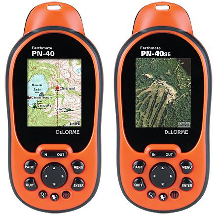
Overview |
|
|
|
Serious Performance |
- NEW! Blazing-fast, high-sensitivity 32-channel
STMicroelectronics Cartesio chipset
- NEW! Dual-core processor for instantaneous map and
satellite imagery redraws, even with large aerial imagery
files and multiple maps layers
- 360° raster rotation sets the PN-40 apart from other
common GPS handhelds. With 360° rotation road, building, and
other images really are on your left or right as you look at
the map and walk, bike or drive
- NEW! 3-axis electronic compass with included
accelorometer performs when held in any position—while in
motion or standing still
- NEW! Sensitive barometric altimeter for reliably
accurate altitude readings
- WAAS-enabled for accuracy within 3 meters
- NEW! Now supports SDHC high-capacity SD cards (up to 32
GB) for fast and direct map transfer from the included maps
discs
|
|
|
|
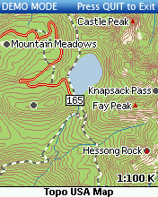
Serious Maps |
- Included. Comes with three discs containing detailed
hybrid 1:100k topographic and street maps of the entire USA.
You do not need anything else to hike, geocache, or navigate
the backcountry. It's all in the box.
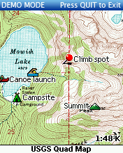
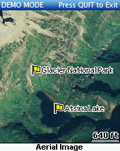
- Also Included: Sample Certificate. A $40 certificate is
included for downloading sample supplementary datasets. Take
a "test drive" with any of the supplementary datasets
DeLorme offers: high-resolution aerial imagery, USGS
7.5-Minute Quad Map, NOAA Nautical Charts, and more...
- And for Only $29.95! Then, once you're convinced,
subscribe to the NEW DeLorme Map Library for only $29.95 per
year. Get all the USGS Quads, NOAA nautical charts and
high-resolution color aerial imagery to layer WITH your topo
and street maps for only $29.95! No hidden charges.
|
|
|
|
Serious Tough |
- The PN-40 is waterproof to the IEC 529 IPX7 standard
- Designed to function in high-humidity environments,
including consistent humidity levels over 90%, and in the
rain
- The PN-40 has been rigorously tested to function in
high-vibration conditions such as off-road driving
- Operating temperature range for the PN-40 is -20 degrees
C to +75 degrees C. The PN-40 should function in extreme
cold as well as rapidly-changing temperature environments
|
|
|
|
Serious Value |
- No one else offers COMPLETE U.S. hybrid, routable
Topographic and Street maps WITH your initial purchase
- In addition, for the extremely low price of $29.95
annually, subscribe to the DeLorme Map Library of downloads
for all the USGS 7.5-minute Quads, NOAA nautical charts, and
Hi-Resolution Aerial Imagery you want. All downloads are
accessed through the convenient NetLink tab of your DeLorme
software
|
|
|
|
Serious Quality, Service & Support |
- And as if the PN-40, Included Topo and Detailed Street
Map and the huge values of the MapLibrary Subscription were
not enough, you get serious DeLorme quality:
- Renowned DeLorme-Quality Maps
- Quality Geospatial Engineering
- Quality Hardware Engineering
- Quality U.S.-Based Customer Service
- Quality U.S.-Based Technical Support and Open Online GPS
User Forums
|
|
|
|
High-Performance Technology |
- Features STMicroelectronics Cartesio chipset and updated
DeLorme firmware for amazing signal acquisition and
retention, map scrolling and redraw – even with multiple
layers of imagery, topo and street maps.
|
|
|
|
Multiple Views of the Same GPS Location |
- On-device data layering lets you select which map or
imagery type to see of your GPS location. Switch among data
types to gain a comprehensive view of where you are – it's
revolutionary and provides a whole new level of geographic
detail.
|
|
|
|
Bright Color Screen |
- Works in bright sunlight to total darkness. Sharp brand
screen featuring the latest transflective screen
technologies to maximize visibility under a variety of
lighting conditions.
|
|
|
|
Rugged and Waterproof |
- Conforms to IPX-7 waterproof standard with
impact-resistant rubberized housing for a solid grip.
Concealed battery compartment with SD card slot. Includes
two AA batteries.
|
|
|
|
Easy Exchange of Maps, Tracks, and Waypoints |
- Exchange routes, tracks and waypoints between the GPS
and Topo USA (two-way transfers).
|
|
|
|
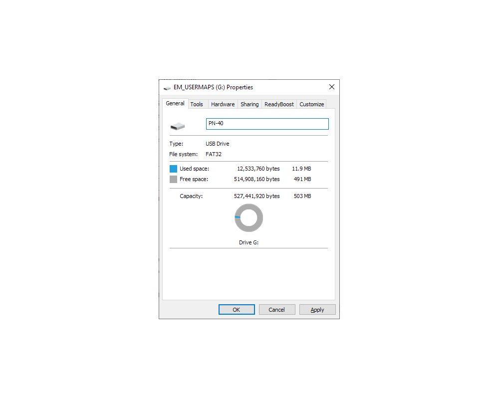
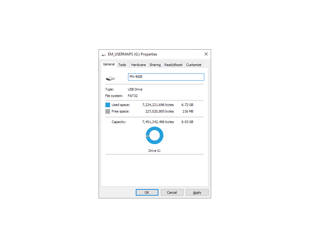
Extensive On-Device Memory |
- 500 MB (PN-40) or 8 GB (PN-40SE) of available internal flash memory in addition to
the pre-loaded world base map. Holds up to ten tracks
(10,000 points per track); 1,000 user-defined waypoints; and
50 routes. SD slot also available.
|
|
|
|
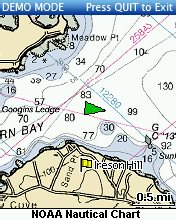
Sample Screens |
|
|
|
|
|
|
|
Specifications |
|
|
|
Part Number |
AE-7985-201 (PN-40), AE-8109-101 (PN-40SE) |
|
Unit Dimensions |
2.43" x 5.25" x 1.50" (6.2 cm x 13.3 cm x 3.8 cm) |
|
Display Size |
1.38" x 1.75" (3.5 cm x 4.4 cm), 2.2" (5.6 cm) diagonal |
|
Display Resolution |
176 x 220 |
|
Display Type |
65K
Color Transflective TFT |
|
Weight |
5.35 oz (152 g) without batteries |
|
Battery Type |
AA x 2 or Rechargeable Li-Ion |
|
Battery Life |
18 hours (Lithium AA), 9 hours (Alkaline AA), 10 hours
(Rechargeable Li-ion) |
|
Sleep When Stationary Mode |
No |
|
Stealth Mode |
Yes |
|
Button Lock |
Yes |
|
Operating Temperature |
-4° F to 167° F (-20° C to 75° C) |
|
Storage Temperature |
-49° F to 212° F (-45° C to 100° C) |
|
Impact Resistance |
MIL STD 810F |
|
Waterproof |
IPX7 |
|
Floats |
No |
|
Interface |
Proprietary 8-pin USB cable |
|
Dual-Core Processor |
Yes |
|
GPS Receiver |
STM Cartesio (32 Channel) with ContantLock satellite retention
and predictive GPS |
|
GPS Antenna |
Patch |
|
GPS Constellations |
GPS +
WAAS |
|
GPS Kalman Filter |
Yes |
|
GPS Position
Accuracy (95%) |
< 15 meters (GPS), < 3 meters (WAAS) |
|
GPS Velocity Accuracy |
0.05 meter / second steady state |
|
GPS Hot Start |
5 - 6 seconds |
|
GPS Warm Start |
< 45 seconds |
|
GPS Cold Start |
< 60 seconds |
|
GPS Update Rate |
1 / second, continuous |
|
Pairs With SPOT / inReach |
No |
|
Altimeter |
Yes |
|
Barometer |
Yes |
|
Compass |
3D |
|
Accelerometer |
Yes |
|
Routes |
50 |
|
Tracks |
10 (10,000 points per track) |
|
Waypoints /
Geocaches |
Unlimited (1,000 per GPX) |
|
Almanac Information |
Yes (Tides, Sun and Moon, Hunt and Fish) |
|
Point-to-Point Navigation |
Yes |
|
On Road Navigation |
Yes |
|
Trip Info |
Yes |
|
Track Log |
Yes |
|
Internal Memory |
503 MB (PN-40),
6.93 GB (PN-40SE) |
|
Expandable Memory |
SD card (max 32 GB) |
|
Pre Loaded Base Map |
Yes (detailed highway-level worldwide basemap) |
|
Can
Add Maps |
Yes |
|
|
|
|
|
Documents |
|
|
|
Earthmate PN-40 Quick Start Guide |
|
Earthmate PN-40 User Manual |
|
Earthmate PN-40/30 User Manual |
|
Earthmate PN-40 Brochure |
|
Earthmate PN-Series Quick Start Guide |
|
Earthmate PN-Series User Manual (update 2.6) |
|
Earthmate PN-Series
Features |
|
Compare Earthmate PN-20 vs PN-30 vs PN-40 |
|
Compare Earthmate PN-40 vs PN-60 vs PN-60w |
|
|
|
|
|
Media |
|
|
|
06AUG08 - DeLorme Earthmate GPS PN-40 Introduction |
|
07JAN09 - DeLorme Earthmate GPS PN-40 Update |
|
06MAY09 - DeLorme Earthmate GPS PN-40 Expanded
Capabilities |
|
24JUN09 - DeLorme Announces Topo USA 8.0 |
|
24JUN09 - Earthmate PN-Series Now Support Navionics Lake
and Marine Charts |
|
24JUN09 -
Streamlined Geocaching for
Earthmate PN-Series GPS with Cache Register Widget |
|
23JUN10 -
DigitalGlobe to Provide High-Resolution Earth Imagery for
Handheld GPS Devices |
|
|
|
|
|
Update History |
|
|
|
Check Firmware Version |
|
|
|
2.9 (15JUN12) (PN-30
/ PN-40) |
- Updates the PN-Series GPS with the ability to connect to Mac
OS X 10.7 (Lion).
|
|
|
|
2.8 (29SEP10) (PN-30
/ PN-40) |
- New file management (waypoints / geocaches / tracks can
be saved and loaded from GPX files stored on the SD card).
- Project a waypoint / geocache "Look ahead" feature for
sighting downrange.
- Stealth mode added - Enforces sound and light discipline.
- Button locking prevents accidental unit activation or
data input (enabled using the Power button).
- Screen flipping.
- Ability to use track to compute acreage.
- Can now view Atlas and Gazetteer symbols (with
descriptions).
- Changes to power button functions (including taking
screenshots).
- New Topo North America 9.0 base data.
|
|
|
|
2.7 (24NOV09) (PN-30
/ PN-40) |
|
Note:
This firmware is intended to update the PN-Series GPS to use
XMap Forms, it is not intended as a general consumer release
for non XMap users.
|
- Added support for forms created with XMap Forms in XMap
7. See XMap Forms for more information about forms.
- Added support for editing form data and re-classifying
data. Forms must be created with edit permissions to
edit/classify on the device.
- Added ability to work with GPX files on an SD card.
Point layers can be sent to the PN-40, with or without an
associated form, using XMap 7’s “Send to PN-Series Device”
option. This places the layer, saved to a GPX file, on the
SD card. When a GPX file is opened, its contents are
transferred to the PN-40’s internal memory. Data can be
edited and new points can be created. These changes can then
be saved back to the SD card for merging into the
originating layer in XMap 7.
- Added ability to copy a saved track to an SD card as a
GPX file.
- GIS layers saved to the PN-40 from the Handheld Export
tab now display as unique layers within Map Setup > Data
Layering. This allows each GIS layer to be individually
enabled or disabled.
- Added a Layer Details menu option to Data Layering. This
allows you to determine the database and server from which
each GIS layer originated.
|
|
|
|
2.6 (06JUL09) (PN-30
/ PN-40) |
- Navionics Electronic Charts support:
- Added support for viewing Navionics HotMaps Premium Lake
Maps 2008 and 2009 and GOLD+ Marine Charts.
- Added pick info on Navionics Charts.
- Added support for viewing Port services on GOLD+ Marine
Charts.
- Added support for Navionics Tide stations.
- Geocaching support:
- Enhanced Geocaching details page.
- Device UI:
- Improved Average Speed calculation.
- Improved Tide Station accuracy.
- Electrical:
- Reduced chance of reset when device is hot swapped on
the USB port.
- Note: Navionics HotMaps Platinum, Marine Platinum and
Platinum + are not supported.
|
|
|
|
2.5 (29APR09) (PN-40) |
- Geocaching Support:
- Added a Geocaching page, which separates Geocaches from
Waypoints. This page allows you to sort Geocaches by
Name/Distance/Logged/Not Logged.
- Geocache/Waypoint Comment character limit increased from
800 to 15,000 characters. Currently, this is only for
Geocaches sent to the PN-40 using the Send to GPS Plugin
(http://www.delorme.com/geocaching/plugin/). When Topo USA
8.0 and the Cache Register application are released, they
will also support the 15,000 character limit.
- Added graphics to the Geocache Comment page which
indicate Size, Difficulty and Terrain.
- Difficult/Terrain and Cache Size Info Fields
(non-editable) now display directly within the Geocache
Details page (as well as their standard location within the
Geocache Comment).
- Moved the Hint to the bottom of the Comment for
Geocaches sent from the Send to GPS Plugin and Cache
Register.
- Added a View Hint menu option to the Geocache Details
page.
- Added new Geocaching Symbols to match those used by
Geocaching.com.
- Field Notes support allows you to create field notes
directly on the PN-40, which can then be uploaded through
your account at www.geocaching.com.
- Added a View Field Notes menu option to the Geocache
page. Note that this is View only. You cannot edit existing
Field Notes on the device.
- Geocaching wizard steps you through the process of
Routing to a Geocache, Logging your Geocache find, Entering
a Field Note then moving on to the next Geocache you want to
find (closest, or selected from the list).
- Waypoints/Geocaches:
- Geocaches and Waypoints pages now display the number of
each on the page's Title.
- General improvements to Waypoints and Geocaches to
improve stability, reduce corruption and prevent duplicates.
If you have been part of the Beta process (private or
public), you may need to use Memory Management to delete
BOTH Waypoints and Geocaches (check both boxes at the same
time) in order to get back into a good state. People
updating directly from 2.4 to 2.5 shouldn't have to do this.
- Memory Management:
- Added a Memory Use page which allows you to view the
number of Waypoints/Geocaches/Tracks/Routes on your device,
as well as how much free space you have on both the SD card
and Internal Memory.
- Added a Memory Management page which allows you to
easily delete all Waypoints/Geocaches/Tracks/Routes.
- Routing:
- Added an option to allow the user to specify the speed
for Direct Routes.
- Road and Direct have been replaced with Drive and Hike
in all routing scenarios.
- Routing method drop-down menu on the Create Route page
has been replaced by a pop-up asking if you want to Drive or
Hike after hitting the Navigate button.
- Prepared routing engine for release of Topo USA 8.0.
- Resolved a routing problem that was reported in Public
Beta 2.
- Device UI:
- Adjustments to font sizes to make data within info
fields easier to read.
- Added a setting which allows the PN-40 to automatically
switch to Midnight colors at Sunset, and back to normal at
Sunrise.
- Remapped device buttons while virtual keyboard is
displayed. In Button: Deletes last character. Out Button:
Space. Find Button: Shift. Mark Button: Jumps highlight to
OK.
- Text Display change so that seconds display in larger
font until hours are available, then they return to small
font.
- Added single press of arrow key on Map Page to enable
the backlight w/o entering Pan mode.
- Current field is now highlighted in list when Changing
Info Field.
- Added a Map Point Management button to the Map Setup
menu. This brings up a page where you can control how POIs'
/ Waypoints / Geocaches display on the map. You can set them
to display with Large or Small symbols, and control what
Zoom levels they display at. There is also a new option here
to Hide Logged Caches on the map (even though it can be fun
to see all those Smilies, it can be useful to have a view
that only shows Not Logged only).
- GPS:
- Added support for Predictive Ephemeris. This allows the
PN-40 to predict satellite positions up to 5 days out, and
within a 100 mile radius, resulting in faster acquisition
times at startup. A Predicted Ephemeris fix is indicated by
Yellow satellite bars and a yellow GPS position indicator on
the map.
- Improvements to WAAS which allow the PN-40 to lock onto
a WAAS satellite at lower signal strengths.
- Improvements to GPS reacquisition after a loss of
signal.
|
|
|
|
2.4 (17DEC08) (PN-40) |
- The Connect to Computer dialog on the PN-40 should now
be more reliable. This should resolve cases where the dialog
did not appear on the PN-40, and your PC did not make the
"USB Device Connected" sound.
- The PN-40 should no longer reset or lock up when
connecting/disconnecting the USB cable on the device side.
If it does lock up while performing this action, the wait
for a reset is now less. Remember, as with most USB devices,
best practice is to connect the USB cable to the device
before powering it on.
- Battery type (1-Cell Li-Ion vs 2-Cell Alkalines)
detection has been improved. This should prevent the device
from shutting down too soon when swapping from Li-Ion
batteries to NiMh. Please note that battery type detection
only changes the Type between Li-Ion and Alkaline. If you
boot with NiMh batteries, you will still need to change the
setting from Alkaline to NiMh in order to have the correct
battery profile.
- Fixed a case where the PN-40 could display as an Invalid
Removable Drive when set to either SD Transfer Mode or
Internal Transfer Mode.
- Resolved an issue where the PN-40 USB connection might
not respond properly when receiving commands from unknown
desktop drivers/applications.
- Resolved an issue where it might take longer to change
from Data Exchange mode to Map Transfer mode when connected
to certain desktop systems.
- Resolved an issue where disabling WAAS, then
disabling/enabling GPS would improperly enable WAAS again.
The WAAS preference setting should be independent of the GPS
setting.
|
|
|
|
2.3 (05DEC08) (PN-40) |
- The Connect to Computer dialog on the PN-40 should now
be more reliable. This should resolve cases where the dialog
did not appear on the PN-40, and your PC did not make the
"USB Device Connected" sound.
- The PN-40 should no longer reset or lock up when
connecting/disconnecting the USB cable on the device side.
If it does lock up while performing this action, the wait
for a reset is now less. Remember, as with most USB devices,
best practice is to connect the USB cable to the device
before powering it on.
- Battery type (1-Cell Li-Ion vs 2-Cell Alkalines)
detection has been improved. This should prevent the device
from shutting down too soon when swapping from Li-Ion
batteries to NiMh. Please note that battery type detection
only changes the Type between Li-Ion and Alkaline. If you
boot with NiMh batteries, you will still need to change the
setting from Alkaline to NiMh in order to have the correct
battery profile.
- Fixed a case where the PN-40 could display as an Invalid
Removable Drive when set to either SD Transfer Mode or
Internal Transfer Mode.
|
|
|
|
|


